Tahawus in Essex County, New York — The American Northeast (Mid-Atlantic)
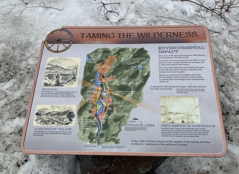
Taming the Wilderness
Environmental Impact
Men set to work upon first arrival in 1826 altering the landscape to suit their needs.
The forest was cut to expose the ore beds, to clear land for crops, to make lumber for housing, and to make charcoal for the furnace.
The rivers were dammed and streams diverted to provide the power needed to produce and transport iron and supplies.
Resources seemed to be limitless and there for the taking with no need for conservation; a concept that was foreign to the businessmen of the era.
Gradually the clearings became larger, with acres of burnt. and half-rotted stumps."
Writer Richard H. Dana upon emerging from Indian Pass in 1849, still 4½ miles from the village.
Field Sketch Of Adirondack
Landscape artist Thomas Cole sketched this view, looking northwest into the village as it appeared in 1846. An early blast furnace (built in 1844) is shown in action in the center and the charcoal kilns and sheds are shown to the left of the furnace. Note the cleared foreground and mountain sides.
Iron Dam
This 1866 Benson J. Lossing engraving shows the iron dam, a natural outcropping of iron-bearing rock extending across the river. A timber crib dam was built on top of the iron dam to create a greater drop.
Adirondack Village
This 1859 Benson J. Lossing engraving shows a view of the thriving village at its peak from a high spot to the southwest.
Today, little evidence remains of the impacts of the mining activities on this site - testimony to the resilience of nature.
Adirondack c.1854
Place names and spelling taken from Emmons' 1854 map of beds and veins of magnetic irom oxide at Adirondack (the village of Adirondac was spelled with or without the "k” depending on the source).
Map Details (north to south)
- The Adirondack Iron and Steel Company owned 105,000 acres of land, centered on the upper Hudson River valley.
- High elevation lakes were dammed and water was diverted into Calamity Brook to enhance water flow upstream of the village water wheels.
- The virgin forest was cut for miles around to make charcoal to feed the furnaces.
- Clay was mined to make bricks.
- The Adirondack (Hudson) River was dammed in at least 4 places to provide head for waterwheels and to expand navigability.
- Land was cleared and tilled near the village to grow crops and graze livestock.
- Ore beds in the valley were located and mined.
- Pine logs were sold from more remote areas of the holdings and cut for sawtimber to help finance the operation.
- The river was dammed and navigable for another two miles to Lower Works.
Erected by Open Space Institute.
Topics. This historical marker is listed in these topic lists: Environment • Industry & Commerce • Settlements & Settlers. A significant historical year for this entry is 1826.
Location. 44° 5.249′ N, 74° 3.363′ W. Marker is in Tahawus, New York, in Essex County. Marker is on Upper Works Road (County Route 25) 9.7 miles north of Blue Ridge Road, on the left when traveling north. Touch for map. Marker is in this post office area: Newcomb NY 12879, United States of America. Touch for directions.
Other nearby markers. At least 8 other markers are within walking distance of this marker. Lazy Lodge (a few steps from this marker); Three Communities (a few steps from this marker); W.R.K. Taylor Jr. (within shouting distance of this marker); Abbott/Lockwood (within shouting distance of this marker); An Abundance of Ore (within shouting distance of this marker); Jennings Cottage (within shouting distance of this marker); Transportation (within shouting distance of this marker); The Club Era (within shouting distance of this marker). Touch for a list and map of all markers in Tahawus.
Also see . . . Open Space Institute. (Submitted on April 11, 2020, by Michael Herrick of Southbury, Connecticut.)
Credits. This page was last revised on June 11, 2020. It was originally submitted on April 9, 2020, by Steve Stoessel of Niskayuna, New York. This page has been viewed 85 times since then and 6 times this year. Photo 1. submitted on April 9, 2020, by Steve Stoessel of Niskayuna, New York. • Michael Herrick was the editor who published this page.
Editor’s want-list for this marker. A wide angle photo of the marker and its surroundings. • Can you help?
