Cumberland Township near Round Top in Adams County, Pennsylvania — The American Northeast (Mid-Atlantic)
The Valley of Death
July 2, 1863 - Second Day
1st Lt. Benjamin F. Rittenhouse, U.S.A.
5th U.S. Artillery, Battery D
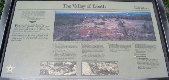
You are standing on Little Round Top looking west over Plum Run and the Valley of Death. Devil's Den and the Slaughter Pen, each a maze of rock outcrops and boulders, may be seen down the valley to your left.
On the afternoon of the second day of the battle, Union forces seized this strategic high ground which they held for the remainder of the battle. Many officers and men from both sides died in the struggle.
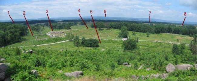
(Numbered list of items noted in the panoramic photo on marker):
(1) Warfield Ridge
This wooded ridge, an extension of Seminary Ridge, helped screen General Longstreet's attacking Confederates from the view of Union lookouts here.
(2) The Slaughter Pen
Men of the 44th and 48th Alabama Infantry fell in great numbers in this rock-strewn area. The photo below was taken by Alexander Gardner on July 6, 1863. The bloated and rain-drenched bodies had not yet been removed by Union burial details.
(3) Devil's Den
Maj. Gen. Daniel E. Sickles positioned the left flank of his Third Corps at this unusual geologic formation, thinking its rugged nature would hinder Confederate troop movements. However, Confederates captured Devil's Den on the afternoon of July 2.
From concealed places among the rocks, Southern snipers and sharpshooters kept the Union soldiers on Little Round Top under fire. The photo below was taken at a Confederate position in Devil's Den three days after the battle.
(4)Houck's Ridge
This low ridge served as a line of defense for General Sickles advanced Union line. It was the scene of desperate fighting on July 2, and finally fell to Confederates of McLaws' and Hood's Divisions late in the afternoon.
(5) The Valley of Death
Many soldiers fell here during the struggle for Little Round Top. Correspondent Whitelaw Reid of the Cincinnati Gazette reported from Gettysburg: "Who shall say that they did not go down into the very Valley of the Shadow of Death that terrible afternoon."
(6) South Mountain
(7) Seminary Ridge
(8) The Peach Orchard
An advanced Union line commanded by Maj. Gen. Daniel E. Sickles formed a salient or projecting angle, here at John Sherfy's peach orchard on July 2. His left extended southeast to Devil's Den, while his right ran north along the Emmitsburg Road. A series of Confederate attacks drove Sickles' men back.
Erected by Gettysburg National Military Park.
Topics. This historical marker is listed in this
topic list: War, US Civil. A significant historical date for this entry is July 2, 1863.
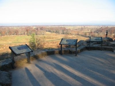
Location. 39° 47.53′ N, 77° 14.202′ W. Marker is near Round Top, Pennsylvania, in Adams County. It is in Cumberland Township. Marker can be reached from Sykes Avenue, on the left when traveling north. Located at stop 8, Little Round Top, on the driving tour of Gettysburg National Military Park. Touch for map. Marker is in this post office area: Gettysburg PA 17325, United States of America. Touch for directions.
Other nearby markers. At least 8 other markers are within walking distance of this marker. The Union Fishhook (here, next to this marker); 91st Pennsylvania Infantry (here, next to this marker); The Eye of General Warren (a few steps from this marker); The Deadly Sharpshooters (a few steps from this marker); 91st Pennsylvania Volunteer Regiment (a few steps from this marker); Battery D Fifth U.S. Artillery (a few steps from this marker); Warren (within shouting distance of this marker); Signal Corps U.S.A. (within shouting distance of this marker). Touch for a list and map of all markers in Round Top.
More about this marker. The marker features a panoramic view of the Plum Run valley captioned You are standing on Little Round Top looking west over the Valley of Death. At the bottom of the marker are two wartime photos showing the dead around the Devil's Den.
Also see . . . Little Round Top.

Photographed By Craig Swain
3. The Valley of Death Panoramic View
Red numbers correspond to the references in the text. Significant clearing of wooded areas around the Devil's Den now offers a better view of that part of the battlefield than was able when the marker's photo was taken. The clearing is part of an ongoing park project to restore the historical wood lines.
Credits. This page was last revised on February 7, 2023. It was originally submitted on January 1, 2009, by Craig Swain of Leesburg, Virginia. This page has been viewed 2,295 times since then and 120 times this year. Photos: 1, 2, 3. submitted on January 1, 2009, by Craig Swain of Leesburg, Virginia.

