Landover in Prince George's County, Maryland — The American Northeast (Mid-Atlantic)
Development at the Wilson Farm Site

Photographed By Devry Becker Jones (CC0), June 6, 2020
1. Development at the Wilson Farm Site Marker
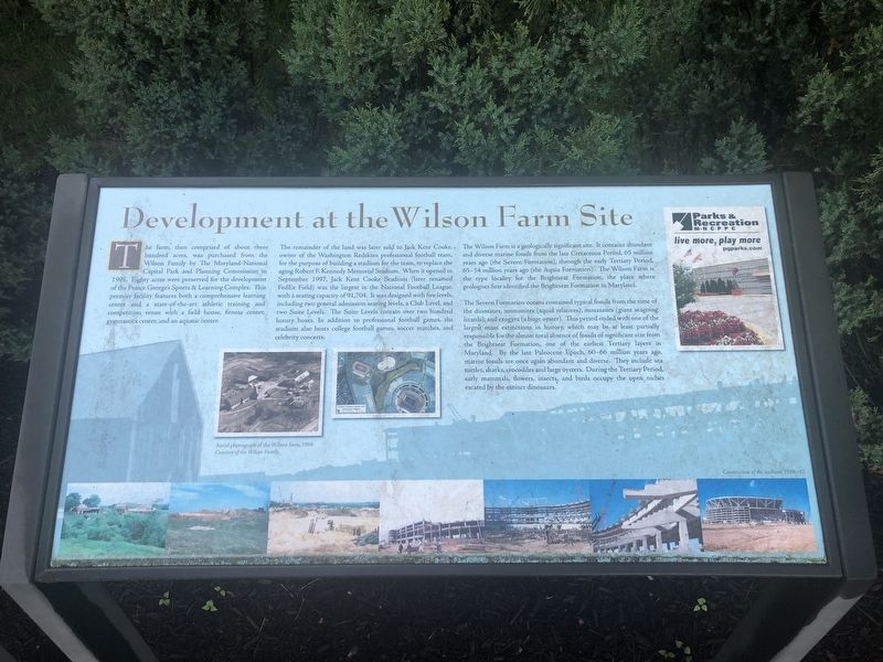
The farm, then comprised of about three hundred acres, was purchased from the Wilson Family by The Maryland-National Capital Park and Planning Commission in 1995. Eighty acres were preserved for the development of the Prince George's Sports & Learning Complex. This premier facility features both a comprehensive learning center and a state-of-the-art athletic training and competition venue with a field house, fitness center, gymnastics center, and an aquatic center.
The remainder of the land was later sold to Jack Kent Cooke, owner of the Washington Redskins professional football team for the purpose of building a stadium for the team, to replace the aging Robert F. Kennedy Memorial Stadium. When it opened in September 1997, Jack Kent Cooke Stadium (later renamed FedEx Field) was the largest in the National Football League, with a seating capacity of 91,704. It was designed with five levels, including two general admission seating levels, a Club Level, and two Suite Levels. The Suite Levels contain over two hundred luxury boxes. In addition to professional football games, the stadium also hosts college football games, soccer matches, and celebrity concerts.
The Wilson Farm is a geologically significant site. It contains abundant and diverse marine fossils from the late Cretaceous Period, 65 million years ago (the Severn Formation), through the early Tertiary Period, 65-54 million years ago (the Aquia Formation). The Wilson Farm is the type locality for the Brightseat Formation, the place where geologists first identified the Brightseat Formation in Maryland.
The Severn Formation oceans contained typical fossils from the time of the dinosaurs, ammonites (squid relatives), mososaurs (giant seagoing lizards), and exogyra (a huge oyster). This period ended with one of the largest mass extinctions in history, which may be at least partially responsible for the almost total absence of fossils of significant size from the Brightseat Formation, one of the earliest Tertiary layers in Maryland. By the late Paleocene Epoch, 60-66 million years ago, marine fossils are once again abundant and diverse. They include sea turtles, sharks, crocodiles and large oysters. During the Tertiary Period, early mammals, flowers, insects, and birds occupy the open niches vacated by the extinct dinosaurs.
Erected by Maryland-National Capital Parks and Planning Commission.
Topics. This historical marker is listed in these topic lists: Animals • Parks & Recreational Areas • Sports. A significant historical month for this entry is September 1997.
Location. 38° 54.731′ N, 76° 51.982′ W. Marker is in Landover, Maryland

Photographed By Devry Becker Jones (CC0), June 6, 2020
2. Development at the Wilson Farm Site Marker
Other nearby markers. At least 8 other markers are within walking distance of this marker. History of the Wilson Farm (here, next to this marker); Marvin F. Wilson Stadium (approx. 0.2 miles away); Osborne Perry Anderson (approx. ¾ mile away); Christian A Fleetwood (approx. ¾ mile away); Thomas R Hawkins (approx. ¾ mile away); Elizabeth Keckly (approx. ¾ mile away); Veterans Memorial (approx. 0.8 miles away); This Memorial Honors Philip Reed (approx. 0.8 miles away). Touch for a list and map of all markers in Landover.
Credits. This page was last revised on June 6, 2020. It was originally submitted on June 6, 2020, by Devry Becker Jones of Washington, District of Columbia. This page has been viewed 773 times since then and 50 times this year. Photos: 1, 2. submitted on June 6, 2020, by Devry Becker Jones of Washington, District of Columbia.