College Hill in Providence in Providence County, Rhode Island — The American Northeast (New England)
Providence Preservation Organizations
Photographed by Devry Becker Jones (CC0), June 19, 2020
1. Providence Preservation Organizations Marker
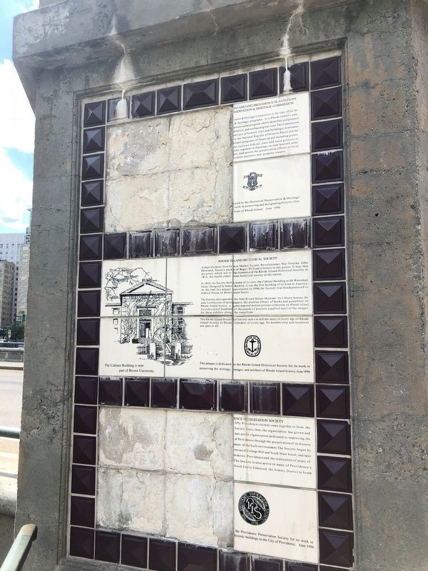
In 1844, the Society built a home of its own, the Cabinet Building at 68 Waterman Street. Designed by James Bucklin, it was the first building of its kind in America. At the time this plaque was erected in 1996, the Society was headquartered in Aldrich House on Benevolent Street.
The Society also operates the John Brown House Museum. Its Library houses the state's collection of newspapers, the premier library of books and pamphlets on Rhode Island history, a great map and motion picture collection of Rode Island. Its collection of hundreds of thousands of pictures supplied most of the images for these exhibits along the
this page online
The Rhode Island Historical Society seeks to tell the story of every age of Rhode Island's history from Rhode Islanders of every age. Its membership and resources are open to all.
The Cabinet Building is now part of Brown University.
This plaque is dedicated to the Rhode Island Historical Society for its work in preserving the writings, images, and artifacts of Rhode Island history. June 1996
Erected 1996.
Topics. This historical marker is listed in these topic lists: Education • Notable Buildings. A significant historical month for this entry is June 1996.
Location. 41° 49.594′ N, 71° 24.574′ W. Marker has been reported damaged. Marker is in Providence, Rhode Island, in Providence County. It is in College Hill. It can be reached from the intersection of Washington Place and Canal Walk, on the right when traveling east. Touch for map. Marker is at or near this postal address: 55 Canal Walk, Providence RI 02903, United States of America. Touch for directions.

Regionally, this marker is on Rhode Island’s Narragansett Bay. It is also in the American Northeast, in New England, and on the Eastern Seaboard. Globally, it is in the North Atlantic Region, North America, the Western Hemisphere, the Western World, and the Anglosphere. Historically, it finds itself in what was once one of the original Thirteen Colonies.
Other nearby markers. At least 8 other markers are within walking distance of this location: The First Baptist Meetinghouse (here, next to this marker); World War I Monument (a few steps from this marker); Washington Street (within shouting distance of this marker); Steeple Street (within shouting distance of this marker); The Woonasquatucket River (within shouting distance of this marker); The Moshassuck River (within shouting distance of this marker); Steeple Street Complex (about 300 feet away, measured in a direct line); a different marker also named Steeple Street (about 300 feet away). Touch for a list and map of all markers in Providence.
Credits. This page was last revised on February 8, 2023. It was originally submitted on June 22, 2020, by Devry Becker Jones of Washington, District of Columbia. This page has been viewed 203 times since then and 11 times this year. Photo 1. submitted on June 22, 2020, by Devry Becker Jones of Washington, District of Columbia.
