Downtown in Hartford in Hartford County, Connecticut — The American Northeast (New England)
Hartford's Isle of Safety
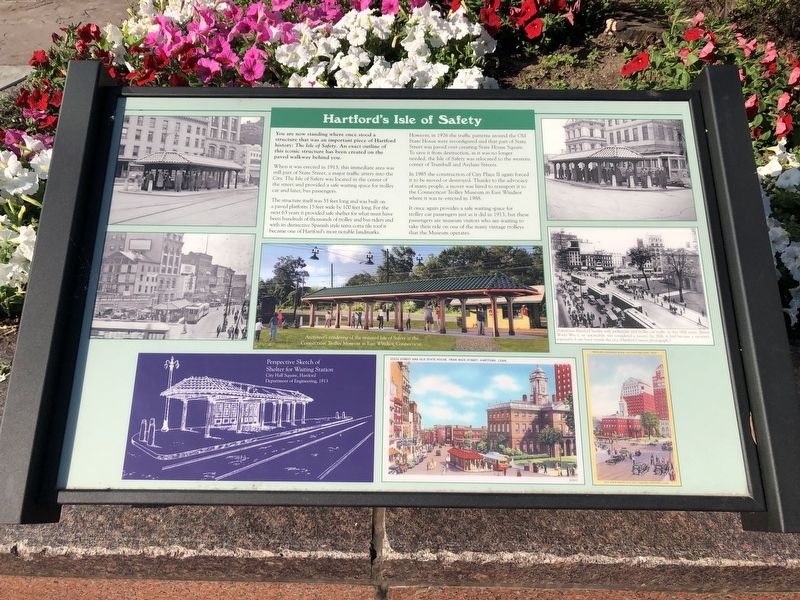
You are now standing where once stood a structure that was an important piece of Hartford history: The Isle of Safety. An exact outline of this iconic structure has been created on the paved walkway behind you.
When it was erected in 1913, this immediate area was still part of State Street, a major traffic artery into the City. The Isle of Safety was located in the center of the street and provided a safe waiting space for trolley car and later, bus passengers.
The structure itself was 55 feet long and was built on a paved platform 15 feet wide by 100 feet long. For the next 63 years it provided safe shelter for what must have been hundreds of thousands of trolley and bus riders and with its distinctive Spanish style terra cotta tile roof it became one of Hartford's most notable landmarks.
However, in 1976 the traffic patterns around the Old State House were reconfigured and that part of State Street was paved over creating State House Square. To save it from destruction, as it was no longer needed, the Isle of Safety was relocated to the western corner of Trumbull and Asylum Streets.
In 1985 the construction of City Place II again forced it to be moved or destroyed. Thanks to the advocacy of many people, a mover was hired to transport it to the Connecticut Trolley Museum in East Windsor where it was re-erected in 1988.
It once again provides a safe waiting space for trolley car passengers just as it did in 1913, but these passengers are museum visitors who are waiting to take their ride on one of the many vintage trolleys that the Museum operates.
Topics. This historical marker is listed in these topic lists: Notable Places • Railroads & Streetcars • Roads & Vehicles. A significant historical year for this entry is 1913.
Location. 41° 46.015′ N, 72° 40.32′ W. Marker is in Hartford, Connecticut, in Hartford County. It is in Downtown. Marker is on State House Square just east of Main Street, on the left when traveling east. Touch for map. Marker is at or near this postal address: 30 State House Square, Hartford CT 06103, United States of America. Touch for directions.
Other nearby markers. At least 8 other markers are within walking distance of this marker. James Goodwin Batterson (about 300 feet away, measured in a direct line); Alexis de Tocqueville (about 300 feet away); Adrićn Block (about 300 feet away); The Fundamental Orders of Connecticut (about 300 feet away); The Tower Clock (about 300 feet away); Captain Joseph Wadsworth (about 300 feet away); Jonathan Trumbull (about 300 feet away); Old State House (about 300 feet away). Touch for a list and map of all markers in Hartford.
Credits. This page was last revised on February 10, 2023. It was originally submitted on June 25, 2020, by Devry Becker Jones of Washington, District of Columbia. This page has been viewed 366 times since then and 36 times this year. Photos: 1, 2. submitted on June 25, 2020, by Devry Becker Jones of Washington, District of Columbia.

