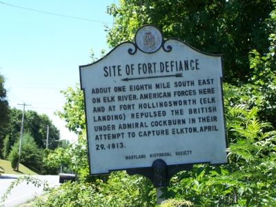
Near Elkton in Cecil County, Maryland — The American Northeast (Mid-Atlantic)
Site of Fort Defiance
Erected by Maryland Historical Society.
Topics. This historical marker is listed in these topic lists: Forts and Castles • Military • War of 1812. A significant historical date for this entry is April 29, 1836.
Location. Marker has been reported missing. It was located near 39° 35.527′ N, 75° 51.392′ W. Marker was near Elkton, Maryland, in Cecil County. Marker was on Old Field Point Road, 0.1 miles north of Jones Chapel Road, on the right when traveling south. Touch for map. Marker was in this post office area: Elkton MD 21921, United States of America. Touch for directions.
Other nearby markers. At least 8 other markers are within walking distance of this location. Spirited Rebuff (approx. ¾ mile away); Stone House (approx. 0.9 miles away); Native Americans in the 1600's (approx. 0.9 miles away); Henry Deibert and E. Deibert Bros. Barge Building (approx. 0.9 miles away); Revolutionary War (approx. 0.9 miles away); Strong Defense (approx. 0.9 miles away); Carriage Steps (approx. 0.9 miles away); Hollingsworth House (approx. 0.9 miles away). Touch for a list and map of all markers in Elkton.
More about this marker. Marker not found on June 30 and July 1, 2020.
Additional keywords. British Navy Rear Admiral Sir George Cockburn
Credits. This page was last revised on July 2, 2020. It was originally submitted on July 12, 2007, by Bill Pfingsten of Bel Air, Maryland. This page has been viewed 3,876 times since then and 32 times this year. Last updated on July 2, 2020, by Carl Gordon Moore Jr. of North East, Maryland. Photo 1. submitted on July 12, 2007, by Bill Pfingsten of Bel Air, Maryland.
