Mechanicsville in Hanover County, Virginia — The American South (Mid-Atlantic)
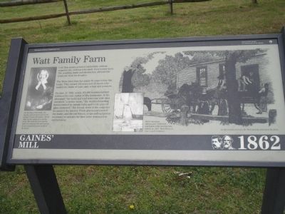
Watt Family Farm
Gaines’ Mill – 1862
— Richmond National Battlefield Park —
The Watts lived here for nearly 60 years before the battle. They owned 523 acres and 28 slaves who tended the fields of corn, oats, wheat and potatoes.
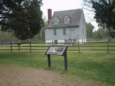
On June 27, 1862, nearly 100,000 soldiers battled within a two-mile radius of this farmhouse. In the aftermath ”the walls and roof were torn with shot and shell,” a visitor wrote, ”the weather-boarding honeycombed by Minnie balls, and every pane of glass shattered.” The bloody work of the surgeons devastated the interior. Fresh graves surrounded the house, and the rail fences, crops and equipment necessary to operate the farm were destroyed or carried away.
Erected by Richmond National Battlefield Park - National Park Service.
Topics. This historical marker is listed in this topic list: War, US Civil. A significant historical month for this entry is June 1864.
Location. This marker has been replaced by another marker nearby. It was located near 37° 34.438′ N, 77° 17.444′ W. Marker was in Mechanicsville, Virginia, in Hanover County. Marker was on Watt House Road (Virginia Route 718), on the left when traveling south. Marker is in the Gaines’ Mill Battlefield Unit of Richmond National Battlefield Park. Touch for map. Marker was in this post office area: Mechanicsville VA 23111, United States of America. Touch for directions.
Other nearby markers. At least 8 other markers are within walking distance of this location. The Watt House (here, next to this marker); Springfield Plantation (a few steps from this marker); Seven Days Battles (a few steps from this marker); Gaines' Mill (within shouting distance of this marker); The Battle of Gaines’ Mill (within shouting distance of this marker); Lee’s First Victory: At a Huge Cost (within shouting distance of this marker); Confederate Pursuit (within shouting distance of this marker); a different marker also named Battle of Gaines' Mill (about 300 feet away, measured in a direct line). Touch for a list and map of all markers in Mechanicsville.
More about this marker. The left side of the marker contains a portrait of Sarah Watt. It has a caption of “On the day of the battle, the family and servants moved the ailing 77-year-old widow, Sarah Watt, to the safety of a nearby farm. She died the next spring and it is believed she was buried in an unmarked grave south of the house. The right of the marker features a picture of the Watt family leaving their house. It has the caption “As the armies arrived, the Watt family evacuated the farm.” An inset picture of the interior
of the house contains the caption “Battle-damaged rafters were reinforced and much of the interior was rebuilt in 1957. Watt House is now a park residence.”
Related marker. Click here for another marker that is related to this marker. New Marker At This Location titled "Springfield Plantation".
Also see . . .
1. Gaines’ Mill. CWSAC Battle Summaries website. (Submitted on January 4, 2009, by Bill Coughlin of Woodland Park, New Jersey.)
2. Places To Go in Richmond National Battlefield Park. National Park Service website. (Submitted on January 4, 2009, by Bill Coughlin of Woodland Park, New Jersey.)
3. The Seven Days Battle. HistoryCentral.com website. (Submitted on January 4, 2009, by Bill Coughlin of Woodland Park, New Jersey.)
Credits. This page was last revised on November 5, 2021. It was originally submitted on January 4, 2009, by Bill Coughlin of Woodland Park, New Jersey. This page has been viewed 2,365 times since then and 201 times this year. Last updated on January 12, 2009, by Bernard Fisher of Richmond, Virginia. Photos: 1, 2, 3, 4, 5. submitted on January 4, 2009, by Bill Coughlin of Woodland Park, New Jersey. • Kevin W. was the editor who published this page.
