Mechanicsville in Hanover County, Virginia — The American South (Mid-Atlantic)
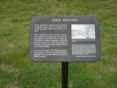
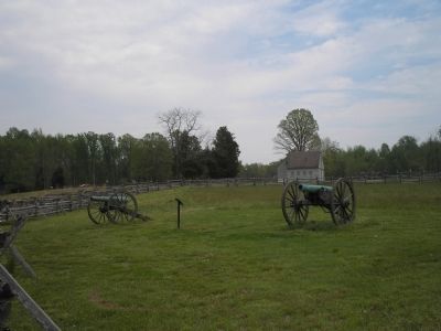
Union Artillery
“The woods were full of smoke,” wrote a Massachusetts artillerist, “and thicker and thicker buzzed the bullets.” Soon the Confederate infantry appeared. One of the Federal guns fired a double charge of canister at 35 yards range, which “mowed their ranks awfully,”
It was a last salute. Thousands of gray-clad infantry swarmed up the hill and by nightfall had captured nearly two dozen of Porter’s cannon.
“By the time we had gotten across [Boatswain’s Creek], the front line, broken by our fire, frightened by our screams which sounded like forty thousand wild cats, had … crowded to the top of the hill, thus preventing their artillery from firing into us … We ran over their artillery, killing the gunners at their guns … We paid dearly for this occasion, but they paid still more dearly, for their dead and dying lay so thick as almost to block our pursuit.”
Erected by Richmond National Battlefield Park - National Park Service.
Topics. This historical marker is listed in this topic list: War, US Civil.
Location. 37° 34.412′ N, 77° 17.527′ W. Marker is in Mechanicsville, Virginia, in Hanover County. Marker is on Watt House Road (Virginia Route 718), on the right when traveling south. Marker is in the Gaines’ Mill Battlefield Unit of Richmond National Battlefield Park. Touch for map. Marker is in this post office area: Mechanicsville VA 23111, United States of America. Touch for directions.
Other nearby markers. At least 8 other markers are within walking distance of this marker. Final Stand (a few steps from this marker); The Federal Collapse (within shouting distance of this marker); Confederate Pursuit (within shouting distance of this marker); Lee’s First Victory: At a Huge Cost (about 300 feet away, measured in a direct line); Whiting's Advance (about 400 feet away); Hood's Attack (about 400 feet away); Seven Days Battles (about 400 feet away); The Watt House (about 400 feet away). Touch for a list and map of all markers in Mechanicsville.
More about this marker. The upper right of the marker contains a drawing of the action at the Battle of Gaines’ Mill. It has the caption “The Confederates stormed out of the low ground toward the vulnerable Union cannon, depicted here in an 1862 sketch by Alfred Waud.”
Also see . . .
1. Gaines’ Mill. CWSAC Battle Summaries website. (Submitted on January 8, 2009, by Bill Coughlin of Woodland Park, New Jersey.)
2. Touring Richmond's Battlefields. Richmond National Battlefield website. (Submitted on January 8, 2009, by Bill Coughlin of Woodland Park, New Jersey.)
3. The Seven Days Battle. HistoryCentral.com website. (Submitted on January 8, 2009, by Bill Coughlin of Woodland Park, New Jersey.)
4. Gaines' Mill Battlefield Loop Trail. This marker is one along the loop trail in the Gaines' Mill Battlefield unit of the Richmond National Battlefield Park. (Submitted on February 26, 2009, by Bernard Fisher of Richmond, Virginia.)
Credits. This page was last revised on June 16, 2016. It was originally submitted on January 8, 2009, by Bill Coughlin of Woodland Park, New Jersey. This page has been viewed 1,152 times since then and 19 times this year. Last updated on January 12, 2009, by Bernard Fisher of Richmond, Virginia. Photos: 1, 2, 3, 4. submitted on January 8, 2009, by Bill Coughlin of Woodland Park, New Jersey. • Kevin W. was the editor who published this page.


