Marker Logo
THE HISTORICAL
MARKER DATABASE
“Bite-Size Bits of Local, National, and Global History”
Port Charlotte in Charlotte County, Florida — The American South (South Atlantic)
 

Murdock
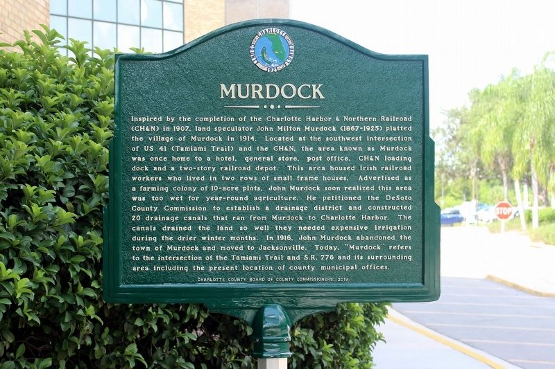
 
 
Murdock Marker image. Click for full size.
Photographed by Tim Fillmon, July 8, 2020
1. Murdock Marker
Inscription. Inspired by the completion of the Charlotte Harbor and Northern Railroad (CH&N) in 1907, land speculator John Milton Murdock (1867-1925) platted the village of Murdock in 1914. Located at the southwest intersection of US 41 (Tamiami Trail) and the CH&N, the area known as Murdock was once home to a hotel, general store, post office, CH&N loading dock, and a two-story railroad depot. This area housed Irish railroad workers who lived in two rows of small frame houses. Advertised as a farming colony of 10-acre plots, John Murdock soon realized this area was too wet for year-round agriculture. He petitioned for DeSoto County Commission to establish a drainage district and constructed drainage canals that ran from Murdock to Charlotte Harbor. The canals drained the land so well they needed expensive irrigation during the drier winter months. In 1916, John Murdock abandoned the town of Murdock and moved to Jacksonville. Today "Murdock" refers to the intersection of Tamiami Trail and SR 776 and its surrounding area, including the present location of county municipal offices.
 
Erected 2019 by Charlotte County Board of County
Paid Advertisement
Click or scan to see
this page online
Commissioners.
 
Topics. This historical marker is listed in these topic lists: Railroads & StreetcarsSettlements & Settlers. A significant historical year for this entry is 1914.
 
Location. 27° 0.53′ N, 82° 8.481′ W. Marker is in Port Charlotte, Florida, in Charlotte County. It can be reached from Murdock Circle 0.1 miles south of Tamiami Trail (U.S. 41). Marker is located in front of the Charlotte County Offices. Touch for map. Marker is at or near this postal address: 18500 Murdock Circle, Port Charlotte FL 33948, United States of America. Touch for directions.

Regionally, this marker is on Florida’s Gulf Coast. It is also in the American South and on the Gulf Coast. Globally, it is in the North Atlantic Region, North America, a Gulf of Mexico state, the Western Hemisphere, the Western World, and the Anglosphere. Historically, it finds itself in what was once New Spain, the territory of the Mississippian Culture, one of the Confederate States of America, and the Antebellum South.

Other nearby markers. At least 8 other markers are within 7 miles of this marker, measured as the crow flies: Telling Your Story
Murdock Marker and Charlotte County Offices building image. Click for full size.
Photographed by Tim Fillmon, July 8, 2020
2. Murdock Marker and Charlotte County Offices building
(approx. 2½ miles away); Southland Trail Cemetery (approx. 4.1 miles away); Myakka River Civil War Skirmish (approx. 5.1 miles away); Schoolhouse Square Shopping Center (approx. 5½ miles away); Trinity United Methodist Church (approx. 5½ miles away); Barron Collier Bridge (approx. 5.6 miles away); Charlotte Harbor Cemetery (approx. 5.6 miles away); Hickory Bluff Pioneers (approx. 6.1 miles away). Touch for a list and map of all markers in Port Charlotte.
 
 
Credits. This page was last revised on July 12, 2020. It was originally submitted on July 12, 2020, by Tim Fillmon of Webster, Florida. This page has been viewed 1,886 times since then and 184 times this year. Photos:   1, 2. submitted on July 12, 2020, by Tim Fillmon of Webster, Florida.

m=152660

CeraNet Cloud Computing sponsors the Historical Marker Database.
This website earns income from purchases you make after using our links to Amazon.com. We appreciate your support.
Paid Advertisement
Jul. 25, 2026