Good Wages
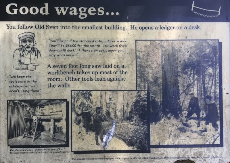
"You'll be paid the standard rate, a dollar a day. That'll be $26.00 for the month. You work from dawn until dark. If there's an early moon you may work longer."
"We keep the tools here in the office when we aren't using them."
A seven foot long saw laid on a workbench takes up most of the room. Other tools lean against the walls.
Photo caption:
Man sharpening a saw--probably in the camp office.
The exact location of the office for this camp is not known.
Erected by USDA Forest Service, Minnesota Department of Transportation and Lake County.
Topics. This historical marker is listed in this topic list: Horticulture & Forestry.
Location. 47° 39.541′ N, 91° 36.133′ W. Marker is near Isabella, Minnesota, in Lake County. It can be reached from County Road 2 0.2 miles south of State Route 1. Touch for map. Marker is in this post office area: Isabella MN 55607, United States of America. Touch for directions.
Regionally, this marker is on the Boundary Waters Canoe Area Wilderness,
this page online
Other nearby markers. At least one other marker is within walking distance of this marker: The Year is 1906 (about 500 feet away, measured in a direct line).
Additional keywords. Logging
Credits. This page was last revised on August 6, 2020. It was originally submitted on July 17, 2020, by Connor Olson of Menomonee Falls, Wisconsin. This page has been viewed 264 times since then and 8 times this year. Photos: 1. submitted on July 17, 2020, by Connor Olson of Menomonee Falls, Wisconsin. 2. submitted on August 5, 2020, by Connor Olson of Menomonee Falls, Wisconsin. • Mark Hilton was the editor who published this page.
Editor’s want-list for this marker. A wide shot of the marker and its surroundings • Can you help?
