Near Weatherly in Carbon County, Pennsylvania — The American Northeast (Mid-Atlantic)
A Revolution in Canal Technology
1838-1862
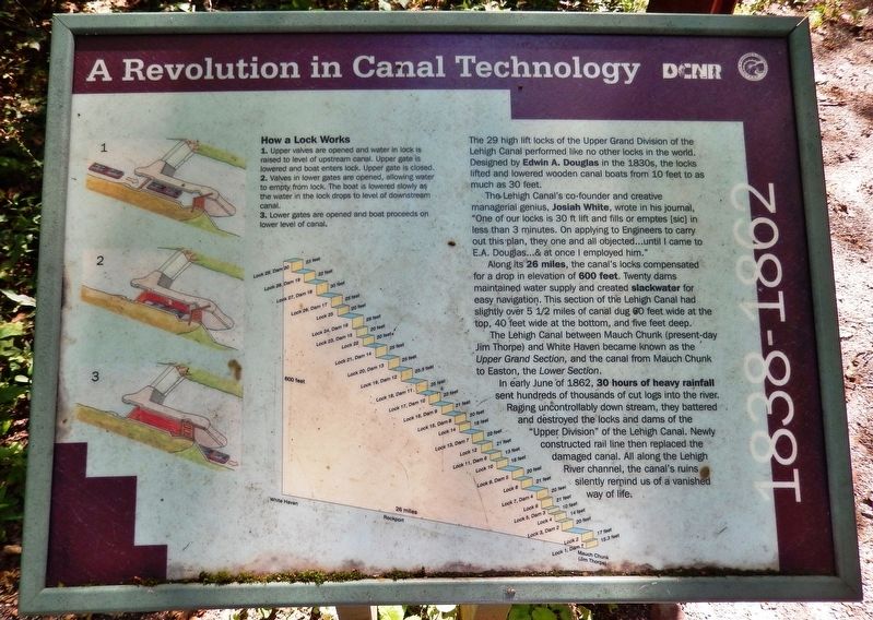
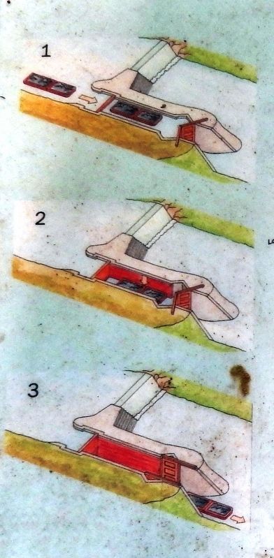
How a Lock Works
1. Upper valves are opened and water in lock is raised to level of upstream canal. Upper gate is lowered and boat enters lock. Upper gate is closed.
2. Valves in lower gates are opened, allowing water to empty from lock. The boat is lowered slowly as the water in the lock drops to level of downstream canal.
3. Lower gates are opened and boat proceeds on lower level of canal.
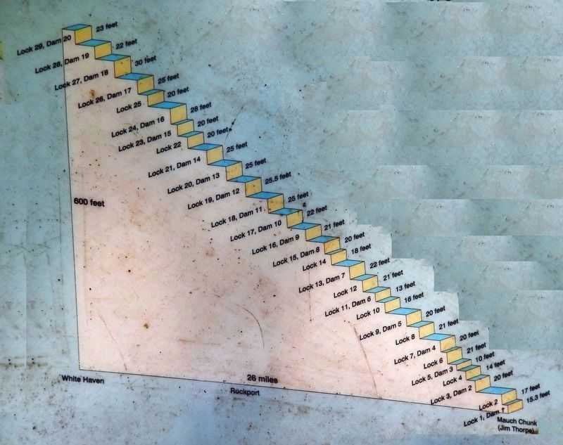
The 29 high lift locks of the Upper Grand Division of the Lehigh Canal performed like no other locks in the world. Designed by Edwin A. Douglas in the 1830s, the locks lifted and lowered wooden canal boats from 10 feet to as much as 30 feet.
The Lehigh Canal's co-founder and creative managerial genius, Josiah White, wrote in his journal, "One of our locks is 30 ft lift and fills or emptes [sic] in less than 3 minutes. On applying to Engineers to carry out this plan, they one and all objected... until I came to E.A. Douglas... & at once I employed him."
Along its 26 miles, the canal's locks compensated for a drop in elevation of 600 feet. Twenty dams maintained water supply and created slackwater for easy navigation. This section of the Lehigh Canal had slightly over 5½ miles of canal dug 60 feet wide at the top, 40 feet wide at the bottom, and five feet deep.
The Lehigh Canal between Mauch Chunk (present-day Jim Thorpe) and White Haven became known as the Upper Grand Section, and the canal from Mauch Chunk to Easton, the Lower Section.
In early June of 1862, 30 hours of heavy rainfall sent hundreds of thousands of cut logs into the river. Raging uncontrollably down stream, they battered and destroyed the locks and dams of the "Upper Division" of the Lehigh Canal. Newly constructed rail line then replaced the damaged canal. All along the Lehigh River channel, the canal's ruins silently remind us of a vanished way of life.
Erected by Pennsylvania Department of Conservation and Natural Resources.
Topics and series. This historical marker is listed in these topic lists: Disasters • Waterways & Vessels. In addition, it is included in the Lehigh Canal series list. A significant historical month for this entry is June 1862.
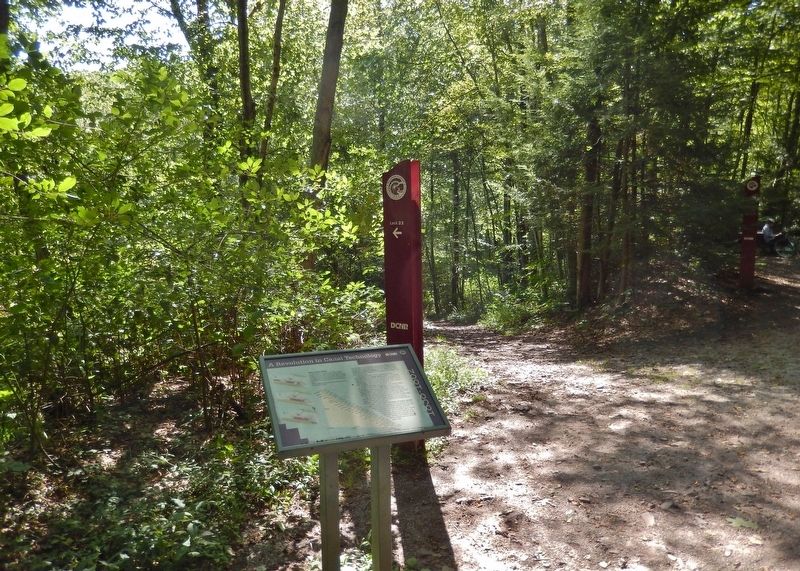
Location. 40° 59.319′ N, 75° 42.827′ W. Marker is near Weatherly, Pennsylvania, in Carbon County. Marker can be reached from Rockport Road, one mile east of South Lehigh Gorge Drive. Marker is located along the Lehigh Gorge Trail (Delaware and Lehigh Trail), in Lehigh Gorge State Park, about 3 miles northeast of the Rockport trailhead and parking lot. Touch for map. Marker is in this post office area: Weatherly PA 18255, United States of America. Touch for directions.
Other nearby markers. At least 8 other markers are within 5 miles of this marker, measured as the crow flies. Disaster at Mud Run (here, next to this marker); Engineering Marvel (about 400 feet away, measured in a direct line); From Rails to Trails (approx. 2.6 miles away); Lehigh Gorge State Park (approx. 2.6 miles away); Audubon Spoke for the Trees (approx. 2.6 miles away); Railroad Intersection (approx. 3˝ miles away); River Ran Black (approx. 4.2 miles away); a different marker also named River Ran Black (approx. 4.2 miles away). Touch for a list and map of all markers in Weatherly.
More about this marker. There are two identical instances of this marker on the Lehigh Gorge Trail. In addition to this one, there is a duplicate located 13 miles farther south at Oxbow Bend. Access to the markers is via bicycle, horseback, kayak/canoe, or foot.
Also see . . .
1. Lehigh Canal. In 1830, 303 tons of anthracite moved down the canal and by 1839, the peak year of the canal, 6,638 tons were hauled. As the railroad provided even lower costs after 1870 the canal lost much of its earlier importance. The Great Depression effectively ended the operations of the canal and in 1931 shipping on the canal stopped. Along the length of the canal are the remains of its 76 locks, eight guard locks, 28 dams, six aqueducts, locktenders houses, and canal villages. (Submitted on July 24, 2020, by Cosmos Mariner of Cape Canaveral, Florida.)
2. The Lehigh Canal. The Lehigh Canal was known as a “towpath canal” as a towpath ran parallel to the canal and was located on the west bank of the canal, between the canal and the river. Two mules were used to pull each canal boat. The mules were driven by a mule tender that walked along behind the mules to keep them moving and to attend to their needs. More often than not, the individual attending to the mules was the young son of the “canawler”, as the boatmen were called. Mules pulled barges at a speed of 1½ to 3 miles per hour. (Submitted on July 24, 2020, by Cosmos Mariner of Cape Canaveral, Florida.)
3. Lehigh Canal (Wikipedia). The canal's collapse began when a wet spring in 1862 repeatedly overfilled embankment dam reservoirs until the dam above White Haven failed, triggering a cascade of failing dams in a flood on June 4. Between 100 or 200 lives were lost in the villages and canal works below, the number varying by source. The Pennsylvania legislature forbade the rebuilding of the upper canal. The canal was used for transportation until the 1940s, and it was North America's last fully functioning towpath canal. In 1962, most of it was sold to private and public organizations for recreational
use. (Submitted on July 24, 2020, by Cosmos Mariner of Cape Canaveral, Florida.)
Credits. This page was last revised on July 24, 2020. It was originally submitted on July 23, 2020, by Cosmos Mariner of Cape Canaveral, Florida. This page has been viewed 165 times since then and 26 times this year. Photos: 1, 2, 3, 4, 5. submitted on July 24, 2020, by Cosmos Mariner of Cape Canaveral, Florida.


