Elkton in Cecil County, Maryland — The American Northeast (Mid-Atlantic)
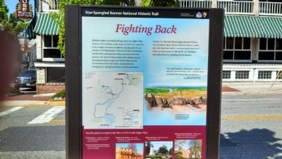
Fighting Back
Star-Spangled Banner National Historic Trail
British raiders traveled along rivers to Upper Bay towns in 1813. Elkton, at the head of Elk River, expected to be a target, because it could be a landing site for an advance on Philadelphia. Citizens of Elkton built three earthen forts and placed a chain across the river for defense. On April 29 they fended off a British assault. Focusing on easier targets, the British then struck Frenchtown, Havre de Grace, Fredericktown, Georgetown and Queenstown in quick succession.
On July 12, 1814, the British again attacked Elkton. The defenders "gave them in all eleven guns, so well directed, that they hastily...retreated down the river..." Only one other place in Maryland --St. Michaels--succeeded twice in repulsing British attacks.
"Two small batteries...in the town...opened their fire upon the barges, and...compelled them to retreat with considerable precipitation..."
Report on Elkton Skirmish in Alexandria Gazette, August 18, 1813
Nearby places to explore the War of 1812 in the Upper Bay:
Charlestown - Yielded to the British to avoid destruction of the town; period buildings
Lower Susquehanna Scenic Byway - 33-mile driving route from Havre de Grace to Perryville
Historic Elk Landing - Site of Fort Hollingsworth, a defensive earthwork that protected Elkton
Havre de Grace - Several sites that survived a British raid
Mount Harmon Plantation - 18th-century residence and tobacco prize house; Education and Discovery Center
Drawing
Fort Hollingsworth was one of the earthwork forts that successfully defended Elkton form two British attacks.
Topics and series. This historical marker is listed in this topic list: War of 1812. In addition, it is included in the Star Spangled Banner National Historic Trail series list. A significant historical date for this entry is April 29, 1812.
Location. 39° 36.471′ N, 75° 49.782′ W. Marker is in Elkton, Maryland, in Cecil County. Marker can be reached from the intersection of Main Street and North Street (Maryland Route 268), on the left when traveling east. This marker is part of a 3-sided structure (War in the Chesapeake; Fighting Back; "O! say can you see..."), with War in the Chesapeake being the one visible to traveler on Main Street, and we move counterclockwise to reach the subject marker. The marker is at NE corner of the intersection. Touch for map. Marker is in this post office area: Elkton MD 21921, United States of America. Touch for directions.
Other nearby markers. At least 8 other markers are within walking distance of this marker. "O! say can you see..." (here, next to this marker); War in the Chesapeake (here, next to this marker); Elkton (a few steps from this marker); Cecil Whig (within shouting distance of this marker); Michael Rudulph (about 400 feet away, measured in a direct line); Elkton, Wedding Capital of the East (about 400 feet away); Mitchell House (about 500 feet away); “Partridge Hill” (about 500 feet away). Touch for a list and map of all markers in Elkton.
Credits. This page was last revised on August 3, 2020. It was originally submitted on May 19, 2014, by Bill Pfingsten of Bel Air, Maryland. This page has been viewed 802 times since then and 22 times this year. Last updated on August 3, 2020, by Carl Gordon Moore Jr. of North East, Maryland. Photos: 1, 2. submitted on May 19, 2014, by Bill Pfingsten of Bel Air, Maryland.

