Huttonsville in Randolph County, West Virginia — The American South (Appalachia)
Huttonsville
On the Eve of Battle
— Jones-Imboden Raid —
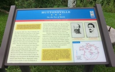
(Preface): On April 20, 1863, Confederate Gens. William E. “Grumble” Jones and John D. Imboden began a raid from Virginia through present-day West Virginia against the Baltimore and Ohio Railroad. Taking separate routes, they later reported that they marched 1,100 miles, fought several engagements, captured 100 Federals, seized about 1,200 horses and 4,000 cattle, and burned 4 turnpike bridges, more than 20 railroad bridges, 2 trains, and 150,000 barrels of oil. Most bridges were soon repaired. Confederate losses were slight. By May 26, both commands had returned to Virginia’s Shenandoah Valley.
On April 23, 1863, Gen John D. Imboden and his 3,300 cavalrymen rested here in the Tygart Valley after marching from Bartow 23 miles southeast on the Staunton and Parkersburg Turnpike. En route, they had waded the frigid, slush-filled Greenbrier River and then crossed Cheat Mountain where deep snow had fallen the night before. Now they prepared to attack Beverly.
Imboden was uncertain how many Federals were at the town and whether or not they knew of his impending attack. Capt. Joseph French Harding, who had attended school at the Huttonsville Academy, led a scouting party to the town. As they returned at dawn on April 24, Harding’s men encountered the Randolph County sheriff, Jesse Frank Phares, desperately riding north on the turnpike to warn the Federals at Beverly. Harding later wrote, “{I} ran on to the road and fired directly after him. We knew at the time that he was wounded, but he pluckily kept his saddle until reaching the Federal pickets at the bridge about two miles distant, and there gave them their first information of our advance.”
Harding reported that there were 1,100 Federal soldiers in Beverly. Imboden had already ordered his troops to start the twelve-mile march to the town. He divided his command into two columns near the present site of Dailey, advancing down both sides of the Tygart River. Thick fog in the valley obscured their movements until 1 P.M. By 5 P.M., the Federals had started to retreat from Beverly to Philippi.
(Sidebar): The 25th and 31st Virginia Infantry regiments were formed here at Huttonsville on June 14, 1861. They were part of Confederate Gen. Robert S. Garnett's Army of the Northwest. When Imboden wrote to Gen. Robert E. Lee in March 1863 of his plans for an invasion of northwestern Virginia, he asked for these regiments: "These two old regiments are from the northwest ... and would fight like tigers the vandals who have so long domineered over their helpless families." On April 9, Lee ordered the two regiments from eastern Virginia by railroad to Staunton to join the raiders.
Erected by West Virginia Civil War Trails.
Topics and series. This historical marker is listed in this topic list: War, US Civil. In addition, it is included in the West Virginia Civil War Trails series list. A significant historical month for this entry is April 1790.
Location. 38° 42.648′ N, 79° 58.794′ W. Marker is in Huttonsville, West Virginia, in Randolph County. Marker is at the intersection of Railroad Street (U.S. 219) and U.S. 250 on Railroad Street. Touch for map. Marker is at or near this postal address: 180 Railroad St, Huttonsville WV 26273, United States of America. Touch for directions.
Other nearby markers. At least 8 other markers are within 8 miles of this marker, measured as the crow flies. A different marker also named Huttonsville (here, next to this marker); Bishop Asbury (approx. half a mile away); Old Brick Church (approx. one mile away); Elkwater / Col. J. A. Washington (approx. 6.2 miles away); Camp Elkwater (approx. 6.2 miles away); Tygart Valley Homesteads (approx. 6.8 miles away); West Virginia Historic New Deal / CCC Trail (approx. 6.8 miles away); U.S. Homestead (approx. 7.6 miles away). Touch for a list and map of all markers in Huttonsville.
Credits. This page was last revised on August 23, 2020. It was originally submitted on September 10, 2012, by Don Morfe of Baltimore, Maryland. This page has been viewed 882 times since then and 35 times this year. Last updated on August 21, 2020, by Carl Gordon Moore Jr. of North East, Maryland. Photos: 1, 2. submitted on September 10, 2012, by Don Morfe of Baltimore, Maryland. • Devry Becker Jones was the editor who published this page.

