Near Becket in Berkshire County, Massachusetts — The American Northeast (New England)
A Monument to the Automotive Age
"A Monument to the Automobile Age
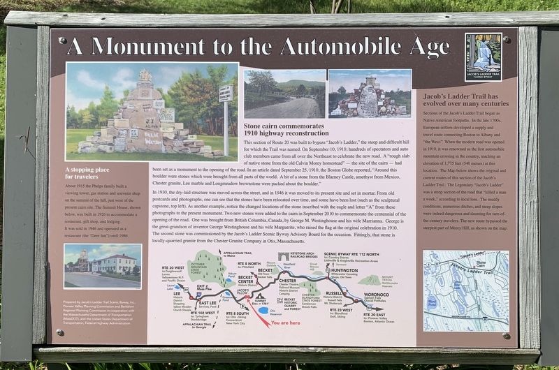
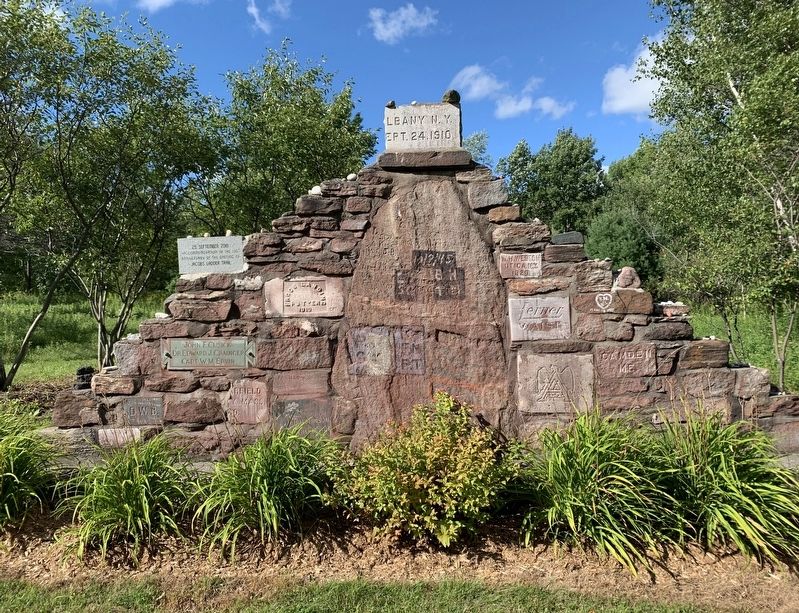
This section of Route 20 was built to bypass “Jacob's Ladder,” the steep and difficult hill for which the Trail was named. On September 10, 1910, hundreds of spectators and auto club members came from all over the Northeast to celebrate the new road. A "rough slab of native stone from the old Calvin Morey homestead" the site of the cairn – had been set as a monument to the opening of the road. In an article dated September 25, 1910, the Boston Globe reported, "Around this boulder were stones which were brought from all parts of the world. A bit of a stone from the Blarney Castle, amethyst from Mexico, Chester granite, Lee marble and Longmeadow brownstone were packed about the boulder."
In 1930, the dry-laid structure was moved across the street, and in 1946 it was moved to its present site and set in mortar. From old postcards and photographs, one can see that the stones have been relocated over time, and some have been lost (such as the sculptural capstone, top left). As another example, notice the changed locations of the stone inscribed with the eagle and letter “A” from these photographs to the present monument. Two new stones were added to the cairn in September 2010 to commemorate the centennial of the opening of the road. One was brought from British Columbia, Canada, by George M. Westinghouse and his wife Marrianna. George is the great-grandson of inventor George Westinghouse and his wife Marguerite, who raised the flag at the original celebration in 1910. The second stone was commissioned by the Jacob's Ladder Scenic Byway Advisory Board for the occasion. Fittingly, that stone is locally-quarried granite from the Chester Granite Company in Otis, Massachusetts.
Right Inset
Jacob's Ladder Trail has evolved over many centuries
Sections of the Jacob's Ladder Trail began as Native American footpaths. In the late 1700s, European settlers developed a supply and travel route connecting Boston to Albany and "the West.” When the modern road was opened in 1910, it was renowned as the first automobile mountain crossing in the country, reaching an elevation of 1,775 feet (540 meters) at this location. The Map below shows the original and current routes of this section of the Jacob's Ladder Trail. The Legendary "Jacob's Ladder" was a steep section of the road that "killed a man a week,” according to local lore. The muddy conditions, numerous ditches, and steep slopes were indeed dangerous and daunting for turn-of-the-century travelers. The new route bypassed the steepest part of Morey Hill, as shown on the map.
Left Inset
A stopping place for travelers
About 1915 the Phelps family built a viewing tower, gas station and souvenir shop on the summit of the hill, just west of the present cairn site. The Summit House, shown below, was built in 1926 to accommodate a restaurant, gift shop, and lodging. It was sold in 1946 and operated as a restaurant (the "Deer Inn") until 1986.
Erected by Jacob's Ladder Trail Scenic Byway, Inc., Pioneer Valley Planning Commission, Berkshire Regional Planning Commission, MassDOT, and the US DOT, Federal Highway Administration.
Topics. This historical marker is listed in this topic list: Roads & Vehicles. A significant historical date for this entry is September 10, 1910.
Location. 42° 15.521′ N, 73° 5.151′ W. Marker is near Becket, Massachusetts, in Berkshire County. Marker is at the intersection of Jacobs Ladder Road (U.S. 20) and Johnson Road, on the right when traveling west on Jacobs Ladder Road. Touch for map. Marker is in this post office area: Becket MA 01223, United States of America. Touch for directions.
Other nearby markers. At least 8 other markers are within 5 miles of this marker, measured as the crow flies. First Congregational Church (approx. 4.4 miles away); Otis Veterans Monument (approx. 4.4 miles away); Town of Becket Veterans Memorial (approx. 5 miles away); Town of Becket World War II Memorial (approx. 5 miles away); Town of Becket World War Memorial (approx. 5 miles away); Town of Becket Korea and Vietnam Memorial (approx. 5 miles away); Monroe E. Ballou (approx. 5 miles away); Railroad (approx. 5 miles away). Touch for a list and map of all markers in Becket.
Credits. This page was last revised on September 2, 2020. It was originally submitted on August 30, 2020, by Steve Stoessel of Niskayuna, New York. This page has been viewed 620 times since then and 113 times this year. Photos: 1, 2. submitted on August 30, 2020, by Steve Stoessel of Niskayuna, New York. • Michael Herrick was the editor who published this page.

