Near Watrous in Mora County, New Mexico — The American Mountains (Southwest)
Lasting View
Santa Fe National Historic Trail
— Fort Union National Monument —
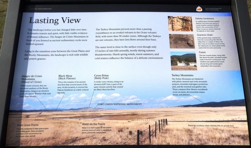
Lying in the transition zone between the Great Plains and the Rocky Mountains, the landscape is rich with wildlife and prairie grasses.
The Turkey Mountains present more than a passing resemblance to an eroded volcano in the Ocate volcanic field, with more than 50 cinder cones. Although the Turkeys are not volcanic, they have lava flows around their base.
The water level is close to the surface even though only 15 inches of rain falls annually, mostly during summer thunderstorms. Harsh spring winds, warm summers, and cold winters influence the balance of a delicate environment.
Sangre de Cristo Mountains
(Blood of Christ)
Often snow-covered, they are the most southern of the Rocky Mountains, rising to an elevation 13,161 feet at Wheeler Peak near Taos, New Mexico.
Black Mesa
(Black Plateau)
This is the remains of an ancient lava flow that covered much of the area. At this location, it covered the Dakota Sandstone as a dark-colored cap rock.
Cerro Pelon
(Baldy Peak)
A cinder cone volcano, rising to an elevation 8,871 feet, is part of the same volcanic activity that created the Black Mesa lava flow.
Short Grass Prairie
Primarily composed of blue-grama grass and buffalo grass, these grasslands provided a lush environment for pronghorn, deer, and elk.
Water on the Prairie
Water is in short supply on the prairie and any source of water is valuable to plants, animal life, and humans.
Dakota Sandstone
An uplifted layer of ancient seabed deposits, this stone was used as a crucial weather-resistant building block in the construction of Fort Union. Its porous nature enhanced its capacity to store water.
Graneros Shale
A fine-grained shale, washed out from the surrounding hills, fills the valley floor to a depth of about 150 feet. It was an excellent source of clay for making the sun dried adobe bricks used at the fort and community.
Forest
The tree covered slopes, rising 2000 feet above the plain, provided lumber used in the fort’s construction. Fort residents also gathered fire wood all year long and hunted game seasonally in the mountains.
Turkey Mountains
The Turkey Mountains are blanketed with piñon, oneseed and rocky mountain junipers, mountain mahogany, ponderosa pine, and the wavyleaf and gambel oaks. These common New Mexico woodlands occur on warm, dry mountain slopes, mesas, and plateaus.
Erected by Santa Fe Trail Association.
Topics and series. This historical marker is listed in this topic list: Natural Features. In addition, it is included in the Santa Fe Trail series list.
Location. 35° 50.65′ N, 105° 0.082′ W. Marker is near Watrous, New Mexico, in Mora County. Marker can be reached from New Mexico Route 161, 2.6 miles north of Interstate 25, on the left when traveling north. Marker is the leftmost of three related interpretive panels at this location. Access is via a 3/10 mile walk northward along path from the pull-out and parking area on New Mexico Route 161. Touch for map. Marker is in this post office area: Watrous NM 87753, United States of America. Touch for directions.
Other nearby markers. At least 8 other markers are within 4 miles of this marker, measured as the crow flies. Tides of Change (here, next to this marker); A Show of Strength (here, next to this marker); From Indigenous Trail to International Highway (approx. 0.6 miles away); Intersection of History (approx. 0.6 miles away); A New Community Sprouts Roots (approx. 0.6 miles away); La Junta (approx. 3.2 miles away); Fort Union Arsenal / Fort Union National Monument (approx. 3.7 miles away); Watrous - Western Junction of the Santa Fe Trail (approx. 3.8 miles away). Touch for a list and map of all markers in Watrous.
Related markers. Click here for a list of markers that are related to this marker. Fort
Union National Monument
Credits. This page was last revised on September 29, 2020. It was originally submitted on September 27, 2020, by Cosmos Mariner of Cape Canaveral, Florida. This page has been viewed 112 times since then and 9 times this year. Photos: 1, 2, 3. submitted on September 28, 2020, by Cosmos Mariner of Cape Canaveral, Florida.


