Near Watrous in Mora County, New Mexico — The American Mountains (Southwest)
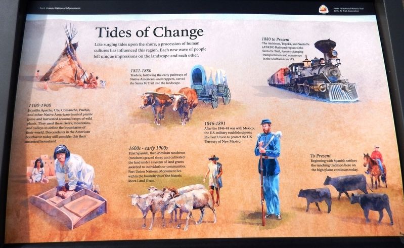
Tides of Change
Santa Fe National Historic Trail
— Fort Union National Monument —
1100-1900
Jicarilla Apache, Ute, Comanche, Pueblo, and other Native Americans hunted prairie game and harvested seasonal crops of wild plants. They used these rivers, mountains, and valleys to define the boundaries of their world. Descendants in the American Southwest today still consider this their ancestral homeland.
1600s-early 1900s
First Spanish, then Mexican rancheros (ranchers) grazed sheep and cultivated the land under a system of land grants awarded to individuals or communities. Fort Union National Monument lies within the boundaries of the historic Mora Land Grant.
1821-1880
Traders, following the early pathways of Native Americans and trappers, carved the Santa Fe Trail into the landscape.
1846-1891
After the 1846-48 war with Mexico, the U.S. military established posts like Fort Union to protect the U.S. Territory of New Mexico.
1880 to Present
The Atchison, Topeka, and Santa Fe (AT&SF) Railroad replaced the Santa Fe Trail, forever changing transportation and commerce in the southwestern U.S.
To Present
Beginning with Spanish settlers the ranching tradition here on the high plains continues today.
Erected by Santa Fe Trail Association.
Topics and series. This historical marker is listed in these topic lists: Forts and Castles • Native Americans • Railroads & Streetcars • Settlements & Settlers. In addition, it is included in the Santa Fe Trail series list.
Location. 35° 50.65′ N, 105° 0.08′ W. Marker is near Watrous, New Mexico, in Mora County. Marker can be reached from New Mexico Route 161, 2.6 miles north of Interstate 25, on the left when traveling north. Marker is the center of three related interpretive panels at this location. Access is via a 3/10 mile walk northward along path from the pull-out and parking area on New Mexico Route 161. Touch for map. Marker is in this post office area: Watrous NM 87753, United States of America. Touch for directions.
Other nearby markers. At least 8 other markers are within 4 miles of this marker, measured as the crow flies. Lasting View (here, next to this marker); A Show of Strength (here, next to this marker); From Indigenous Trail to International Highway (approx. 0.6 miles away); Intersection of History (approx. 0.6 miles away); A New Community Sprouts Roots (approx. 0.6 miles away); La Junta (approx.
3.2 miles away); Fort Union Arsenal / Fort Union National Monument (approx. 3.7 miles away); Watrous - Western Junction of the Santa Fe Trail (approx. 3.8 miles away). Touch for a list and map of all markers in Watrous.
Related markers. Click here for a list of markers that are related to this marker. Fort Union National Monument
Also see . . .
1. Mora County, New Mexico (Wikipedia). Hispano settlers had occupied lands within the Mora Valley without legal title ever since Governor Juan Bautista de Anza of Nuevo México made peace with the Comanches in the late 18th century. Mora valley was more formally and broadly settled in 1835 when families each received a strip of property by a September 28, 1835, land grant of Centralist Republic of Mexico Governor of New Mexico Albino Pérez. (Submitted on September 28, 2020, by Cosmos Mariner of Cape Canaveral, Florida.)
2. A History of Fort Union. The general area encompassing Fort Union National Monument has been used historically by travelers along what would become the Santa Fe Trail. They include various American Indian groups of several different tribes, Spanish explorers and settlers, New Mexicans both travelling through the area and using it for grazing for both sheep and cattle, Frenchmen seeking riches in Santa Fe and New Mexico, Americans benefitting from trade with New Mexico, an army of invasion, civilian and military personnel associated with the three Fort Unions and the Santa Fe Trail, and ranchers. (Submitted on September 28, 2020, by Cosmos Mariner of Cape Canaveral, Florida.)
3. Atchison, Topeka and Santa Fe Railway (Wikipedia). The Atchison, Topeka & Santa Fe Railway (AT&SF) was chartered on February 11, 1859, to join Atchison and Topeka, Kansas, with Santa Fe, New Mexico. AT&SF reached Albuquerque in 1880; Santa Fe, the original destination of the railroad, found itself on a short branch from Lamy, New Mexico. (Submitted on September 28, 2020, by Cosmos Mariner of Cape Canaveral, Florida.)
Credits. This page was last revised on September 29, 2020. It was originally submitted on September 27, 2020, by Cosmos Mariner of Cape Canaveral, Florida. This page has been viewed 132 times since then and 9 times this year. Photos: 1, 2. submitted on September 28, 2020, by Cosmos Mariner of Cape Canaveral, Florida.

