Sandy Hook in Washington County, Maryland — The American Northeast (Mid-Atlantic)
Naval Battery
Photographed by Craig Swain, September 22, 2007
1. Naval Battery Marker
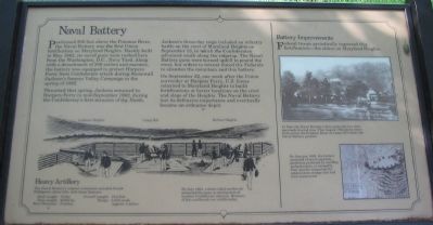
Positioned 300 feet above the Potomac River the Naval Battery was the first Union fortification on Maryland Heights. Hastily built in May 1862, its naval guns were rushed here from the Washington, D.C., Navy Yard. Along with a detachment of 300 sailors and marines, the battery was equipped to protect Harpers Ferry from Confederate attack during Stonewall Jackson's famous Valley Campaign in the spring of 1862.
Thwarted that spring, Jackson returned to Harpers Ferry in mid-September 1862, during the Confederacy's first invasion of the North. Jackson's three-day siege included an infantry battle on the crest of Maryland Heights on September 13, in which the Confederates advanced south along the ridgetop. The Naval Battery guns were turned uphill to pound the crest, but orders to retreat forced the Federals to abandon the mountain and this battery.
On September 22, one week after the Union surrender at Harpers Ferry, U.S. forces returned to Maryland Heights to build fortifications at better locations on the crest and slope of the Heights. The Naval Battery lost its defensive importance and eventually became an ordnance depot.
Topics.
this page online
Location. 39° 19.916′ N, 77° 43.73′ W. Marker is in Sandy Hook, Maryland, in Washington County. It can be reached from Sandy Hook Road. Located on the hiking trail of Maryland Heights, at the second trail wayside. Touch for map. Marker is in this post office area: Knoxville MD 21758, United States of America. Touch for directions.

Regionally, this marker is in Western Maryland. It is also in the American Mid-Atlantic, in Appalachia, and specifically in Northern Appalachia. Globally, it is in North America, the Western Hemisphere, the Western World, and the Anglosphere. Historically, it finds itself in what was once one of the original Thirteen Colonies.
Other nearby markers. At least 8 other markers are within walking distance of this marker: Hiking Maryland Heights (about 500 feet away, measured in a direct line); Maryland Heights - Mountain Fortress of Harpers Ferry (approx. 0.2 miles away); Exploring Maryland Heights (approx. ¼ mile away); Making a Mountain Citadel (approx. ¼ mile
Photographed by Craig Swain, September 22, 2007
2. Illustration of the Naval Battery
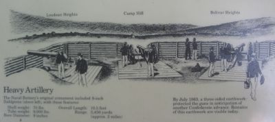
Note the notations of distant geographic landmarks in the upper portion of the drawing. The drawing appears to show one Dahlgren and two field artillery pieces. The Dahlgren, as mentioned a navy weapon, was usually seen mounted on a low profile naval carriage (as on the left).
More about this marker. On the lower left of the marker is a drawing depicting the battery in use:
Heavy Artillery
The Naval Battery's original armament included 9-inch Dahlgrens (above left), with these features:
Shell weight: 70lbs Overall Length: 10.5 feet
Tube weight: 9,000 lbs Range: 3,450 yards (approx. 2 miles)
Bore Diameter: 9 inches
"By July 1863, a three-sided earthwork protected the guns in anticipation of another Confederate advance. Remains of this earthwork are visible today."
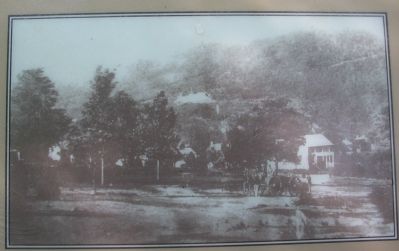
On the upper right a photo shows, "At first, the Naval Battery's three guns sat on a clear, manmade leveled area. This August 1862 photo taken from across the Potomac River at Camp Hill shows the Naval Battery position."
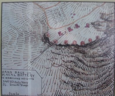
On the lower right is an engineering elevation of the battery, "By January 1863, the battery consisted of seven separate platforms protected
Photographed by Craig Swain, September 22, 2007
3. Photograph of the Naval Battery
Camp Hill, mentioned in the caption as the photographer's location, is presently the grounds of Storer College Campus. The lighter shaded section of Maryland Heights in the background, almost center of the photo, is identified as the location of the Naval Battery in the photograph.
Regarding Naval Battery. This marker is one of a set along the National Park Service's trail to the top of Maryland Heights.
Photographed by Craig Swain, September 22, 2007
4. Engineering Diagram of the Battery
Note the annotation of "30-pdr Rif Dalg Navy" and "24 smooth siege" on the lower left. The 30-pdr Rifled Dahlgren was a far different piece than the 9-inch smoothbore Dahlgren. So either the draftsman was indicating a change in naval supplied armament, or was confused as to the actual identification. The 24-pdr Siege could indicate either a standard Army siege and garrison gun or howitzer.
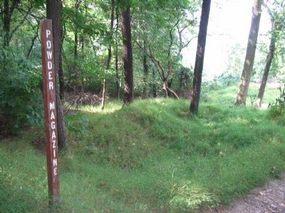
Photographed by Craig Swain, September 22, 2007
5. Battery's Powder Magazine
Later when the battery was converted to a depot, this was expanded.

Photographed by Craig Swain, September 22, 2007
6. Naval Battery Interior
As it looks today, traces of the battery are easy to pick out. This is the remains of a gun platform overlooking the Potomac.

Photographed by Craig Swain, September 22, 2007
7. Harper Cemetery from the Naval Battery
Trees obstruct a view of Camp Hill directly, but this view would be generally opposite that presented in the wartime photograph. And the view from atop Maryland Heights is worth the three hour hike.

Photographed by Tom Bosse, September 14, 2025
8. Naval Battery Marker
Credits. This page was last revised on December 8, 2025. It was originally submitted on January 27, 2008. This page has been viewed 2,963 times since then and 102 times this year. Last updated on October 3, 2020, by Bradley Owen of Morgantown, West Virginia. Photos: 1, 2, 3, 4, 5, 6, 7. submitted on January 27, 2008, by Craig Swain of Leesburg, Virginia. 8. submitted on December 6, 2025, by Tom Bosse of Jefferson City, Tennessee. • J. Makali Bruton was the editor who published this page.
