Easton in Northampton County, Pennsylvania — The American Northeast (Mid-Atlantic)
Easton's Abbot Street Area
1832 - 1880
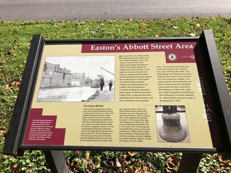
Iron wasn't the only thing being manufactured along Section 8 of the Lehigh Navigation in the 19th century. Only one year after opening the Lehigh Navigation in 1829, Josiah White tapped his creative mind and proclivity to use water as a source of power and revenue, and opened the Abbott Street Industrial Area at the eastern end of Section 8 in South Easton. The Abbott Street industrial complex was developed by the Lehigh Coal and Navigation Company to utilize the abundant water power to both the canal and Lehigh River. It became the prime industrial area of South Easton and one of America's first industrial parks. The earliest businesses were a saw mill and grist mill, a rifle factory, and a whiskey still maker. The Rodenbaugh and Stewart wire works made the wire used to most of America's first suspension bridges. The close proximity of the Delaware and Morris canals meant the industries could easily ship their products to Philadelphia and New York, while the Lehigh Navigation provided them with anthracite to fuel their enterprises. Abbott Street reached its peak of development in 1875.
The Abbott Street industries included The Rodenbaugh and Stewart Wire Works, which manufactured fine iron wire that Amrican bridge icon, John A. Roebling, used in many of the early canal aqueducts he built for the Delaware and Hudson Canal Company. The company closed in the early 20th century.
The Cotton Mill Bell
One of the first industries to be affected by the Industrial Revolution was the manufacture of cotton yarn. Cotton mills needed both great amounts of water power to function and an economical means of transporting raw materials to their sites and finished goods to market. As a result, most mills were built along the banks of navigation systems. It is not surprising that among the earliest tenants of the Abbott Street Industrial ARea was a cotton mill. The bell pictured on the right hung in the tower of the McKeen and Raphael cotton mill, and rang for the beginning and end of each work day. Originally built in 1835 as the Swift & Breck spinning mill for making cotton yarn and candlewick, the mill was purchased in 1844 by Edward Quinn, who expanded the operation to a point, in 1870, where there were 300 employees and 266 looms. McKeen and Raphael purchased the mill in 1872 and by 1877 the mill was consuming 800,000 pounds of cotton and producing 2.5 million yards of cotton ticks and stripes. Water power could not drive machinery as fast or efficiently as steam engines, however, and the mill closed in the late 1880s.
Erected by City of Easton, Pennsylvania.
Topics. This historical marker is listed in these topic
Location. 40° 39.89′ N, 75° 14.279′ W. Marker is in Easton, Pennsylvania, in Northampton County. Marker is on Hugh Moore Park Road, 0.3 miles south of Hill Road, on the left when traveling south. Touch for map. Marker is at or near this postal address: 376 Hugh Moore Park Rd, Easton PA 18042, United States of America. Touch for directions.
Other nearby markers. At least 8 other markers are within walking distance of this marker. The Rise of Bethlehem Iron (within shouting distance of this marker); The Glendon Iron Works (about 400 feet away, measured in a direct line); Anthracite Iron - A Revolution Is Born (about 700 feet away); Mules and Men (about 800 feet away); From Mountain to Market (approx. 0.2 miles away); The Canaler's Life (approx. 0.2 miles away); It's a Short Commute (approx. 0.2 miles away); The Lehigh Canal (approx. 0.2 miles away). Touch for a list and map of all markers in Easton.
Credits. This page was last revised on October 6, 2020. It was originally submitted on October 6, 2020, by Devry Becker Jones of Washington, District of Columbia. This page has been viewed 318 times since then and 85 times this year. Photos: 1, 2. submitted on October 6, 2020, by Devry Becker Jones of Washington, District of Columbia.

