Near Lyle in Klickitat County, Washington — The American West (Northwest)
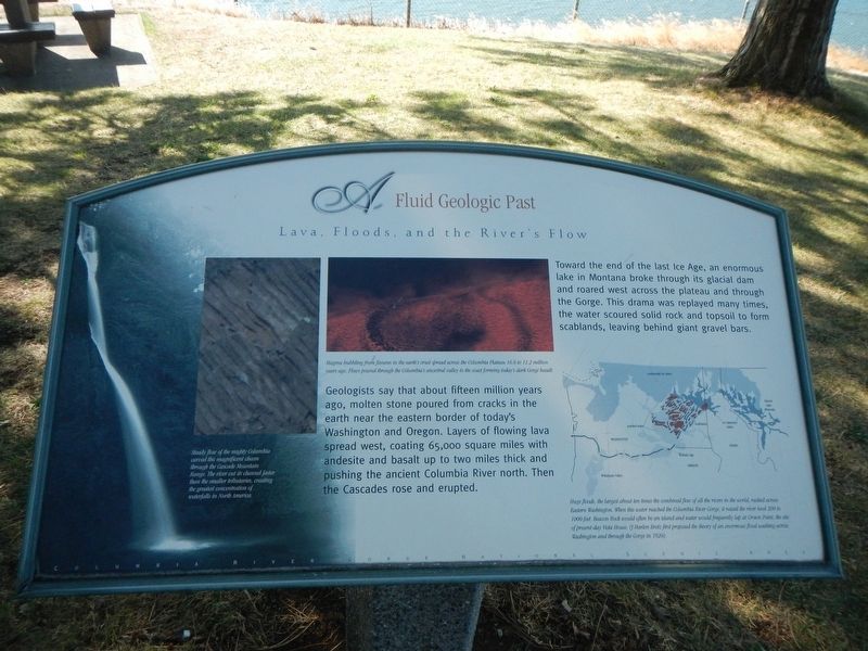
A Fluid Geologic Past
Lava Floods and the River Flow

Photographed By Barry Swackhamer, August 13, 2020
1. A Fluid Geologic Past Marker
Captions: (bottom left) Steady flow of the mighty Columbia carved this magnificent chasm through the Cascade Mountain Range. The river cuts its channel faster than the smaller tributaries, creating the greatest concentration of waterfalls in North America.; (center) Magma bubbling from fissures in the earth's crust spread across the Columbia Plateau 16.6 to 11.3 million years ago. Flow poured through the Columbia's ancestral valley to the coast forming today's dark Gorge basalt.; (map, lower right) Huge floods, the largest abut ten times the combined flow of all the rivers in the world, rushed across Eastern Washington. When this water reached the Columbia River Gorge, it raised the river level 200 to 1000 feet. Beacon Rock would often be and island and water would frequently lap at Crown Point, the site of present-day Vista House. (J. Harlen Bretz first proposed the theory of an enormous flood washing across Washington through the Gorge in 1920).
Toward the end of the last Ice Age, and enormous lake in Montana broke through its glacial dam and roared west across the plateau and through the Gorge. This drama was replayed many times, the water scoured solid rock and topsoil to form scablands, leaving behind giant gravel bars.
Erected by Columbia River Gorge National Scenic Area.
Topics. This historical marker is listed in this topic list: Natural Features.
Location. 45° 42.333′ N, 121° 19.439′ W. Marker is near Lyle, Washington, in Klickitat County. Marker can be reached from Lewis and Clark Highway (Washington Route 14) near Old Highway 8, on the right when traveling east. Touch for map. Marker is in this post office area: Lyle WA 98635, United States of America. Touch for directions.
Other nearby markers. At least 8 other markers are within 7 miles of this marker, measured as the crow flies. Transition Zones (within shouting distance of this marker); Memaloose—Island of the Dead (approx. 0.9 miles away in Oregon); Memaloose Rest Area Oregon Trail Kiosk (approx. one mile away in Oregon); Memaloose Overlook (approx. 1˝ miles away in Oregon); Rowena Crest - Ice Age Floods (approx. 2 miles away in Oregon); Rowena Crest - The Rowena Loops (approx. 2 miles away in Oregon); Mosier (approx. 3.8 miles away in Oregon); The History of the Columbia River Highway (approx. 6˝ miles away in Oregon).
More about this marker. This marker is located at the Chamberlain Lake Safety Rest Area.
Credits. This page was last revised on October 20, 2020. It was originally submitted on October 20, 2020, by Barry Swackhamer of Brentwood, California. This page has been viewed 145 times since then and 15 times this year. Photos: 1, 2. submitted on October 20, 2020, by Barry Swackhamer of Brentwood, California.
