Middletown in Frederick County, Virginia — The American South (Mid-Atlantic)
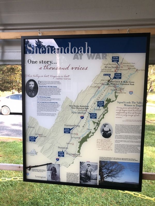
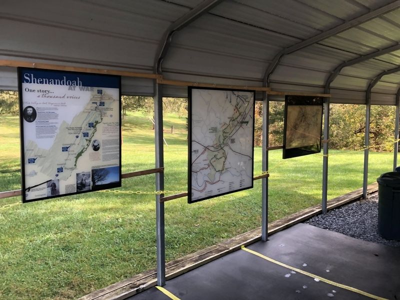
Shenandoah At War
One story… a thousand voices
If this Valley is lost, Virginia is lost!
—General Thomas "Stonewall" Jackson
During the American Civil War, control of the Shenandoah Valley was critical to the fate of Virginia and the Confederacy. Its fertile fields and strategic importance made it a valued pawn in this most uncivil war.
Stonewall Jackson's 1862 Valley Campaign
Confederate Gen. Thomas J. "Stonewall" Jackson took brilliant advantage of this landscape throughout his famous Valley Campaign. Vastly outnumbered, Jackson managed in less than three months march his army hundreds of miles and fight a series of engagements in a masterpiece of military art. Coming at a time when Southern forces confronted military pressure and defeat on seemingly every other front, including Union forces at the gates of Richmond, Jackson gave new hope to the young Confederacy.
Lee's 1863 Gettysburg Campaign
In 1863, Confederate Gen. Robert E. Lee used the Valley as an "avenue of invasion" as he moved north — and then, after his defeat at Gettysburg, as a route of retreat and a haven for his wounded.
1864: The Turning Point for the Shenandoah Valley
The Valley experienced war first-hand once again in 1864. A series of spring and summertime victories were the last Confederates would see in the Valley. Federal leaders turned a new commander, Gen. Philip H. Sheridan, and in the fall Sheridan delivered several stinging defeats, dashing Confederate hopes. And in what came to be known as "The Burning," Sheridan's Union army systematically destroyed much of the region's resources. Mills, barns, and crops were burned, livestock destroyed and the agricultural bounty of the Valley left in ruins.
By the end of 1864, the Union had permanent control of the Valley, and Stonewall Jackson's word proved prophetic. The war would end less than six months later at Appomattox.
Signal k nob: The Valley Witness to Tragedy
"Every piece of artillery, every wagon and tent and supporting line of troops were in easy range of our vision."
—Confederate Gen. John B. Gordon, observing from Signal Knob before the BAttle of Cedar Creek, October 1864
Observers on Signal Knob at the north tip of Massanutten Mountain were in a position to view battles and movements in three counties throughout the Civil War. The Massanutten is a 60-mile-long range that splits the Shenandoah Valley from Strasburg to Harrisonburg. Front Royal and Strasburg are located at narrows formed by the mountains and the two forks of the Shenandoah River. These choke points channeled opposing armies' movements and influenced
In 1862, Confederate Gen. "Stonewall" Jackson used Massanutten to screen movement northward, overwhelming a small Union garrison at Front Royal that was disconnected from the larger Federal force at Strasburg. Weakened, the northerners lost to Jackson again at Winchester two days later.
In 1863, the last Federal attempt to cut off Confederate Gen. Robert E. Lee's retreat after his defeat at Gettysburg failed at the Battle of Manassas Gap, east of Front Royal.
In the fall of 1864, Confederates under Gen. Jubal Early, having withdrawn south after being defeated by Gen. Philip Sheridan's Federals at Winchester were flanked and defeated again at Fisher's Hill. Enraged by Union destruction during The Burning, Early's outmanned cavalry became overaggressive and was routed by the Federals at Tom's Brook. Finally, Early used Signal Knob as a vantage point to plan a surprise attack at Cedar Creek—an assault that came very close to succeeding before Sheridan and the Federals rallied for the dramatic victory, one that effectively ended the major Confederate war effort in the Valley.
"Go back quick and tell him [Stonewall Jackson] that the Yankee Force is very small…Tell him I know, for I went through the camps and got it out of an officer."
— Belle Boyd, resident of Front Royal, before the Battle of Front Royal, May 23, 1862
[Captions:]
This sword was presented to Lt. John Hoyt, 29th Maine, by his fellow officers in January 1864. Nine months later he was killed in action at the Battle of Cedar Creek.
In late 1864, Union soldiers in Front Royal executed six captured Confederates who had been fighting under Confederate partisan leader Col. John Mosby [pictured]; Mosby vowed to execute an equal number of Federals in return. A Civil War Trails sign marks the site of the execution (site #16 on the map), and a monument in Prospect Hill Cemetery remembers the executed Confederates (site #13).
At the Battle of Fisher's Hill (September 21-22, 1864), Confederate Gen. Jubal Early locked the troops to fully man his imposing position, leaving him vulnerable to a flank attack by Union gen. Philip Sheridan's forces that drove Early's defenders from the field. (Site #23 on the map)
"Thence we went, sweeping down their lines like a western cyclone."
—Union Col. Thomas F. Wildes, Battle of Fisher's Hill
Topics. This historical marker is listed in this topic list: War, US Civil. A significant historical month for this entry is January 1864.
Location.
We have been informed that this sign or monument is no longer there and will not be replaced. This page is an archival view of what was.
Other nearby markers. At least 8 other markers are within walking distance of this location. The Shenandoah Valley / Battle of Cedar Creek, October 19, 1864 (here, next to this marker); Slowing the Advance (a few steps from this marker); Eve of Battle (within shouting distance of this marker); Stand of the Eighth Vermont (about 700 feet away, measured in a direct line); Cedar Creek (about 700 feet away); Signal Knob During the Civil War (approx. 0.2 miles away); a different marker also named Eve of Battle (approx. 0.2 miles away); Battle of Cedar Creek (approx. 0.2 miles away). Touch for a list and map of all markers in Middletown.
Credits. This page was last revised on October 22, 2023. It was originally submitted on October 24, 2020, by Devry Becker Jones of Washington, District of Columbia. This page has been viewed 219 times since then and 25 times this year. Last updated on October 24, 2020, by Bradley Owen of Morgantown, West Virginia. Photos: 1, 2. submitted on October 24, 2020, by Devry Becker Jones of Washington, District of Columbia. 3. submitted on October 22, 2023, by Bradley Owen of Morgantown, West Virginia. 4. submitted on October 24, 2020, by Devry Becker Jones of Washington, District of Columbia.


