Mosca in Alamosa County, Colorado — The American Mountains (Southwest)
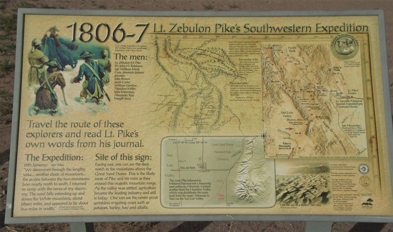
Lt. Zebulon Pike's Southwestern Expedition
1806-7
Inscription.
Travel the route of these explorers and read Lt. Pike’s own words from his journal.
U.S. Army Expedition to explore the United States new southwest boundary with New Spain.
The men:
Lt. Zebulon M. Pike
Dr. John H. Robinson
Sgt. William Meek
Corp. Jeremiah Jackson
privates:
John Brown
Jacob Carter
William Gordon
Theodore Miller
John Mountjoy
Alexander Roy
Freegift Stout
From the careful logbooks by early explorers like Lewis & Clark and Zebulon Pike, the mapmakers of Washington were kept busy creating new images of the mostly unknown Rocky Mountains. This original map was published in 1807.
November 27th:
“The unbounded prairie was overhung with clouds, which appeared like the ocean in a storm ... the thermometer ... here fell to 4° below 0.”
1806 (Pike)
December 25th:
“800 miles from the frontiers of our country, in the most inclement season of the year, not one person clothed for the winter, many without blankets, ...”
1806 (Pike)
The Expedition:
28th January: 1807 (Pike)
“We discovered through the lengthy vista..., another chain of mountains... the prairie between the two mountains bore nearly north to south. I returned to camp with the news of my discovery. The sand hills extending up and down the White mountains, about fifteen miles, and appeared to be about five miles in width."
(Actual size is approximately 6x5 miles, or 30 square miles)
Site of this sign:
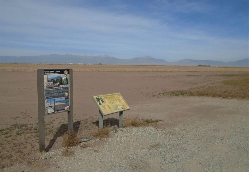
Facing east, one can see the deep notch in the mountains above the Great Sand Dunes. This is the likely route of Pike and his men as they crossed this majestic mountain range. As the valley was settled, agriculture became the leading industry and still is today. One can see the center pivot sprinklers irrigating crops such as potatoes, barley, hay and alfalfa.
[Bottom center map caption reads]
The route Pike followed to Medano Pass was not a frequently used pathway. However, it joined another from the Huerfano Valley which was doubtlessly the main track from the upper Arkansas to Taos via the San Luis Valley
[Bottom right Great Sand Dunes photo caption reads]
"Like the sea in a storm". 1807 (Pike)
For further reading:
"The Southwest Journals of Zebulon Pike - 1806-1807"
Hart, Hulbert, & Gardner
U of New Mexico Press 2006
Topics. This historical marker is listed in these topic lists: Environment • Exploration • Patriots & Patriotism. A significant historical date for this entry is January 29, 1807.
Location. 37° 39.765′ N, 105° 52.212′ W. Marker is in Mosca
, Colorado, in Alamosa County. Marker is on Lane 6N east of State Highway 17, on the left when traveling east. Marker is at a roadside pulloff. Touch for map. Marker is in this post office area: Mosca CO 81146, United States of America. Touch for directions.
Other nearby markers. At least 8 other markers are within 14 miles of this marker, measured as the crow flies. Welcome "Caminante" to... (a few steps from this marker); Los Caminos Antiguos (a few steps from this marker); Great Risk for Great Reward (a few steps from this marker); Who Owns This Land? (a few steps from this marker); "Old Mose" (approx. 13.1 miles away); 1988 NAIA Division 1 National Championship Runner-Up (approx. 13.1 miles away); Millstone, c. 1845 (approx. 13.3 miles away); Adams State College (approx. 13.4 miles away). Touch for a list and map of all markers in Mosca.
Related markers. Click here for a list of markers that are related to this marker. Other Pike Expedition Markers
Also see . . .
1. Zebulon Pike – Hard Luck Soldier & Explorer. Legends of America website entry (Submitted on August 17, 2021, by Larry Gertner of New York, New York.)
2. Zebulon Pike's Mysterious Western Expeditions. Thought Co. Website entry (Submitted on April 15, 2023, by Larry Gertner of New York, New York.)
Credits. This page was last revised on April 15, 2023. It was originally submitted on November 22, 2020, by William Fischer, Jr. of Scranton, Pennsylvania. This page has been viewed 210 times since then and 22 times this year. Photos: 1, 2. submitted on November 22, 2020, by William Fischer, Jr. of Scranton, Pennsylvania.

