Cape Elizabeth in Cumberland County, Maine — The American Northeast (New England)
National Guard
Photographed by Craig Doda, July 2, 2018
1. National Guard Marker
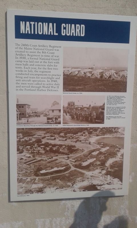
In 1941, Fort Williams became the regimental headquarters for the 240th Coast Artillery. Officers of the 8th and 240th regiments participated in exercises to test their response to fictitious enemy attacks by air, land, and sea.
Although never engaged in hostile actions, after the declaration of war on December 8, 1941, the regiments at Fort Williams were in a constant state of wartime readiness with training and alerts intensified.
Fort Williams was the last army post in Maine when it closed in 1962.
Topics. This historical marker is listed in these topic lists: Forts and Castles • War, World II. A significant historical date for this entry is December 8, 1941.
Location. 43° 37.347′ N, 70° 12.59′ W. Marker is in Cape Elizabeth, Maine, in Cumberland County. It is on Shore Road, on the right when traveling north. Touch for map. Marker is in this post office area: Cape Elizabeth ME 04107, United States of America. Touch for directions.

Regionally, this marker is on Southern Maine Coast. It is also in the American Northeast, in New England, and on the Eastern Seaboard. Globally, it is in the North Atlantic Region, North America, the Western Hemisphere, the Western World, and the Anglosphere.
Other nearby markers. At least 8 other markers are within walking distance of this marker:
this page online
Photographed by Craig Doda, July 2, 2018
2. National Guard Marker
Photographed by Craig Doda, July 2, 2018
3. National Guard Marker

Photographed by Craig Doda, July 2, 2018
4. National Guard Marker
Credits. This page was last revised on December 8, 2021. It was originally submitted on December 5, 2020, by Craig Doda of Napoleon, Ohio. This page has been viewed 257 times since then and 24 times this year. Photos: 1, 2, 3. submitted on December 5, 2020, by Craig Doda of Napoleon, Ohio. 4. submitted on November 28, 2021, by Craig Doda of Napoleon, Ohio. • Bill Pfingsten was the editor who published this page.
