Fort Peck in Valley County, Montana — The American West (Mountains)
Boomtowns on the Outskirts

Photographed by Barry Swackhamer, August 26, 2020
1. Boomtowns on the Outskirts Marker
Captions: (top left) Workers and their families needed more than just homes. Boomtowns like Wheeler, shown here, also provided schools, theaters, grocery stores, hardware stores, bars, and restaurants.; (bottom center) Ruby's Place in Wheeler was a popular spot for drinking and dancing.; (upper top right) Like many of the boomtowns that sprang up around Fort Peck Dam, New Deal was named in honor of President Roosevelt.; (lower top right) Boomtown homes were built to be temporary or portable. Most were 10 by 12 foot paper shacks like the one shown here in Park Grove, the only boomtown to survive, April 1935.
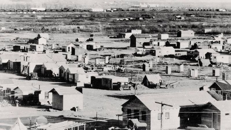
Barracks and dormitories were built in Fort Peck to house individual workers, but families had nowhere to live. More than 20 boomtowns sprang up just beyond the city limits of the carefully planned community of Fort Peck. Most were platted by the local farmer or rancher who owned the land.
By 1936, the dam employed nearly 11,000 workers. Many brought their families since the state gave hiring preferences to married men with dependents. Many other people came to open businesses.
After the dam was completed in 1940, the population of Fort Peck eventually fell back to a little more than 300 people. Businesses closed. Homes were torn down, taken home, or sold. Little remains of the boomtowns today.
Erected by U.S. Army Corps of Engineers.
Topics. This historical marker is listed in this topic list: Settlements & Settlers.
Location. 48° 0.603′ N, 106° 25.291′ W. Marker is in Fort Peck, Montana, in Valley County. It can be reached from Yellowstone Road near Winter Harbor,
this page online

Regionally, this marker is in Missouri River Country. It is also in the American Mountain West, in the Lewis & Clark Corridor, on the prairies, on the Great Plains, and specifically on the Northern Plains. Globally, it is in North America, the Western Hemisphere, the Western World, and the Anglosphere. Historically, it finds itself in what was once Rupert’s Land and also the Louisiana Purchase.
Other nearby markers. At least 8 other markers are within walking distance of this marker: Town Built for a Dam (here, next to this marker); Ponderosa Pine (a few steps from this marker); Diverting the Mighty Missouri (a few steps from this marker); Powerful Afterthoughts (a few steps from this marker); Dredging Up The Earth To Build A Dam (about 300 feet away, measured in a direct line); In Memory (approx. one mile away); Built with Muscle and Muck (approx. one mile away); Fort Peck Dam (approx. one mile away).

Photographed by Barry Swackhamer, August 26, 2020
2. Boomtowns on the Outskirts Marker
Photographed by PBSimages
3. Fort Peck boomtown
Credits. This page was last revised on July 26, 2026. It was originally submitted on December 8, 2020, by Barry Swackhamer of Brentwood, California. This page has been viewed 413 times since then and 46 times this year. Photos: 1, 2, 3. submitted on December 8, 2020, by Barry Swackhamer of Brentwood, California.
