Near Stanton in Mercer County, North Dakota — The American Midwest (Upper Plains)
Trading Post Plan
Fort Clark State Historic Site

Photographed By Barry Swackhamer, August 28, 2020
1. Trading Post Plan Marker
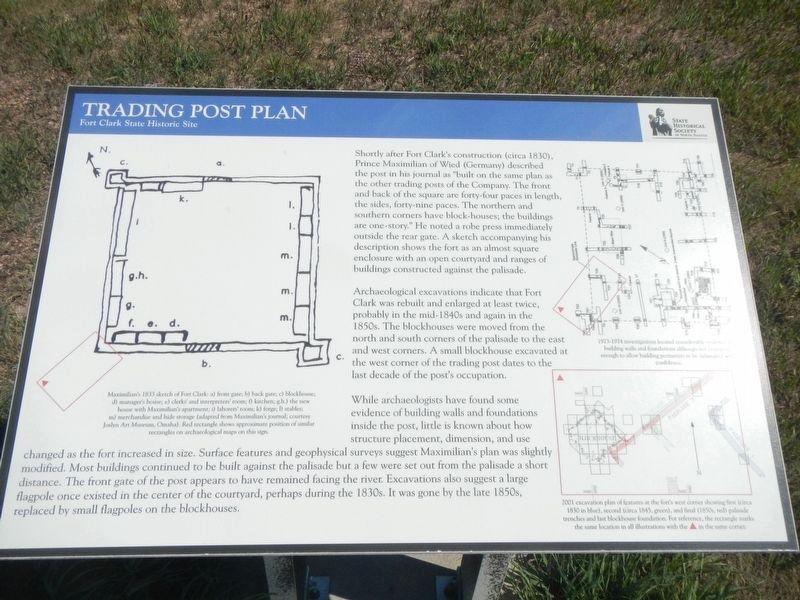
Captions: (upper left) Maximilian's 1833 sketch of Fort Clark: a9 front gate; b) back gate; c) blockhouse; d) manager's house; e) clerks; and interpreters; room; f) kitchen; gah) the new house with Maximilian's apartment; i) laborers; room; k) forge; l) stables; m) merchandise and hide storage,; (upper right) 1973-1974 investigations locate considerable evidence of building walls and foundations although not extensive enough to allow building perimeters to be delineated with confidence.; (bottom right) 2001 excavation plan of features at the fort 's west corner showing first (circa 1830 in blue), second (circa 1845, green), and final (1850s, red) palisade trenches and last blockhouse foundation. For reference, the rectangle marks the same location in all illustrations with the (red)▲ in the same corner.
Archeological excavations indicate that Fort Clark was built and enlarged at least twice, probably in the mid-1940s and again in the 1850s. The blockhouses were moved from north and south corners of the palisade to the east and west corners. A small blockhouse excavated at the west corner of the trading post dates to the last decade of the post's occupation.
While archaeologist have found some evidence of building walls and foundations inside the post, little is known about how structure placement, dimension, and use changed as the fort increased in size. Surface features and geophysical surveys suggest Maximilian's plan was slightly modified. Most buildings continued to be built against the palisade but a few were set out from the palisade as short distance. The front gate of the post appears to have remained facing the river. Excavations also suggest a large flagpole once existed in the center of the courtyard, perhaps during the 1830s. It was gone by the late 1850s, replaced by small flagpoles on the blockhouses.
Erected by State Historical Society of North Dakota.
Topics. This historical marker is listed in this topic list: Forts and Castles.
Location. 47° 15.032′ N, 101° 16.356′ W. Marker is near Stanton, North Dakota, in Mercer County. Marker can be reached from 37th Avenue Southwest near 12th Street Southwest (State Highway 200), on the right when traveling north. The marker is located at the Fort Clark State Historic Site. Touch for map. Marker is in this post office area: Stanton ND 58571, United States of America. Touch for directions.
Other nearby markers. At least 8 other markers are within walking distance of this marker. Two Bourgeois or Head Traders of the Fort (here, next to this marker); Geophysics and Archaeology (here, next to this marker); The Blockhouses (here, next to this marker); Pierre Garreau's Lodge (within shouting distance of this marker); Fort Clark (circa 1830-1860) (about 300 feet away, measured in a direct line); The People (about 300 feet away); Missouri Valley Environs
(about 500 feet away); Winter Villages and Lodges (about 500 feet away). Touch for a list and map of all markers in Stanton.
Credits. This page was last revised on December 13, 2020. It was originally submitted on December 13, 2020, by Barry Swackhamer of Brentwood, California. This page has been viewed 97 times since then and 9 times this year. Photos: 1, 2. submitted on December 13, 2020, by Barry Swackhamer of Brentwood, California.
