
Jones Homestead
| — | Grayson Highlands State Park | — |
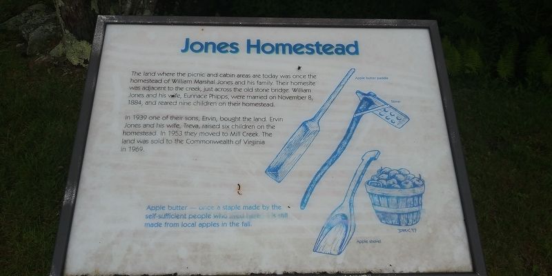
In 1939 one of their sons, Ervin, bought the land. Ervin Jones and his wife, Treva, raised six children on the homestead. In 1953 they moved to Mill Creek. The land was sold to the Commonwealth of Virginia in 1969.
Apple butter—once a staple made by the self-sufficient people who lived here is still made from local apples in the fall.
Erected by Grayson Highlands State Park.
Topics. This historical marker is listed in this topic list: Settlements & Settlers. A significant historical date for this entry is November 8, 1884.
Location. 36° 37.733′ N, 81° 28.756′ W. Marker is near Volney, Virginia, in Grayson County. It can be reached from Sugarlands Overlook Road 1.2 miles east of Grayson Highlands Lane (Route 362), on the left when traveling east. On the grounds of the Grayson Highlands State Park. Touch for map.
this page online

Regionally, this marker is in Southwest Virginia and in the Blue Ridge Highlands. It is also in the American South, specifically in the Upper South, in Appalachia, and specifically in Southern Appalachia. Globally, it is in North America, the Western Hemisphere, the Western World, and the Anglosphere. Historically, it finds itself in what was once the territory of the Mississippian Culture, one of the original Thirteen Colonies, one of the Confederate States of America, and the Antebellum South.
Other nearby markers. At least 8 other markers are within 4 miles of this marker, measured as the crow flies: Spencer Cabin (within shouting distance of this marker); Spring House (within shouting distance of this marker); Weavers Cabin (within shouting distance of this marker); Interpreter's Cabin (approx. 1.1 miles away); Rock House Ridge Trail (approx. 1.2 miles away); Grayson County (approx. 1.3 miles away); John Deere Mower Model 2 (approx. 1.3 miles away); North Carolina / Virginia (approx. 3.7 miles away in North
Credits. This page was last revised on December 23, 2020. It was originally submitted on December 19, 2020, by Craig Doda of Napoleon, Ohio. This page has been viewed 587 times since then and 35 times this year. Photos: 1, 2. submitted on December 19, 2020, by Craig Doda of Napoleon, Ohio. • Bernard Fisher was the editor who published this page.
