Ivanhoe in Wythe County, Virginia — The American South (Mid-Atlantic)
Ivanhoe
— New River Trail State Park —
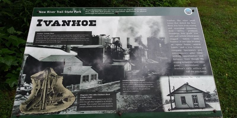
Ivanhoe, like other small towns that dotted the New River, was born from mining and quarrying industries. Area mines produced limestone, low grade iron ores and carbide which were shipped nation wide. Ivanhoe at one time boasted an opera house, several hotels and a iron furnace company. Speculators and entrepreneurs alike came seeking opportunities and fortunes. Even though the mining industries have since gone, descendants of Ivanhoe's early settlers still call the area home.
(captions)
Ivanhoe, Carbide Plant
Carbide was used for many years in mining lamps, head lights, and house hold uses. When carbide was mixed with water an acetylene gas was produced. This gas allowed small light sources to be used in various ways. Advancements in technology and electricity, eventually phased out the use of carbide as a fuel source for lights.
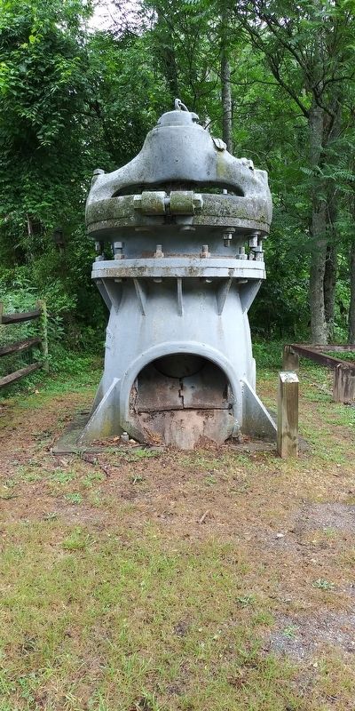
Diagram 1901 Allis-Chalmers Rock Crusher (Left)
Rock crushers were meant to be mobile, even though they weighed in at 40,000 pounds. This crusher was used locally to extract carbide from limestone deposits.
Ivanhoe Rail Station (Right)
Located along the Norfolk and Southern's North Carolina Branch near Austinville. The rail station served as a drop off and pick up of materials, dry goods and agriculture supplies.
Photos: Courteous of WCC, W.R. Chitwood M.D., Munsey Webb collection
Diagram: Courteous of Quarries and Beyond, Peggy Perazzo
Topics. This historical marker is listed in these topic lists: Industry & Commerce • Parks & Recreational Areas • Railroads & Streetcars.
Location. 36° 50.32′ N, 80° 57.221′ W. Marker is in Ivanhoe, Virginia, in Wythe County. Marker can be reached from Riverview Road (Virginia Route 639) 0.2 miles north of Ivanhoe Road (Virginia Route 94), on the right when traveling north. Located along the New River Trail near the Ivanhoe Access parking lot. Touch for map. Marker is in this post office area: Ivanhoe VA 24350, United States of America. Touch for directions.
Other nearby markers. At least 8 other markers are within 5 miles of this marker, measured as the crow flies. 1901 Allis Chalmers Rock Crusher (within shouting distance of this marker); Ivanhoe Furnace (about 400 feet away, measured in a direct line); a different marker also named Ivanhoe Furnace (about 600 feet away); Wythe County / Carroll County (approx. 0.8 miles away); To Mark The Site of The Lead Mines (approx. 1.9 miles away); Stephen Fuller Austin (approx. 2.2 miles away); Powering a Community (approx. 3.8 miles away); Fincastle County (approx. 4.3 miles away). Touch for a list and map of all markers in Ivanhoe.
Also see . . . New River Trail State Park. Virginia Department of Conservation and Recreation (Submitted on December 22, 2020.)
Credits. This page was last revised on May 18, 2022. It was originally submitted on December 20, 2020, by Craig Doda of Napoleon, Ohio. This page has been viewed 761 times since then and 114 times this year. Photos: 1, 2. submitted on December 20, 2020, by Craig Doda of Napoleon, Ohio. 3. submitted on May 18, 2022, by Bernard Fisher of Richmond, Virginia. 4, 5. submitted on December 20, 2020, by Craig Doda of Napoleon, Ohio. • Bernard Fisher was the editor who published this page.
