White River Greenway
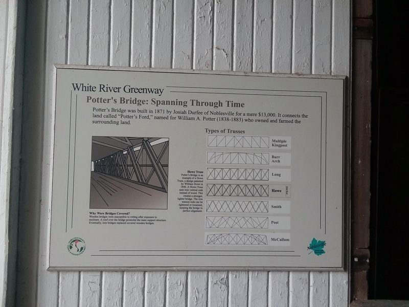
Potter's Bridge: Spanning Through Time
Potter's Bridge was built in 1871 by Josiah Durfee of Noblesville for a mere $13,000. It connects the land called "Potter's Ford,” named for William A. Potter (1838-1883) who owned and farmed the surrounding land.
Why Were Bridges Covered?
Wooden bridges were susceptible to rotting after exposure to
moisture. A roof over the bridge protected the main support structure.
Eventually, iron bridges replaced covered wooden bridges.
Howe Truss
Potter's Bridge is an
example of a Howe
Truss, a design patented
by William Howe in
1840. A Howe Truss
uses iron vertical rods
instead of wood. This
creates a stronger,
lighter bridge. The iron
tension rods can be
tightened or loosened,
keeping the bridge in
perfect alignment.
Erected by Hamilton County Parks & Recreation Dept.
Topics and series. This historical marker is listed in these topic lists: Agriculture • Architecture • Bridges & Viaducts. In addition, it is included in the Covered Bridges series list. A significant historical year for this entry is 1871.
Location. 40° 4.333′ N, 86° 0.017′ W. Marker is in Noblesville, Indiana, in Hamilton County. Marker is at the intersection of Allisonville Avenue and Covered Bridge Way, on the right
Other nearby markers. At least 8 other markers are within 2 miles of this marker, measured as the crow flies. Potter's Covered Bridge (within shouting distance of this marker); The Central Canal (approx. 0.8 miles away); Crownland Cemetery Veterans Memorial (approx. 1.3 miles away); Bryan Clauson (approx. 1.4 miles away); Cole-Evans House (approx. 1.6 miles away); Harrell House (approx. 1.7 miles away); Conner Street Historic District (approx. 1.8 miles away); Union Traction Station (approx. 1.9 miles away). Touch for a list and map of all markers in Noblesville.
Also see . . . Potter's Covered Bridge. (Submitted on December 21, 2020, by Craig Doda of Napoleon, Ohio.)
Credits. This page was last revised on December 21, 2020. It was originally submitted on December 21, 2020, by Craig Doda of Napoleon, Ohio. This page has been viewed 119 times since then and 13 times this year. Photos: 1, 2, 3. submitted on December 21, 2020, by Craig Doda of Napoleon, Ohio. • Devry Becker Jones was the editor who published this page.


