Final Occupation of Double Ditch
— Double Ditch State Historic Site —
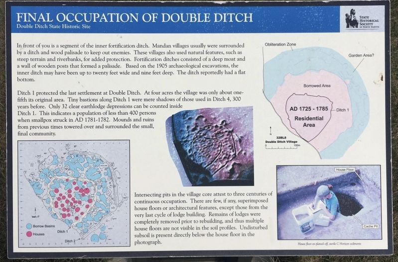
Ditch 1 protected the last settlement at Double Ditch. At four acres the village was only about one- fifth its original area. Tiny bastions along Ditch 1 were mere shadows of those used in Ditch 4, 300 years before. Only 32 clear earthlodge depressions can be counted inside Ditch 1. This indicates a population of less than 400 persons when smallpox struck in AD 1781-1782. Mounds and ruins from previous times towered over and surrounded the small, final community.
Intersecting pits in the village core attest to three centuries of continuous occupation. There are few, if any, superimposed house floors or architectural features, except those from the very last cycle of lodge building. Remains of lodges were completely removed prior to rebuilding, and thus multiple house floors are not visible in the soil profiles.
Undisturbed subsoil is present directly below the house floor in the photograph. Caption:
House floor on planed-off, sterile C Horizon sediments
Erected by State Historical Society of North Dakota.
Topics. This historical marker is listed in these topic lists: Native Americans • Settlements & Settlers. A significant historical year for this entry is 1781.
Location. 46° 56.096′ N, 100° 53.933′ W. Marker is near Bismarck, North Dakota, in Burleigh County. Marker can be reached from North Dakota Route 1804. Touch for map. Marker is in this post office area: Bismarck ND 58503, United States of America. Touch for directions.
Other nearby markers. At least 8 other markers are within walking distance of this marker. Archaeological Excavations in 1905 (within shouting distance of this marker); Ditch 2 (within shouting distance of this marker); Missouri River Resources (about 300 feet away, measured in a direct line); Geophysical Prospecting in Archaeology (about 300 feet away); Homes (about 400 feet away); Ditch 3 (about 400 feet away); Double Ditch State Historic Site (about 500 feet away); Midden Mounds (Trash Heaps) (about 500 feet away). Touch for a list and map of all markers in Bismarck.
Also see . . . State Historical Society of North Dakota on the Double Ditch State Historic Site. (Submitted on January 11, 2021, by Connor Olson of Kewaskum, Wisconsin.)
Credits. This page was last revised on January 13, 2021. It was originally submitted on January 11, 2021, by Connor Olson of Kewaskum, Wisconsin. This page has been viewed 103 times since then and 4 times this year. Photos: 1, 2. submitted on January 11, 2021, by Connor Olson of Kewaskum, Wisconsin. • Mark Hilton was the editor who published this page.

