Shanks Mill
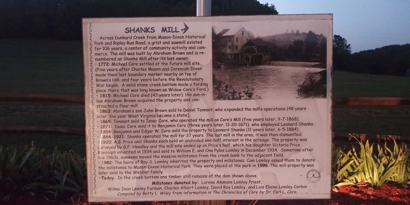
• 1772: Michael Core settled at the future mill site. (Five years after Charles Mason and Jeremiah Dixon made their last boundary marker nearby on top of Brown's Hill, and four years before the Revolutionary War began, A solid stone creek bottom made a fording place there that was long known as Widow Core's Ford.)
•1815: Michael Core died (43 years later). His son-in-law Abraham Brown acquired the property and constructed a flour mill.
• 1863: Abraham's son John Brown sold to Daniel Tennant, who expanded the mill's operations (48 years later, the year West Virginia became a state).
• 1868: Tennant sold to Isaac Core, who operated the mill as Core's Mill (five years later, 9-7-1868).
• 1871: Isaac Core sold it to Benjamin Core (three years later, 11-20-1871), who employed Leonard Shanks.
• 1884: Benjamin and Edgar W. Core sold the property to Leonard
this page online
• 1884-1921: Shanks operated the mill for 37 years. The last mill in the area, it was then dismantled.
• 1920: A.B. Price and Shanks each held an undivided one-half interest in the acreage. The property was s urveyed by G.F. Headley and the mill site ended up on Price's half, which his daughter Victoria Price Randolph inherited in 1934 and sold to William E. and Ona Pyles Lemley in December 1934. Sometime after the 1960s, someone moved the massive millstones from the creek bank to the adjacent field.
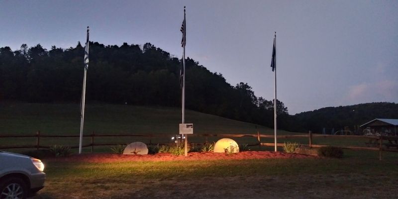
• 1982: The heirs of Roy S. Lemley inherited the property and millstones. Cam Lemley asked them to donate the millstones to Mason-Dixon Historical Park. They were placed at the park in 1996. The mill property was later sold to the Webber family.
• Today: In the creek bottom one timber still remains of the dam shown above.
Millstones donated by: Lorene Ammons Lemley Priest,
Wilma Jean Lemley Furman, Charles Albert Lemley, David Roy Lemley, and Lois Elaine Lemley Corbin
Compiled by Betty L. Wiley from information in The Chronicles of Core by Dr. Earl L. Core.
Topics. This historical
Location. 39° 42.832′ N, 80° 6.825′ W. Marker is in Core, West Virginia, in Monongalia County. It is on Buckeye Road (County Route 39), on the left when traveling east. On the grounds of the Mason-Dixon Historical Park. Touch for map. Marker is in this post office area: Maidsville WV 26541, United States of America. Touch for directions.

Regionally, this marker is in North Central West Virginia. It is also in the American South, specifically in the Upper South, in Appalachia, and specifically in Northern Appalachia. Globally, it is in North America, the Western Hemisphere, the Western World, and the Anglosphere. Historically, it finds itself in what was once the territory of the Mississippian Culture.
Other nearby markers. At least 8 other markers are within 3 miles of this marker, measured as the crow flies: History of the Mason-Dixon Survey and Historical Park (within shouting distance of this marker); Walking in the Footsteps of History (within shouting distance of this marker); Aerial View - Dunkard Creek, Mason-Dixon Historical Park, and Monongahela Village Site
Other markers no longer nearby. Catawba War Path (was within shouting distance of this marker but has been confirmed missing); Statler's Fort (was approx. 1.3 miles away but has been permanently removed).
Credits. This page was last revised on May 23, 2022. It was originally submitted on January 18, 2021, by Craig Doda of Napoleon, Ohio. This page has been viewed 798 times since then and 52 times this year. Photos: 1, 2, 3. submitted on January 18, 2021, by Craig Doda of Napoleon, Ohio. 4, 5. submitted on April 27, 2022, by Bradley Owen of Morgantown, West Virginia. • Bill Pfingsten was the editor who published this page.
