Buckeye Furnace in Jackson County, Ohio — The American Midwest (Great Lakes)
Buckeye Furnace Covered Bridge
Photographed by Craig Doda, October 23, 2020
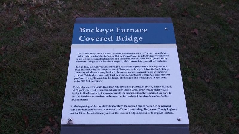
1. Buckeye Furnace Covered Bridge Marker
The covered bridge era in America was from the nineteenth century. The last covered bridge of this period was built by the State of Ohio in Vinton County in 1919, Bridges were enclosed to protect the wooden structural parts and decks from rain and snow and to prevent decay. Uncovered bridges would last about ten years, while covered bridges could last centuries.
Built in 1872, the Buckeye Furnace Bridge is historically important because it represents a truss built following the designs of one of Ohio's premier bridge builders, the Smith Bridge Company, which was among the first in the nation to make covered bridges an industrial product. This bridge was actually built by Dency, McCurdy, and Company, a local firm that purchased the rights to use Smith's design. The bridge is 68.5 feet long and 16 feet wide, with a 58.5 feet clear span.
This bridge used the Smith Truss plan, which was first patented in 1867 by Robert W. Smith of Tipp City (originally Tippecanoe), and later Toledo, Ohio. Smith would prefabricate a bridge in Toledo and ship the components to the erection site, or he would sell the parts to another builder-as
this page online
At the beginning of the twentieth-first century, the covered bridge needed to be replaced with a modern span because of increased traffic and overloading. The Jackson County Engineer and the Ohio Historical Society moved the covered bridge adjacent to its original location.
Topics and series. This historical marker is listed in these topic lists: Bridges & Viaducts • Industry & Commerce. In addition, it is included in the Appalachian Iron Furnaces, and the Covered Bridges series lists. A significant historical year for this entry is 1919.
Location. 39° 3.28′ N, 82° 27.509′ W. Marker is in Buckeye Furnace, Ohio, in Jackson County. It is on Buckeye Road (County Road 165) 0.1 miles east of Buckeye Park Road (County Road 167), on the right when traveling east. Touch for map. Marker is at or near this postal address: 316 Buckeye Rd, Wellston OH 45692, United States of America. Touch for directions.

Regionally, this marker is in Southern Ohio Hill Country. It is also in the American Midwest, in Appalachia, and specifically in Northern Appalachia.
Photographed by Craig Doda, October 23, 2020
2. Buckeye Furnace Covered Bridge Marker
Other nearby markers. At least 8 other markers are within walking distance of this marker: Buckeye Furnace (1851 - 1894) (a few steps from this marker); a different marker also named Scales (within shouting distance of this marker); Hanging Rock Region (within shouting distance of this marker); Civil War (within shouting distance of this marker); Furnace Communities (within shouting distance of this marker); Casting (about 700 feet away, measured in a direct line); Bridge Loft/Charging House (about 700 feet away); a different marker also named Stock Shed (about 700 feet away). Touch for a list and map of all markers in Buckeye Furnace.
Other markers no longer nearby. Buckeye Furnace (was a few steps from this marker but has been confirmed missing); Scales (was within shouting distance of this marker but has been replaced with another marker now near it); a different

Photographed by Craig Doda, October 23, 2020
3. Buckeye Furnace Covered Bridge
Also see . . . Buckeye Furnace Covered Bridge. (Submitted on February 10, 2021, by Craig Doda of Napoleon, Ohio.)

Photographed by Craig Doda, October 23, 2020
4. Buckeye Furnace Covered Bridge

Photographed by Craig Doda, October 23, 2020
5. Buckeye Furnace Covered Bridge

Photographed by Craig Doda, October 23, 2020
6. Buckeye Furnace Covered Bridge
Credits. This page was last revised on August 19, 2026. It was originally submitted on February 10, 2021, by Craig Doda of Napoleon, Ohio. This page has been viewed 474 times since then and 64 times this year. Last updated on August 18, 2026, by Craig Doda of Napoleon, Ohio. Photos: 1, 2, 3, 4, 5, 6. submitted on February 10, 2021, by Craig Doda of Napoleon, Ohio. • Devry Becker Jones was the editor who published this page.
