Near Brandy Station in Culpeper County, Virginia — The American South (Mid-Atlantic)
The Battle of Brandy Station
The Stone Wall on the Cunningham Farm
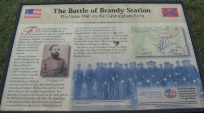
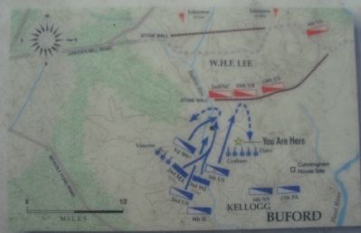
Rooney Lee was a skilled fighter and used the terrain well. First he blocked Buford's progress by the stone wall five hundred yards in front of you. From his command post on the knoll behind you, Buford saw that a portion of Lee's dismounted regiments were placed between Ruffans Run and the Hazel River (to your left and right respectively). Two unlimbered cannon were located on the other side of the hill behind the stone wall. Since the disposition of the enemy and the channels of the two water courses left him no alternative, Buford launched several mounted and dismounted charges against the wall. Blistering fire from Lee's brigade held the Federals back for several hours.
Some infantry with Buford were ordered to sneak through a wheat field along Ruffans Run to pounce on the Confederate flank. The Confederates ran for their horses and began to fall back.
But Rooney Lee had another reason for pulling back. Brig. Gen. David M. Gregg's Union cavalry had finally entered the battle from the south, at Brandy Station.
Help Preserve Battlefields • call CWPT at 1-888-606-1400 • www.civilwar.org • The Hallowell Foundation generously contributed toward the interpretation of this site in memory of Carrington Williams.
This material is based upon work assisted by a grant from the Department of the Interior, National Park Service. Any opinion, findings and conclusions or recommendations expressed in this material are those of the author(s) and do not necessarily reflect the views of the Department of the Interior.
Erected by Civil War Preservation Trust.
Topics. This historical marker is listed in this topic list: War, US Civil.
Location. 38° 32.592′ N, 77° 51.509′ W. Marker is near Brandy Station, Virginia, in Culpeper County. Marker can be reached from Beverly Ford Road (Route 676), on the right when traveling north. Located at the fourth trail stop wayside for the Buford's Knoll Walking Trail of the the Battle of Brandy Station. Touch for map. Marker is in this post office area: Brandy Station VA 22714, United States of America. Touch for directions.
Other nearby markers. At least 8 other markers are within 2 miles of this marker, measured as the crow flies. A different marker also named The Battle of Brandy Station (within shouting distance of this marker); a different marker also named The Battle of Brandy Station (approx. 0.6 miles away); a different marker
More about this marker. On the left side of the marker is a portrait of Gen. "Rooney" Lee. The lower center displays a photo of "Troopers of the 5th U.S. Cavalry which helped to drive the Confederates from the stone wall in front of you." On the upper right is a map illustrating the movements described in the text for this phase of the battle.
Regarding The Battle of Brandy Station. This is one of several markers interpreting the Battle of Brandy Station and the winter encampments of 1863-64 in Culpeper County. See the Battle
of Brandy Station Virtual Tour by Markers linked below for additional related markers.
Also see . . .
1. Battle of Brandy Station. National Park Service summary of the battle includes a driving tour. (Submitted on December 30, 2007, by Craig Swain of Leesburg, Virginia.)
2. Brandy Station Foundation. Through the efforts of the Brandy Station Foundation, Civil War Preservation Trust, and other organizations, over 960 acres of this battlefield have been preserved. (Submitted on December 30, 2007, by Craig Swain of Leesburg, Virginia.)
3. Brandy Station. Civil War Preservation Trust classroom article on the battle. (Submitted on December 30, 2007, by Craig Swain of Leesburg, Virginia.)
4. Account of the 2nd Massachusetts in the Battle. When asked if the infantry could indeed drive back the Confederate cavalry, Captain Daniel Oakey would remark, "It would hardly do to back out in the presence of so distinguished a cavalry audience, if there was a chance of success." Certainly a bit of bravado in the face of a combat situation, but backed up by the actions of the unit along with the 3rd Wisconsin. (Submitted on December 30, 2007, by Craig Swain of Leesburg, Virginia.)
5. Battle of Brandy Station Virtual Tour by Markers. A set markers that document the Battle of Brandy Station, June 9, 1863, and the Winter Encampment
of 1863-64. Note the order of appearance is geographic and not chronologically aligned to the battle. (Submitted on January 1, 2008, by Craig Swain of Leesburg, Virginia.)
Additional commentary.
1. Cavalry vs. Infantry on the Civil War Battlefield
The action at this point of the battle highlights some of the capabilities and limitations of infantry and cavalry forces on the Civil War battlefield. In this case, Confederate cavalry, armed with short ranged carbines, posted behind the defensible stone wall, were able to hold against Federal cavalry advances. However this Confederate line, because they were on foot, was weakened by the necessity of detailing every fourth man as a horse holder. Thus when confronted with an infantry line, which could pack more rifles within the same amount of space as the dismounted cavalry line, the defenders were at a distinct disadvantage.
— Submitted December 30, 2007, by Craig Swain of Leesburg, Virginia.
Photographed By Craig Swain, December 22, 2007
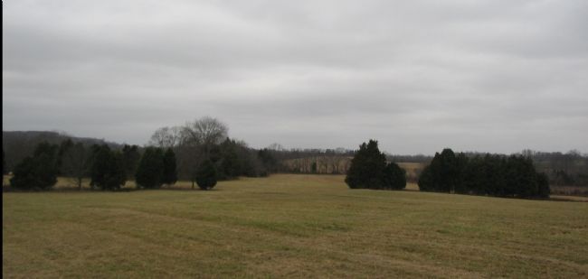
5. "Rooney" Lee's Line
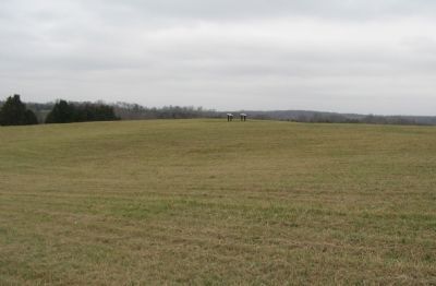
Looking west from the marker, the fence line running from the left (beyond the trees in the open field) is approximately the location of the stone wall. Buford sent the 5th U.S. Cavalry down the slope here to attack the Confederate positions.
Photographed By Craig Swain, December 22, 2007
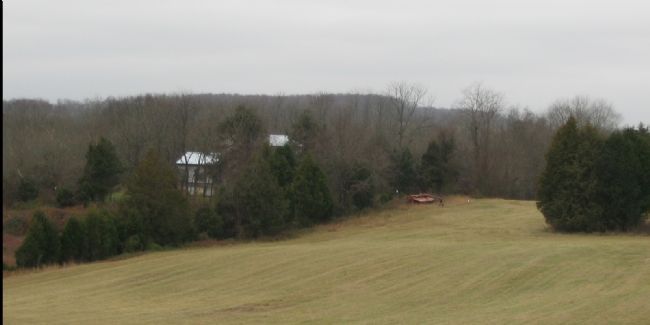
7. Buford's Attacks
Looking southeast, just to the left of the previous photo (Number 4 above), in this frame can be seen the approaches used by the 2nd U.S. Cavalry to attack the Confederate line, which was just beyond the house in the left of frame. Crossing just behind the house was the 6th Pennsylvania Cavalry. Later companies from the 2nd Massachusetts and the 3rd Wisconsin Infantry would advance through the wheat field here and finally drive the Confederate right flank back from Ruffans Run (which is to the left of the house in this frame).
Credits. This page was last revised on February 17, 2021. It was originally submitted on December 30, 2007, by Craig Swain of Leesburg, Virginia. This page has been viewed 2,482 times since then and 28 times this year. Last updated on February 16, 2021, by Bradley Owen of Morgantown, West Virginia. Photos: 1. submitted on December 30, 2007, by Craig Swain of Leesburg, Virginia. 2. submitted on March 13, 2009, by Craig Swain of Leesburg, Virginia. 3, 4, 5. submitted on December 30, 2007, by Craig Swain of Leesburg, Virginia. 6. submitted on February 16, 2021, by Bradley Owen of Morgantown, West Virginia. 7. submitted on December 30, 2007, by Craig Swain of Leesburg, Virginia. • Bill Pfingsten was the editor who published this page.
