Santa Barbara in Santa Barbara County, California — The American West (Pacific Coastal)
Santa Barbara's First People
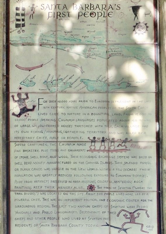
For over 10,000 years prior to European settlement in the late 18th century, Native American peoples of the South Coast lived close to nature in a bountiful land. From 15,000 to 20,000 people speaking Chumash languages populated over 150 towns of large, willow-framed houses thatched with tule. Each village had its own fishing/hunting/gathering territory and was ruled by a hereditary chief, male or female.
Superb craftsmen, the Chumash made fine basketry, plus tools and ornaments of stone, shell, bone, and wood. Their economic exchange system was based on shell bead money manufactured on the Channel Islands. Their splendid Tomol or plank canoe was unique in the New World. Within a few decades their population was greatly reduced following exposure to European diseases. Aside from artifacts preserved in area museums, colorful, mysterious rock paintings keep their memory alive.
The town of Syuxtun ("Where the trail divides") was located on this site. About 500 people lived here, led by a powerful chief. This was an important political and economic center for the surrounding region. The last known two chiefs of Syuxtun were Pedro Yanonali and Pablo Lihuisanaiset. Descendants of these chiefs and other people who lived at Syuxtun are residents of Santa Barbara County today.
Topics. This historical marker is listed in this topic list: Native Americans.
Location. 34° 24.678′ N, 119° 41.425′ W. Marker is in Santa Barbara, California, in Santa Barbara County. Marker is at the intersection of Cabrillo Boulevard and Chapala Street, on the right when traveling west on Cabrillo Boulevard. Touch for map. Marker is at or near this postal address: 28 W Cabrillo Blvd, Santa Barbara CA 93101, United States of America. Touch for directions.
Other nearby markers. At least 8 other markers are within walking distance of this marker. Santa Barbara Veterans' Memorial Building (within shouting distance of this marker); Burton’s Mound (within shouting distance of this marker); Burton Mound (about 500 feet away, measured in a direct line); Fly To-Day (about 700 feet away); Sambo's Birthplace (about 700 feet away); Santa Barbara Railroad Station (approx. 0.2 miles away); Private Railcar Spurs (approx. ¼ mile away); Moreton Bay Fig Tree (approx. ¼ mile away). Touch for a list and map of all markers in Santa Barbara.
Credits. This page was last revised on February 27, 2021. It was originally submitted on February 24, 2021, by Craig Baker of Sylmar, California. This page has been viewed 264 times since then and 44 times this year. Photos: 1, 2. submitted on February 24, 2021, by Craig Baker of Sylmar, California. • J. Makali Bruton was the editor who published this page.

