St. Charles in St. Charles County, Missouri — The American Midwest (Upper Plains)
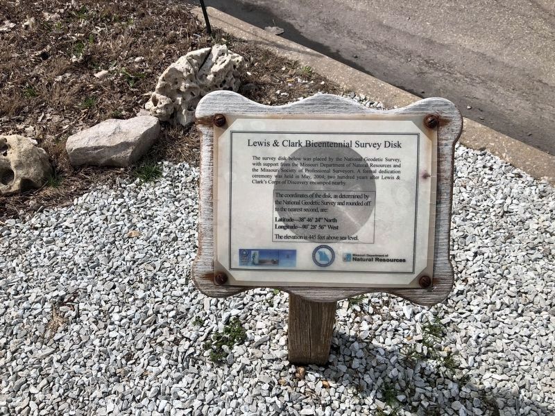
Lewis & Clark Bicentennial Survey Disk
Photographed by Devry Becker Jones (CC0), March 22, 2021
1. Lewis & Clark Bicentennial Survey Disk Marker
The survey disk below was placed by the National Geodetic Survey, with support from the Missouri Department of Natural resources and the Missouri Society of Professional Surveyors. A formal dedication ceremony was held in May, 2004; two hundred years after Lewis & Clark's Corps of Discovery encamped nearby.
The coordinates of the disk, as determined by the National Geodetic Survey and rounded off to the nearest second, are:
Latitude—38° 46' 24" North
Longitude—90° 28' 56" West
The elevation is 445 feet above sea level.
Erected by The National Geodetic Survey; Missouri Society of Professional Surveyors; Missouri Department of Natural Resources.
Topics. This historical marker is listed in this topic list: Exploration. A significant historical month for this entry is May 1804.
Location. Marker has been reported missing. It was located near 38° 46.402′ N, 90° 28.925′ W. Marker was in St. Charles, Missouri, in St. Charles County. It was at the intersection of South Riverside Drive and Boone's Lick Road, on the right when traveling south on South Riverside Drive. Touch for map. Marker was at or near this postal
this page online

Regionally, this marker was in the Missouri River Corridor and in Greater St. Louis. It was also in the American Midwest, in the Lewis & Clark Corridor, in the Corn Belt, and in the Great River Road Region. Globally, it was in North America, the Western Hemisphere, the Western World, and the Anglosphere. Historically, it found itself in what was once the territory of the Mississippian Culture, the Louisiana Purchase, and the Antebellum South.
Other nearby markers. At least 8 other markers are within walking distance of this location: The Lewis and Clark Expedition Across Missouri (within shouting distance of this marker); May 21, 1804 (within shouting distance of this marker); Bishop's Landing (within shouting distance of this marker); The Experiment (within shouting distance of this marker); Tracking the Boats (within shouting distance of this marker); Peter Geery (about 300 feet away, measured in a direct line); Veterans Memorial (about 300 feet away); 921 South Riverside Drive (approx. 0.2 miles away). Touch for a list and map

Photographed by Devry Becker Jones (CC0), March 22, 2021
2. Lewis & Clark Bicentennial Survey Disk with the marker
Other markers no longer nearby. Marsh Mallows (was within shouting distance of this marker but has been confirmed missing); Sunflower (was within shouting distance of this marker but has been confirmed missing); Corn, Pole Beans, Squash / Habanero & Jalapeno Peppers / Tomato (was within shouting distance of this marker but has been confirmed missing); Onions (was within shouting distance of this marker but has been confirmed missing); Potato (was within shouting distance of this marker but has been confirmed missing); 25th Anniversary (was about 600 feet away but has been permanently removed).

Photographed by Garrett Koch, September 7, 2025
3. Lewis & Clark Bicentennial Survey Disk Marker IS MISSING!
2025-9-7. upon visiting the Lewis & Clark Boathouse & Museum this marker was missing as shown. Just as all of the wooden signboards on short posts in the ground around that area, the posts and signboards remained but the information on the signboards were completely gone. It's possible that flood waters had washed that information away but it has been quite a while since the Missouri River had flooded that high to cause this damage.
Credits. This page was last revised on September 12, 2025. It was originally submitted on March 23, 2021, by Devry Becker Jones of Washington, District of Columbia. This page has been viewed 328 times since then and 27 times this year. Photos: 1, 2. submitted on March 27, 2021, by Devry Becker Jones of Washington, District of Columbia. 3. submitted on September 8, 2025, by Garrett Koch of Saint Louis, Missouri.
