
Washington in Franklin County, Missouri — The American Midwest (Upper Plains)
1935 St. Francis Borgia School Building
Photographed by Devry Becker Jones (CC0), March 19, 2021
1. 1935 St. Francis Borgia School Building Marker
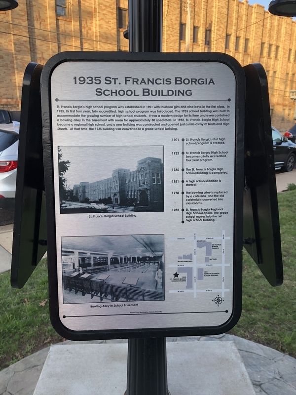
St. Francis Borgia's high school program was established in 1901 with fourteen girls and nine boys in the first class. In 1933, its first four year, fully accredited, high school program was introduced. The 1935 school building was built to accommodate the growing number of high school students. It was a modern design for its time and even contained a bowling alley in the basement with room for approximately 80 spectators. In 1982, St. Francis High School became a regional high school, and a new building was constructed and opened just a mile away at Ninth and High Streets. At that time, the 1935 building was converted to a grade school building.
1901 • St. Francis Borgia's first high school program is created.
1933 • St. Francis Borgia High School becomes a fully accredited, four year program.
1935 • The St. Francis Borgia High School Building is completed.
1951 • A high school addition is started.
1978 • The bowling alley is replaced by a cafeteria, and the old cafeteria is converted into classrooms.
1982 • St. Francis Borgia Regional High School opens. The grade school moves into the old high school building.
Erected by Washington
this page online
Topics. This historical marker is listed in these topic lists: Education • Religion & Religious Structures • Sports. A significant historical year for this entry is 1901.
Location. 38° 33.64′ N, 91° 0.885′ W. Marker is in Washington, Missouri, in Franklin County. It is at the intersection of Cedar Street and West 2nd Street, on the right when traveling south on Cedar Street. Touch for map. Marker is at or near this postal address: 115 Cedar St, Washington MO 63090, United States of America. Touch for directions.

Regionally, this marker is in the Missouri River Corridor and in Greater St. Louis. It is also in the American Midwest, in the Lewis & Clark Corridor, in the Corn Belt, and on the Santa Fe Trail Corridor. Globally, it is in North America, the Western Hemisphere, the Western World, and the Anglosphere. Historically, it finds itself in what was once the territory of the Mississippian Culture, the Louisiana Purchase, and the Antebellum South.
Other nearby markers. At least 8 other markers are within walking distance of this marker: 1891 St. Francis Borgia School Building

Photographed by Duane and Tracy Marsteller, July 20, 2024
2. 1935 St. Francis Borgia School Building Marker
Featured marker is on the right.
Credits. This page was last revised on August 19, 2024. It was originally submitted on March 24, 2021, by Devry Becker Jones of Washington, District of Columbia. This page has been viewed 502 times since then and 53 times this year. Photos: 1. submitted on March 24, 2021, by Devry Becker Jones of Washington, District of Columbia. 2. submitted on August 13, 2024, by Duane and Tracy Marsteller of Murfreesboro, Tennessee.
