Robertson House Fight
Last Cavalry Clash at Appomattox
— Lee's Retreat —
After Union Gen. Ulysses S. Grant's forces broke through Confederate Gen. Robert E. Lee's lines at Petersburg on April 2, 1865, Lee ordered the evacuation of Petersburg and Richmond. The Army of Northern Virginia retreated west on several roads, with Grant in pursuit. Lee planned to turn south and join Gen. Joseph E. Johnston in North Carolina, but Grant, closely pursuing the Confederate army, kept part of the Federal force south of Lee to thwart his plans. On April 9, surrounded at Appomattox Court House, Lee surrendered.
(main text)
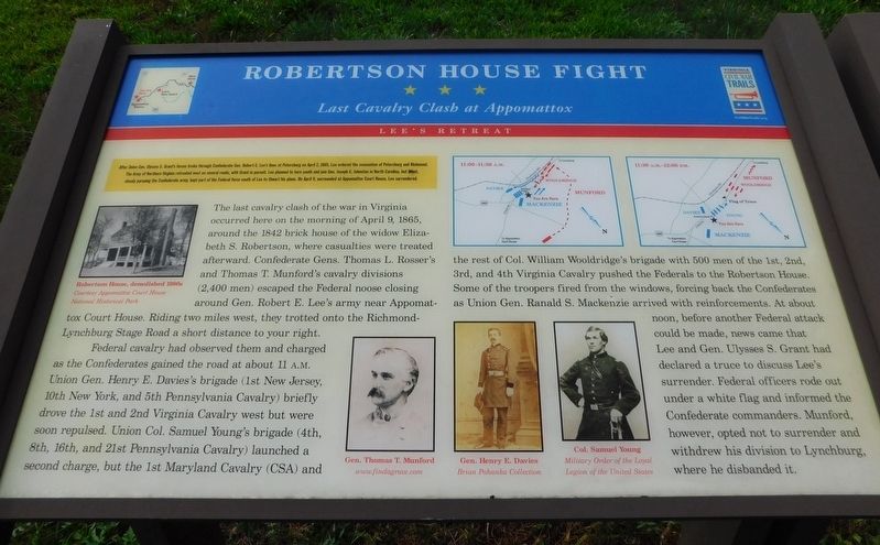
The last cavalry clash of the war in Virginia occurred here on the morning of April 9, 1865, around the 1842 brick house of the widow Elizabeth S. Robertson, where casualties were treated afterward. Confederate Gens. Thomas L. Rosser's and Thomas T. Munford's cavalry divisions (2,400 men) escaped the Federal noose closing around Gen. Robert E. Lee's army near Appomattox Court House. Riding two miles west, they trotted onto the Richmond-Lynchburg Stage Road a short distance to your right.
Federal cavalry had observed them and charged as the Confederates gained the road at about 11 A.M. Union Gen. Henry E. Davies's brigade (1st New Jersey, 10th New York, and 5th Pennsylvania Cavalry) briefly drove the 1st and 2nd Virginia Cavalry west but were soon repulsed. Union
Col. Samuel Young's brigade (4th, 8th, 16th, and 21st Pennsylvania Cavalry) launched a second charge, but the 1st Maryland Cavalry (CSA) and the rest of Col. William Wooldridge's brigade with 500 men of the 1st, 2nd, 3rd, and 4th Virginia Cavalry pushed the Federals to the Robertson House. Some of the troopers fired from the windows, forcing back the Confederates as Union Gen. Ranald S. Mackenzie arrived with reinforcements. At about noon, before another Federal attack could be made, news came that Lee and Gen. Ulysses S. Grant had declared a truce to discuss Lee's surrender. Federal officers rode out under a white flag and informed the Confederate commanders. Munford, however, opted not to surrender and withdrew his division to Lynchburg, where he disbanded it.
(captions)
Robertson House, demolished 1990s Courtesy Appomattox Court House National Historical Park
Gen. Thomas T. Munford www.findagrave.com
Gen. Henry E. Davies Brian Pohanka Collection
Col. Samuel Young Military Order of the Loyal Legion of the United States
Erected by Virginia Civil War Trails.
Topics and series. This historical marker is listed in this topic list: War, US Civil. In addition, it is included in the Virginia Civil War Trails series list. A significant historical date for this entry is April 9, 1865.
Location.
Other nearby markers. At least 8 other markers are within walking distance of this marker. A different marker also named Robertson House Fight (here, next to this marker); The Last Positions (approx. ¼ mile away); Eldon (approx. ¼ mile away); Carver-Price School (approx. 0.8 miles away); Winonah Camp / Mozella Price Home (approx. 0.8 miles away); Custer's Third Brigade (approx. 0.8 miles away); Walker's Last Stand (approx. 0.9 miles away); Confederate Artillery Position (approx. 0.9 miles away). Touch for a list and map of all markers in Appomattox.
Credits. This page was last revised on March 24, 2021. It was originally submitted on March 24, 2021, by Bradley Owen of Morgantown, West Virginia. This page has been viewed 340 times since then and 26 times this year. Photos: 1, 2. submitted on March 24, 2021, by Bradley Owen of Morgantown, West Virginia. • Bernard Fisher was the editor who published this page.
Editor’s want-list for this marker. Wide shot of marker and its surroundings. • Can you help?

