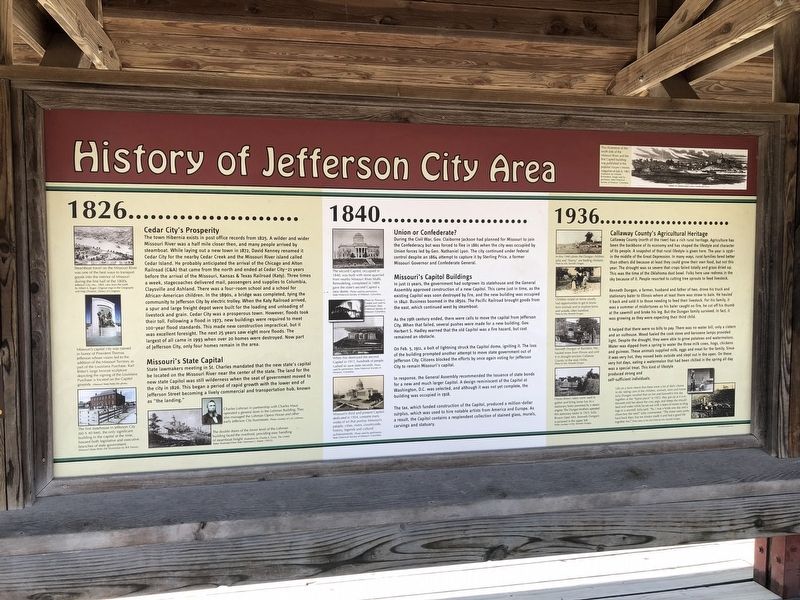
History of Jefferson City Area
1826
Cedar City's Prosperity
The town Hibernia exists in post office records from 1825. A wilder and wider Missouri River was a half mile closer then, and many people arrived by steamboat. While laying out a new town in 1872, David Kenney renamed it Cedar City for the nearby Cedar Creek and the Missouri island called Cedar Island. He probably anticipated the arrival of the Chicago and Alton Railroad (C&A) that came from the north and ended at Cedar City—21 years before the arrival of the Missouri, Kansas & Texas Railroad (Katy). Three times a week, stagecoaches delivered mail, passengers and supplies to Columbia, Claysville and Ashland. There was a four-room school and a school for African-American children. In the 1890s, a bridge was completed, tying the community to Jefferson City by electric trolley. When the Katy Railroad arrived, a spur and large freight depot were built for the loading and unloading of livestock and grain. Cedar City was a prosperous town. However, floods took their toll. Following a flood in 1973, new buildings were required to meet 100-year flood standards. This made new construction impractical, but it was excellent foresight. The next 25 years saw eight more floods. The largest of all came in 1993 when over 20 homes were destroyed. Now part of Jefferson City, only four homes remain in the area.
Missouri's State Capital
State lawmakers meeting in St. Charles mandated that the new state's capital be located on the Missouri River near the center of the state. The land for the new state Capitol was still wilderness when the seat of government moved to the city in 1826. This began a period of rapid growth with the lower end of Jefferson Street becoming a lively commercial and transportation hub, known as "the landing."
1840
Union or Confederate?
During the Civil War, Gov. Claiborne Jackson had planned for Missouri to join the Confederacy but was forced to flee in 1861 when the city was occupied by Union forces led by Gen. Nathaniel Lyon. The city continued under federal control despite an 1864 attempt to capture it by Sterling Price, a former Missouri Governor and Confederate General.
Missouri's Capitol Buildings
In just 11 years, the government had outgrown its statehouse and the General Assembly approved construction of a new Capitol. This came just in time, as the existing Capitol was soon destroyed by fire, and the new building was occupied in 1840. Business doomed in the 1850s. The Pacific Railroad brought goods from the east, which continued west by steamboat.
As the 19th century ended, there were calls to move the capital from Jefferson City. When that failed, several pushes were made
On Feb. 5, 1911, a bolt of lightning struck the Capitol dome, igniting it. The loss of the building prompted another attempt to move state government out of Jefferson City. Citizens blocked efforts by once again voting for Jefferson City to remain Missouri's capital.
In response, the General Assembly recommended the issuance of state bonds for a new much larger Capitol. A design reminiscent of the Capitol at Washington, D.C. was selected, and although it was not yet complete, the building was occupied in 1918.
The tax, which funded construction of the Capitol, produced a million-dollar surplus, which was used to hire notable artists from America and Europe. As a result, the Capitol contains a resplendent collection of stained glass, murals, carvings and statuary.
1936
Callaway County's Agricultural Heritage
Callaway County (north of the river) has a rich rural heritage. Agriculture has been the backbone of its economy and has shaped the lifestyle and character of its people. A snapshot of that rural lifestyle is given here. The year is 1936—in the middle of the Great Depression. In many ways, rural families fared better than others did because at least they could grow their own food, but not this year. The
Kenneth Dungan, a farmer, husband and father of two, drove his truck and stationary baler to Illinois where at least there was straw to bale. He hauled it back and sold it to those needing to feed their livestock. For his family, it was a summer of misfortunes as his baler caught fire, he cut off his thumb at the sawmill and broke his leg. But the Dungan family survived. In fact it was growing as they were expecting their third child.
It helped that there were no bills to pay. There was no water bill, only a cistern and an outhouse. Wood fueled the cook stove and kerosene lamps provided light. Despite the drought, they were able to grow potatoes and watermelons. Water was dipped from a spring to water the three milk cows, hogs, chickens and guineas. These animals supplied milk, eggs and meat for the family. Since it waws very hot, they moved beds outside and slept out in the open. On these very hot days, eating a watermelon that had been chilled in the spring all day was a special treat. This kind of lifestyle produced strong and self-sufficient individuals.
[Captions:]
This illustration of the south side of the Missouri River and the first Capitol building was published in the popular Harper's Weekly magazine on July 6, 1861.
Steamboat travel on the Missouri River was one of the best ways to transport goods into the interior of Missouri during the first half of the 1800s.
Missouri's capital city was named in honor of President Thomas Jefferson whose vision led to the addition of the Missouri Territory as part of the Louisiana Purchase. Karl Bitter's large bronze sculpture depicting the signing of the Louisiana Purchase is located on the Capitol grounds.
The first statehouse in Jefferson City (60 × 40 feet), the only significant building in the capital at the time, housed both legislative and executive branches of state government.
Charles Lohman in partnership with Charles Maus operated a general store in the Lohman Building. They also managed the Lohman Opera House and other early Jefferson City businesses.
The double doors of the lower level of the Lohman building faced the riverfront, providing easy handling of steamboat freight.
The second Capitol, occupied in 1840, was built with stone quarried from nearby Missouri River bluffs. Remodeling, completed in 1889, gave the state's second Capitol a new dome.
When fire destroyed the second Capitol in 1911, hundreds of people rushed to save state records.
Missouri's third and present Capitol, dedicated in 1924, contains many works of art that portray Missouri's people, cities, rivers, countryside, history, legends and cultural achievements.
In this 1940 photo the Dungan children, Julia and "Sonny," are feeding chickens.
Children raised on farms usually had opportunities to get to know farm animals and to explore farms and woods, often barefoot.
Kenneth Dungan of Bachelor, Mo., hauled straw from Illinois and sold it in drought-stricken Callaway County in the mid-1930s.
Horse-drawn rakes were used to gather and bring loose hay to a stationary baler powered by a steam engine. The Dungan brothers operated this stationary bailer in 1925. Julia Brown (later Mrs. Kenneth Dungan) is pictured in the upper left.
Life on a farm meant that there were a lot of daily chores to do: taking care of the children, animals, farm and home. Julia Dungan recalled that on her and Kenneth's first day together at the "home place" in 1925, they got up at 4 a.m. Kenneth told her about the cow, pigs, and sheep she should feed and water while he set out with a team of mules to to drag logs to a sawmill. Julia said, "So, I was a bride one day and a chore-boy the next!" Julia commented, "The times were pretty hard back then, but we always made it and had a good life together too."
Erected by Missouri State Parks.
Topics and series. This historical marker is listed in these topic lists: Agriculture • Political Subdivisions • Railroads & Streetcars • Settlements & Settlers. In addition, it is included in the Katy Trail State Park series list. A significant historical date for this entry is February 5, 1911.
Location. 38° 36.357′ N, 92° 9.736′ W. Marker is in Jefferson City, Missouri, in Callaway County. Marker can be reached from Katy Road, 0.9 miles north of Oilwell Road, on the right when traveling north. Touch for map. Marker is in this post office area: Holts Summit MO 65043, United States of America. Touch for directions.
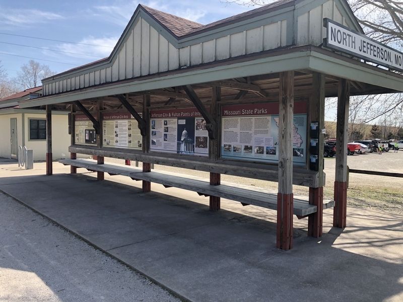
Other nearby markers. At least 8 other markers are within walking distance of this marker. Jefferson City & Fulton Points of Interest (here, next to this marker); N. Jefferson to Tebbetts (here, next to this marker); Missouri State Parks (here, next to this marker); N. Jefferson to Hartsburg (here, next to this marker); Lewis and Clark in Missouri (a few steps from this marker); Katy Trail State Park (within shouting distance of this marker); Bicentennial Monument (within shouting distance of this marker); The Great Flood of 1993 (within shouting distance of this marker). Touch for a list and map of all markers in Jefferson City.
Credits. This page was last revised on March 25, 2021. It was originally submitted on March 25, 2021, by Devry Becker Jones of Washington, District of Columbia. This page has been viewed 177 times since then and 18 times this year. Photos: 1, 2. submitted on March 25, 2021, by Devry Becker Jones of Washington, District of Columbia.

