
Forming for the Attack
The Battle of Spotsylvania Court House
| — | Fredericksburg and Spotsylvania National Military Park | — |
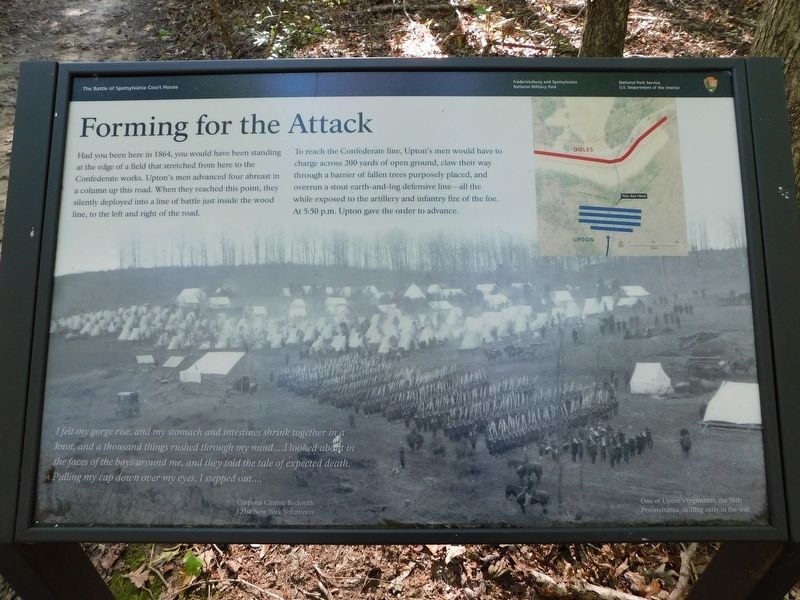
To reach the Confederate line, Upton's men would have to charge across 200 yards of open ground, claw their way through a barrier of fallen trees purposely placed, and overrun a stout earth-and-log defensive line—all the while exposed to the artillery and infantry fire of the foe. At 5:50 p.m. Upton gave the order to advance.
I felt my gorge rise, and Iny stomach and intestines shrink together in a knot, and a thousand things rushed through my mind....l looked about in the faces of the boys around me, and they told the tale of expected death. Dulling my cap down over my eyes, I stepped out....
Corporal Clinton Beckwith
121st New York Volunteers
(caption) One of Upton's regiments, the 96th Pennsylvania, drilling early in the war.
Erected by National Park Service, U.S. Department
this page online
Topics. This historical marker is listed in this topic list: War, US Civil. A significant historical year for this entry is 1864.
Location. 38° 13.342′ N, 77° 36.305′ W. Marker is in Spotsylvania Courthouse, Virginia, in Spotsylvania County. It can be reached from Grant Drive 0.7 miles north of Brock Road (County Route 613), on the right when traveling east. Located along Upton's Trail off of Grant Drive. Touch for map. Marker is at or near this postal address: 9550 Grant Drive, Spotsylvania VA 22553, United States of America. Touch for directions.

Regionally, this marker is in the Washington Metropolitan Area, in Northern Virginia, and in the Piedmont. It is also in the American South, specifically in the Upper South, in the Mid-Atlantic, and on the Eastern Seaboard. Globally, it is in the North Atlantic Region, North America, the Western Hemisphere, the Western World, and the Anglosphere. Historically, it finds itself in what was once the territory of the Mississippian Culture, one of the original Thirteen Colonies, one of the Confederate States of America, and the Antebellum South.
Other nearby markers. At
Other markers no longer nearby. Doles Salient (was about 600 feet away but has been permanently removed); Spotsylvania Campaign (was about 600 feet away but has been replaced with another marker now near it); a different marker also named Spotsylvania Campaign (was about 600 feet away but has been permanently removed); a different marker also named Spotsylvania Campaign (was approx. 0.2 miles away but has been permanently removed); a different marker also named Spotsylvania Campaign (was approx. 0.2 miles away but has been permanently removed).
Also see . . . Fredericksburg & Spotsylvania National Military Park. National Park
Credits. This page was last revised on April 2, 2021. It was originally submitted on March 29, 2021, by Bradley Owen of Morgantown, West Virginia. This page has been viewed 350 times since then and 25 times this year. Photos: 1, 2. submitted on March 29, 2021, by Bradley Owen of Morgantown, West Virginia. 3. submitted on April 1, 2021, by Bradley Owen of Morgantown, West Virginia. • Bernard Fisher was the editor who published this page.
