Louisa in Louisa County, Virginia — The American South (Mid-Atlantic)
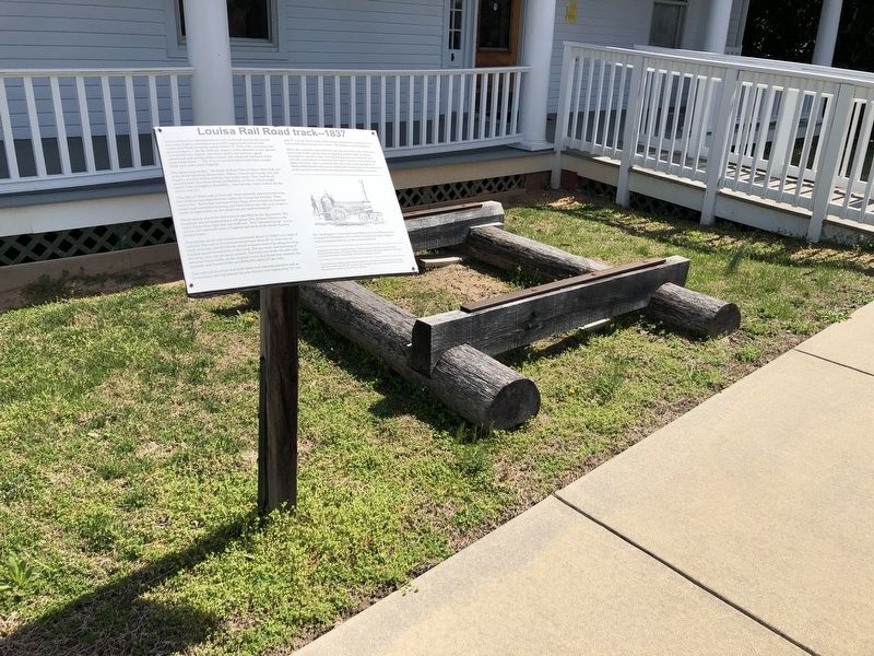
Louisa Rail Road track--1837

Featured here is a reproduction of a rail road track section that would have been built in accordance to an 1837 Agreement between the Louisa Rail-Road Company and providers of: "Rails, Sills (crossties) and Keys (wedges)…" for the railroad. Signers of the Agreement also agreed, "to haul the Iron, Spikes, and Plates, and to lay down in a good, substantial and workmanlike manner, the wood and ironworks of the Louisa Rail-Road....". The iron (strap rails) Spikes and Plates would likely have come from England.
The Agreement further: "the Rails, of Heart Pine or Heart White Oak, are to be of the following dimensions--Fifteen, twenty and twenty-five feet lengths, and five inches wide by nine inches deep. They shall be of sound timber, free from decay, windshakes, or knots, which might impair their strength or durability;… thus having a heart surface for the iron to rest on."
"The Sills of "White oak or Post oak" were similarly characterized to be free of decay and imperfections and to be strong and durable. They were to be: "Seven feet and nine inches long; eleven inches in diameter at the small end before hewing, and
this page online
The Roadway was to be laid down as specified by the Agreement. The emphasis was on maintaining a rail gauge (the distance between the rails) of four feet, eight and one-half inch. This "standard gauge" was in use for rail road beds both in England and most of the North-Eastern United States.
This section of rail and crossties represents about 1/1000th's of a mile of railroad. The cost of this section would have been $2.12. One mile of track structure cost $4,000.00. which includes costs of grading, leveling, excavating and installation of the track. The purchase and fastening of the strap rails cost an equal amount. The total cost of the 49-mile road between Taylorsville, on the original Louisa Rail Road near modern day Doswell, and Gordonsville was $408,000 or $8,327 per mile.
This railroad structure was both labor and material intensive and as locomotives became heavier was replaced by "U"-rail and "T"-rail. By 1853 nearly all the strap rail had been replaced on the Louisa Rail-Road and its new owner--the Virginia Central Railroad.
When
[Caption:]
The "Washington" a locomotive manufactured by the William Norris Company of Philadelphia, PA. in 1836. It would have been similar to early locomotives that ran on the Louisa Rail Road.
All quotes are from the original Articles of Agreement between the Louisa Rail-Road, Courtesy of the Library of Virginia. Other source material from "Early American Railroads" by Franz Anton Ritter Von Gerstner, Edited by Frederick C. Gamst.
Erected by Louisa County Historical Society.
Topics. This historical marker is listed in this topic list: Railroads & Streetcars. A significant historical year for this entry is 1837.
Location. Marker has been reported missing. It was located near 38° 1.506′ N, 77° 59.832′ W. Marker was in Louisa, Virginia, in Louisa County. It was on Fredericksburg Avenue (Virginia Route 628) 0.1 miles east of School Street (County Road T-1014), on the right when traveling east. Touch for map. Marker was at or near this postal address: 214 Fredericksburg Ave, Louisa VA 23093, United States of America. Touch for directions.

Regionally, this marker was in the Piedmont and in Central Virginia. It was also in the American South and specifically in the Upper South. Globally, it was in North America, the Western Hemisphere, the Western World, and the Anglosphere. Historically, it found itself in what was once the territory of the Mississippian Culture, one of the original Thirteen Colonies, one of the Confederate States of America, and the Antebellum South.
Other nearby markers. At least 8 other markers are within walking distance of this location: Hugh Hammond Bennett (1881-1960) (within shouting distance of this marker); Trevilians Schoolhouse (within shouting distance of this marker); Michie House (within shouting distance of this marker); Historic Louisa (approx. ¼ mile away); Louisa United Methodist Church (approx. 0.3 miles away); John Mercer Langston Birthplace (approx. 0.3 miles away); In Memory of All Veterans (approx. 0.3 miles away); Patrick Henry's Home (approx. 0.3 miles away). Touch for a list and map of all markers in Louisa.
More about this marker. Marker has been removed, but the replica track remains.
Credits. This page was last revised on August 12, 2026. It was originally submitted on April 4, 2021, by Devry Becker Jones of Washington, District of Columbia. This page has been viewed 463 times since then and 46 times this year. Photos: 1, 2. submitted on April 4, 2021, by Devry Becker Jones of Washington, District of Columbia.
