West Asheville in Buncombe County, North Carolina — The American South (South Atlantic)
"End of Car Line"
1890-1934
| — | Built by Edwin G. Carrier | — |
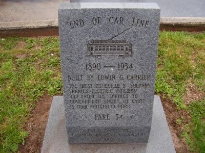
Photographed by Stanley and Terrie Howard, March 14, 2009
1. " End of Car Line " Marker
The West Asheville & Sulphur Springs Electric Railway ran from the springs to Government Street, at what is now Pritchard Park
Erected 1998 by The West Asheville Business Assoceation.
Topics. This historical marker is listed in this topic list: Railroads & Streetcars.
Location. 35° 34.643′ N, 82° 35.52′ W. Marker is in West Asheville, North Carolina, in Buncombe County. It is on Haywood Road (State Highway 19/23) west of Jarrett Street. Touch for map. Marker is in this post office area: Asheville NC 28806, United States of America. Touch for directions.

Regionally, this marker is in the Mountains and in Greater Asheville. It is also in the American South, specifically in the Upper South, in Appalachia, and specifically in Southern Appalachia. Globally, it is in North America, the Western Hemisphere, the Western World, and the Anglosphere. Historically, it finds itself in what was once the original Cherokee Nation, the territory of the Mississippian Culture, one of the original Thirteen Colonies, one of the Confederate States of America, and
this page online
Other nearby markers. At least 8 other markers are within 2 miles of this marker, measured as the crow flies: Olive Tilford Dargan (approx. 0.6 miles away); Electric Streetcars (approx. 1.2 miles away); Lynching in America / The Lynching of Hezekiah Rankin (approx. 1.4 miles away); Welcome to the River Arts District (approx. 1½ miles away); The Asheville Black Cultural Heritage Trail / Asheville's Black Newspapers / The Flood of 1916 (approx. 1½ miles away); Asheville's Southside (approx. 1.6 miles away); America's First Black Union Represents Ashevillians (approx. 1.6 miles away); William R. "Seaborn" Saxon (approx. 1.6 miles away).
Credits. This page was last revised on May 1, 2026. It was originally submitted on March 15, 2009, by Stanley and Terrie Howard of Greer, South Carolina. This page has been viewed 1,290 times since then and 38 times this year. Photo 1. submitted on March 15, 2009, by Stanley and Terrie Howard of Greer, South Carolina. • Kevin W. was the editor who published this page.
Editor’s want-list for this marker. Wide view photo showing marker in its surroundings. • Can you help?
