Stockton Springs in Waldo County, Maine — The American Northeast (New England)
Fort Pownall, 1759-1775
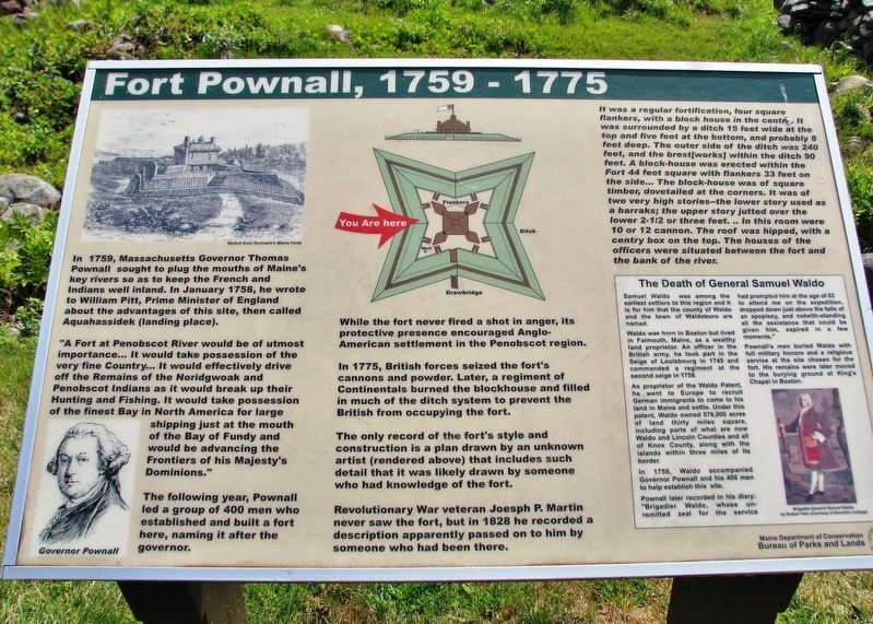
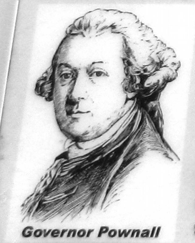
In 1759, Massachusetts Governor Thomas Pownall sought to plug the mouths of Maine's key rivers so as to keep the French and Indians well inland. In January 1758, he wrote to William Pitt, Prime Minister of England about the advantages of this site, then called Aquahassidek (landing place).
"A Fort at Penobscot River would be of utmost importance... It would take possession of the very fine Country... It would effectively drive off the Remains of the Noridgwoak and Penobscot Indians as it would break up their Hunting and Fishing. It would take possession of the finest Bay in North America for large shipping just at the mouth of the Bay of Fundy and would be advancing the Frontiers of his Majesty's Dominions."
The following year, Pownall led a group of 400 men who established and built a fort here, naming it after the governor.
While the fort never fired a shot in anger, its protective presence encouraged Anglo-American settlement in the Penobscot region.
In 1775, British forces seized the fort's cannons and powder. Later, a regiment of Continentals burned the blockhouse and filled in much of the ditch system to prevent the British from occupying the fort.
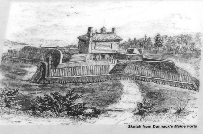
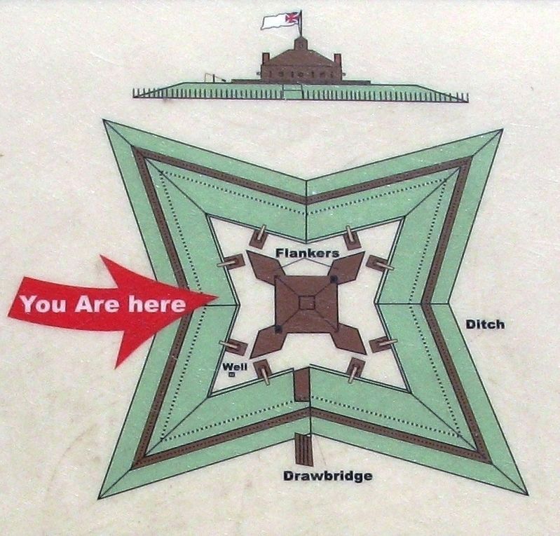
The only record of the fort's style and construction is a plan drawn by an unknown artist (rendered above) that includes such detail that it was likely drawn by someone who had knowledge of the fort.
Revolutionary War veteran Joseph P. Martin never saw the fort, but in 1828 he recorded a description apparently passed on to him by someone who had been there.
It was a regular fortification, four square flankers, with a block house in the centre. It was surrounded by a ditch 15 feet wide at the top and five feet at the bottom, and probably 8 feet deep. The outer side of the ditch was 240 feet, and the brest[works] within the ditch 90 feet. A block-house was erected within the Fort 44 feet square with flankers 33 feet on the side... The block-house was of square timber, dovetailed at the corners. It was of two very high stories — the lower story used as a barraks; the upper story jutted over the lower 2½ or three feet… In this room were 10 or 12 cannon. The roof was hipped, with a centry box on the top. The houses of the officers were situated between the fort and the bank of the river.
The Death of General Samuel Waldo
Samuel Waldo was among the earliest settlers to this region and it is for him that the county of Waldo and the town of Waldoboro are named.
Waldo was born in Boston but lived in Falmouth, Maine, as a wealthy land proprietor. An officer in the British army, he took part in the Siege of Louisbourg in 1745 and commanded a regiment at the second siege in 1758.
As proprietor of the Waldo Patent, he went to Europe to recruit German immigrants to come to his land in Maine and settle. Under this patent, Waldo owned 576,000 acres of land thirty miles square, including parts of what are now Waldo and Lincoln Counties and all of Knox County, along with the islands within three miles of its border.
In 1759, Waldo accompanied Governor Pownall and his 400 men to help establish this site.
Pownall later recorded in his diary: "Brigadier Waldo, whose unremitted zeal for the service had prompted him at the age of 63 to attend me on the expedition, dropped down just above the falls of an apoplexy, and notwithstanding all the assistance that could be given him, expired in a few moments."
Pownall's men buried Waldo with full military honors and a religious service at the site chosen for the fort. His remains were later moved to the burying ground at King's Chapel in Boston.
Erected by Maine Department of Conservation, Bureau of Parks and Lands.
Topics. This historical marker is listed in these topic lists: Forts and Castles • Settlements & Settlers • War, French and Indian • War, US Revolutionary. A significant historical year for this entry is 1759.
Location. 44° 28.088′ N, 68° 48.721′ W. Marker is in Stockton Springs, Maine, in Waldo County. Marker can be reached from State Park Road, one mile east of Cape Jellison Road. Marker is located in Fort Point State Park, overlooking the Fort Pownall site. Touch for map. Marker is in this post office area: Stockton Springs ME 04981, United States of America. Touch for directions.
Other nearby markers. At least 8 other markers are within 6 miles of this marker, measured as the crow flies. Fort Point State Park (within shouting distance of this marker); a different marker also named Fort Pownall (within shouting distance of this marker); The Home of a Hero / La maison d'un héros (approx. 5.1 miles away); Fort George & the Penobscot Expedition (approx. 5.4 miles away); Burial Place of British officers, (approx. 5.4 miles away); Fort George (approx. 5.4 miles away); The Growth of Ship Building: Isaac Carver / Le développement des chantiers navals : Isaac Carver (approx. 5½ miles away); Carver Memorial Library / La Bibliothèque Carver (approx. 5½ miles away). Touch for a list and map of all markers in Stockton Springs.
Regarding Fort Pownall, 1759-1775. National Register of Historic Places #69000028.
Also see . . .
1. Fort Pownall. Twelve Mile Circle website entry:
The mere presence of Fort Pownall had a tremendous impact on the entire Lower Penobscot watershed. People streamed into the area feeling a sense of protection and security from threats, real or imagined, from the French and the Indians. Towns sprang up all the way to Bangor and the countryside began to fill with settlers. Many of the towns in Waldo County can trace their years of incorporation to the decades immediately following the establishment of Fort Pownall. (Submitted on April 12, 2021, by Cosmos Mariner of Cape Canaveral, Florida.)
2. Thomas Pownall. Wikipedia entry:
During his term as Governor, he was known to travel out into the countryside, painting and talking to ordinary citizens, giving him a great understanding of, and sympathy for, the concerns of colonists. In John Adams’ opinion, Pownall was “the most constitutional and national governor in my opinion, who ever represented the Crown in this province.” He established lifelong friendships with many of the leading patriots, including Adams, James Bowdoin, John Hancock, and Benjamin Franklin. (Submitted on April 12, 2021, by Cosmos Mariner of Cape Canaveral, Florida.)
3. Brigadier-General Samuel Waldo. John Ellingsworth website entry:
Brigadier-General Samuel Waldo was a major player in 18th century Maine/Massachusetts colonial politics. The following biography of Samuel Waldo was transcribed from Genealogy of the Waldo family: a record of the descendants of Cornelius Waldo, of Ipswich, Mass., from 1647 to 1900. (Submitted on April 12, 2021, by Cosmos Mariner of Cape Canaveral, Florida.)
Credits. This page was last revised on November 18, 2021. It was originally submitted on April 12, 2021, by Cosmos Mariner of Cape Canaveral, Florida. This page has been viewed 251 times since then and 34 times this year. Photos: 1, 2, 3, 4, 5. submitted on April 12, 2021, by Cosmos Mariner of Cape Canaveral, Florida.


