Resaca in Gordon County, Georgia — The American South (South Atlantic)
Enduring the Battle of Resaca
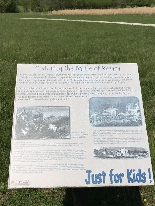
During the battle of Resaca, mainly north and west of town, cannon balls pierced storefronts and homes. Residents, who had not fled, cowered under furniture. The sounds of battle rang out night and day for almost a week, while soldiers moved through the village taking any food they could find. After the battle, one resident described the scene saying, “what houses there were left were literally torn in shreds by shot and shell.”
A Story from Resaca:
Fannie Oslin Jackson lived seven miles north of Resaca with her son Horace and several younger daughters. Fannie taught school and farmed. She lived in an unfinished house and owned one mule. Her husband served in the Confederate Army.
Fannie first saw the Confederate cavalry coming through the area on Sunday, May 8th, followed by the Yankees later in the day. On the 9th, Fanny reported that “Only those who have experienced it can have any idea of the feelings and fears such sights and sounds inspire in defenseless noncombatants within range of the guns.” When their fence was “thrown down to make place for a battery at the east end of the house,” Fannie decided to take her family and flee. Fannie and her fleeing neighbors came upon Union General McPherson who advised them to return to their homes as they would be safer there than in the mountains. By the end of the day, Fannie's home became a Union hospital filled with wounded men. Fannie served as their nurse.
Qu May 16th Fannie told of the “Incessant roar of cannon, the report of musketry, and the huzzahs and cheers of men as line after line of breastworks is charged and taken, may well make the stoutest heart tremble.” As the battle ended and the bridge over the Oostanaula burned, Fannie's immediate troubles ended. The armies moved South to fight again in a new place. Fannie was left with no food and little money. Her mule had been taken by the army: chickens, cows, and sheep slaughtered for food.
Captions
Left: "Harper's Weekly" illustration of soldiers foraging for food.
Right: There are no known photographs of Resaca's main street taken during or just after the Civil War. This engraving appeared in “Frank Leslie's illustrated London News” during the war. It shows Federal forces moving through Resaca at night. The railway station is shown in the center of the image.
The “Harper's Weekly” engraving below shows the village from a different view. Notice the difference in the roof line on the railway station. What other differences can you see? Since the artist often finished his sketch long after he left the area, you can understand how these two engravings might be different.
Erected by Georgia Department of Natural Resources - State Parks and Historic Sites.
Topics. This historical marker is listed in these topic lists: Settlements & Settlers • War, US Civil. A significant historical date for this entry is May 8, 1864.
Location. 34° 35.737′ N, 84° 57.706′ W. Marker is in Resaca, Georgia, in Gordon County. Marker can be reached from Resaca Lafayette Road Northwest (Georgia Route 136). Marker is along circular walkway near the pavilion at the end of Resaca Battlefield State Historic Site's entrance road. Touch for map. Marker is at or near this postal address: 6 GA-136, Resaca GA 30735, United States of America. Touch for directions.
Other nearby markers. At least 8 other markers are within walking distance of this marker. Stories from the Wild Hills of Resaca (here, next to this marker); Picturing a 19th-century Battle (within shouting distance of this marker); Site of Action — Judah's Division (within shouting distance of this marker); Did You Know That Both Sides Used Red, White and Blue Flags? (within shouting distance of this marker); Resaca Battlefield State Historic Site (within shouting distance of this marker); Site of Action — Carlin's Brigade (approx. ¼ mile away); How to Tell the Yankees from the Rebels! (approx. ¼ mile away); 103rd O.V.I. (approx. 0.4 miles away). Touch for a list and map of all markers in Resaca.
Credits. This page was last revised on April 14, 2021. It was originally submitted on April 14, 2021, by Duane and Tracy Marsteller of Murfreesboro, Tennessee. This page has been viewed 162 times since then and 14 times this year. Photos: 1, 2. submitted on April 14, 2021, by Duane and Tracy Marsteller of Murfreesboro, Tennessee.

