Sheridan in Placer County, California — The American West (Pacific Coastal)
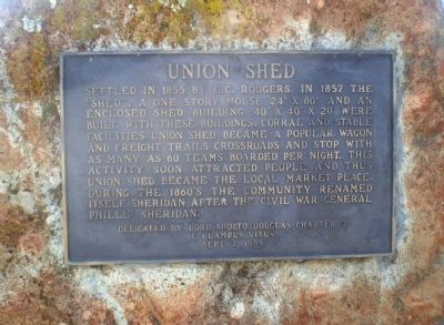
Union Shed
Erected 1985 by Lord Douglas Chapter 3, E Clampus Vitus.
Topics and series. This historical marker is listed in this topic list: Settlements & Settlers. In addition, it is included in the E Clampus Vitus series list. A significant historical year for this entry is 1855.
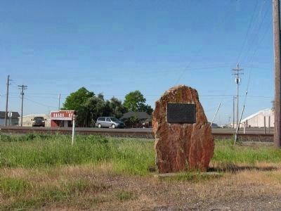
Location. 38° 58.837′ N, 121° 22.609′ W. Marker is in Sheridan, California, in Placer County. Marker is at the intersection of Thirteenth Street and H Street, on the left when traveling north on Thirteenth Street. Touch for map. Marker is in this post office area: Sheridan CA 95681, United States of America. Touch for directions.
Other nearby markers. At least 8 other markers are within 7 miles of this marker, measured as the crow flies. Sheridan Cemetery (approx. 1.1 miles away); Durst Hop Ranch (approx. 3.2 miles away); Holland House (approx. 3.2 miles away); Johnson's Ranch (approx. 3.2 miles away); Chinese Pyre (approx. 3.8 miles away); Overland Emigrant Trail (approx. 4.1 miles away); Manzanita (approx. 4.6 miles away); Truckee Trail – To Johnson Ranch (approx. 6.7 miles away).
More about this marker. In Historic Spots in California, Mildred Hoover notes Union Shed's ideal location, being at a crossroads with roads branching off to Nicolaus, Marysville, Grass Valley, and Auburn. When the California Central Railroad reached Wheatland in 1866, the importance of the staging and teaming business was greatly diminished. In 1868, the Union Shed burned down.
Credits. This page was last revised on June 16, 2016. It was originally submitted on March 18, 2009, by Andrew Ruppenstein of Lamorinda, California. This page has been viewed 1,324 times since then and 28 times this year. Photos: 1. submitted on March 18, 2009, by Andrew Ruppenstein of Lamorinda, California. 2. submitted on April 6, 2009. • Kevin W. was the editor who published this page.

