Our Lady of Penrhys
English
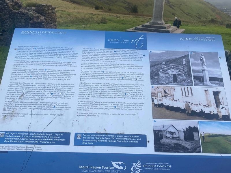
The area where Penrhys now stands has a long and rich history. As the site of a religious shrine dedicated to 'Our Lady Mary' (1) it was one of the most famous pilgrimage sites of the medieval period. The tradition of pilgrimages to religious shrines dates back over a thousand years and during medieval times they were a major industry. Here the shrine was used as a healing spring and was said to be able to cure rheumatism and eye disorders. Today it is still a popular destination with pilgrims who follow the Cistercian Way around Wales, to discover the great abbeys of the Cistercian order, visit. (http://cistercian-way.newport.ac.uk)
A statue of Mary nursing Jesus marked the site of the shrine for many centuries. However during the 1530s at the time of the dissolution of the monasteries under Henry VIII it was removed and taken to London to be publicly destroyed on the orders of the king's chancellor Thomas Cromwell.
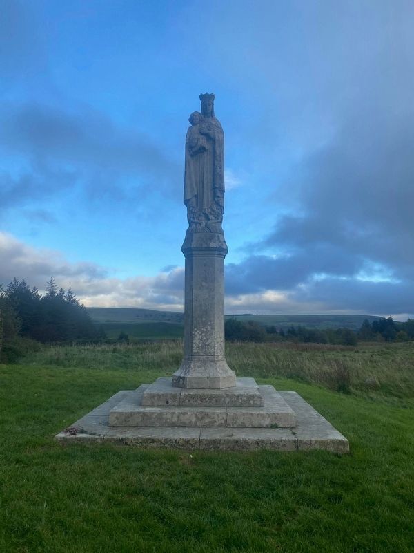
The current 'Our Lady' statue (2) is carved from Portland Stone. The design is based on descriptions of the original statue taken from medieval Welsh poetry. The Archbishop of Cardiff, Michael Joseph McGrath, blessed the statue on the 2nd July 1953. Following this many thousands have made the modern pilgrimage (3)to the shrine. In 1977 the first pilgrimage of the sick to Penrhys for over 450 years
saw over 2,000 people visit the shrine. In the Rhondda, as all over the South Wales Valleys, the coming of industry came with a price. Life expectancy was low and infant mortality high. Houses could not be built quick-enough for the vast number of people who arrived to work. Existing supplies of fresh water and the primitive sanitation could not cope with the demands of a growing population and outbreaks of diseases such as the highly contagious smallpox were common. In 1906 it was decided to build a smallpox hospital (4) at Penrhys. Built at a cost of £35,000 it was completed in 1907 and served the community until 1970. After its closure, in 1971, the South Wales Fire Service burnt it to the ground to destroy all traces of any viruses.
In 1991 the Penrhys Partnership was established to develop the social infrastructure of the community. They have developed a local Heritage Trail; an outdoor Amphitheatre and a Millennium Beacon. Rhondda Golf Club opposite combines the wonderful wildness of the area with a challenging golf course and stunning views as far as the Bristol Channel.
An informative driving trail will enable you to explore the area in more depth (www.heritagetrailsrct.co.uk)
Welsh
Mae hanes hir a chyfoethog ir ardal lle saif Pen-rhys heddiw. Fel safle cysegrfa
grefyddol i'r Forwyn Fairo,(1) dyma oedd un o safleoedd pererindod enwocaf y
canoloesoedd.
Arfarai'r gysegrfa gynnwys cerfiun o Fair yn magu'r baban lesu am ganrifoedd maith, ond yn ystod ymgyrch diddymu'r mynachiogydd dan law Harri VIII yn y 1530au, cafodd ei symud i Lundain i'w ddifrodi'n gyhoeddus dan orchymyn Thomas Cromwel. canghellor y brenin.
Mae'r cerflun presennol o Forwyn Pen-rhys (2) ewedi'i naddu o garreg Portland. Mae'r cynllun yn seiliedig ar ddisgrifiadau o'r cerflun gwreiddiol mewn barddoniaeth ganoloesol Gymraeg. Cafodd y cerflun newydd ei fendithio gan Archesgob Caerdydd, Michael Joseph McGrath, ar 2 Gorffennaf 1953. Ar ôl hynny, heidiodd miloedd i'r gysegrfa ar y bererindod (3)fodem gyntaf. Daeth dros 2,000 o bobl yno ym 1977 mewn pererindod i'r clwyfedigion, y cyntaf o'i bath ym Mhen-rhys ers dros 450 mlynedd.
Talodd pobl Cwm Rhondda yn ddrud am dwf diwydiant yn yr ardal, fel sawl rhan arall o gymoedd y De. Roedd disgwyliad oes yn isel a lefelau uchel o farwolaethau ymhlith babanod. Doedd dim hanner digon o
dai ar gael i'r don ar ôl ton o weithwyr newydd. Ni allai'r cyflenwadau dwr ffres a'r cyfleusterau glanweithdra cyntefig ddygymod â gofynion cynyddol y boblogaeth, ac roedd achosion o glefydau heintus fel y frech wen yn gyffredin. Ym 1906. penderfynwyd codi ysbyty'r frech (4) wen ym Mhen-rhys ar gost o £35,000. Cwblhawydy gwaith adeiladu ym 1907 a bu'n gwasanaethu'r gymuned tan 1970. Ym 1971, aeth Gwasanaeth Tân y De ati i losgi'r hen ysbyty i'r llawr er mwyn cael gwared ar unrhyw olion firysau o'r tir yn llwyr.Ym 1991, sefydiwyd Partneriaeth Pen-rhys i ddatblygu rhwydwaith cymdeithasol mewnol yn y gymuned. Mae'r bartneriaeth wedi datblygu Llwybr Treftadaeth lleol, Amffitheatr a Ban y Mileniwm. Mae Clwb Golff Cwm Rhondda (5) gyferbyn yn cyfuno gwylltineb thyfeddol yr ardal â chwrs golff heriol, a golygfeydd syfrdanol.mor bell â Mor Hafren
Mae taith yrru llawn gwybodaeth yn eich helpu i archwilio'r ardal yn fanylach
(wwww.heritagetrailsrct.co.uk)
Erected by Rhondda Cynon Taf Heritage Trails Llwybrau Treftadaeth.
Topics. This historical marker is listed in this topic list: Churches & Religion.
Location. 51° 38.493′ N, 3° 26.602′ W. Marker is in Penrhys, Wales, in Rhondda Cynon Taff. Marker can be reached from the intersection of Penrhys Road (County Road B4512) and Heol Pendyrus. Touch for map. Marker is in this post office area: Penrhys, Wales CF43 3PT, United Kingdom. Touch for directions.
Other nearby markers. At least 8 other markers are within 8 kilometers of this marker, measured as the crow flies. George Henry Hall (approx. 6.5 kilometers away); Arthur Linton (approx. 6.7 kilometers away); a different marker also named Arthur Linton (approx. 6.7 kilometers away); Edwin Greening (approx. 7.5 kilometers away); James Keir Hardie, MP (approx. 7.9 kilometers away); Aberdare Points of Interest - Monk Street (approx. 7.9 kilometers away); Aberdare Points of Interest - High Street (approx. 7.9 kilometers away); James James (Iago ap Ieuan) (approx. 7.9 kilometers away).
Credits. This page was last revised on January 27, 2022. It was originally submitted on May 7, 2021, by Cajun Scrambler of Assumption, Louisiana. This page has been viewed 98 times since then and 11 times this year. Photos: 1. submitted on May 7, 2021, by Cajun Scrambler of Assumption, Louisiana. 2. submitted on May 9, 2021, by Cajun Scrambler of Assumption, Louisiana.
Editor’s want-list for this marker. A Wide shot of this marker and surrounding area • Can you help?

