Waimea in Hawaii County, Hawaii — Hawaiian Island Archipelago (Pacific Ocean)
Pu'ukoholā Heiau
Pu'ukoholā Heiau National Historic Site
— National Park Service, U.S. Department of the Interior —
Build a heiau on Pu'ukohola, the "hill of the whale," dedicate it to your war god, and you will achieve your dream — you will rule the islands. Responding to this prophecy told by Kapoukahi, a famous seer, Kamehameha built the heiau (temple) that stands before you.
Work began in 1790. Workers carefully set tons of waterworn lava rock in place without mortar. Kamehameha labored with them. Only his brother was excused, because he would preside over deciation rituals upon Pu'ukohola Heiau and had to remain ceremonially clean. To please the war god, the heiau had to be ritually perfect.
By the summer of 1791, the heiau was complete. Soon Kamehameha ruled Hawai'i, then Maui, Lāna'i, Moloka'i, and O'ahu. When he added Kaua'i through peaceful negotiations in 1810, the prophecy was fulfilled — Kamehameha the Great ruled all of the Hawaiian Islands.
[Captions:]
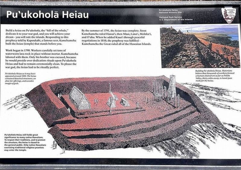
Pu'ukoholā Heiau as it may have appeared around 1800. The heiau contained thatched structures, an altar for offerings, and wooden images of gods.
Pu'ukoholā Heiau still holds great significance to many native Hawaiians. To respect their traditions, and to protect the structure, the heiau is closed to the general public. Only native Hawaiians exercising traditional practices may enter the temple.
Building Pu'ukoholā Heiau. Historians believe that thousands of workers formed a human chain from as far as Pololū Valley, thirty miles away, to hand-pass rocks for the heiau.
Erected by National Park Service, U.S. Department of the Interior.
Topics. This historical marker is listed in these topic lists: Asian Americans • Churches & Religion • Government & Politics. A significant historical year for this entry is 1790.
Location. 20° 1.609′ N, 155° 49.343′ W. Marker is in Waimea, Hawaii, in Hawaii County. Marker can be reached from Spencer Beach Park Road, 0.2 miles west of Kawaihae Road (Hawaii Route 270), on the right when traveling west. Touch for map. Marker is in this post office area: Waimea HI 96796, United States of America. Touch for directions.
Other nearby markers. At least 8 other markers are within 6 miles of this marker, measured as the crow flies. Pu'ukohlā Heiau (within shouting distance of this marker); Mailekini Heiau (about 300 feet away, measured in a direct line); Pu'ukohola Heiau (about 400 feet away); Hale o Kapuni Heiau (about 400 feet away); Pelekane (about 500 feet away); Pu'ukohola Heiau National Historic Site (about 500 feet away); Camp Henry C. Drewes (approx. 2˝ miles away); Puakō Petroglyph Archaeological District (approx. 5˝ miles away). Touch for a list and map of all markers in Waimea.
Credits. This page was last revised on November 7, 2022. It was originally submitted on May 9, 2021. This page has been viewed 185 times since then and 25 times this year. Photo 1. submitted on May 9, 2021. • Devry Becker Jones was the editor who published this page.
Editor’s want-list for this marker. A wide shot of the marker in context. • Can you help?
