Eatonton in Putnam County, Georgia — The American South (South Atlantic)
Eatonton Presbyterian Church
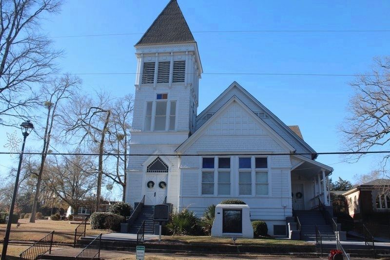
Eatonton Presbyterians, Baptists, Methodists, Christians, and the Masonic Lodge joined together in 1818 to build the Old Union Church on land donated by James Shackleford from his 23 acre home tract. He specified the land be used for a church, a cemetery and the new Church Street. This land adjoined the 1808 Academy Grove tract which had been set aside for the academy. On June 24, 1819 the Masons, led by the Rev. John Brown, marched from the nearby Eatonton Academy, chartered in 1818, to lay the cornerstone of the new Union Church. Members of the subscribing congregations joined the procession. The congregations used it on a rotating basis with fifth Sunday use by the Masons. Built where the present library parking lot lies, it faced south. The New England Congregationalist style church, with a tall steeple and fine bell, was one of the largest in upcountry GA. Hopewell Presbytery records show 20 members in 1820 when the Presbytery met in the new Union Church. By 1880 there were 35 Presbyterians and then to 107 by the 1890's. The Methodists left in 1857 to occupy their new building and the Christians ceased to meet. Presbyterians and Baptists used the Union Church until the Baptists occupied their new church in March 1897. The Presbyterians had petitioned the Mayor and Aldermen in 1891 to approve a land exchange with the Academy Trustees: the old church building for a new 80' by 100' lot in Academy Grove facing N. Madison Ave. Contractor C.D. Leonard built the Queen Anne Victorian church from plans by Atlanta architects Bruce & Morgan (revised by Respess & Co. of Atlanta). Ground was broken on July 13, 1896, at 6:00 PM. R. B. Nisbet was granted a special dispensation to act as Grand Master in the impressive Masonic ritual laying the August 6, 1896 cornerstone, made from the old 1819 cornerstone. The April 25, 1897 dedication service was led by the Rev. J.M. Plowdden, the address was given by the Rev. Robert Adams, D. D., and Mrs. Clark M. Davis served as organist. The Old Union Church was taken down in July 1897 and the materials sold. Its original “fine-toned bell weighing 300 pounds” was hung in the new Presbyterian steeple and the wide granite steps were used as coping along the N. Madison Ave. sidewalk. The new Callaway Fellowship Hall addition, designed by Will Durham to match the original church, was dedicated on May 24, 1992.
Erected 2016 by Eatonton Presbyterian Church and the Eatonton-Putnam County Historical Society, Inc.
Topics. This historical marker is listed in these topic lists: Cemeteries & Burial Sites • Churches & Religion • Settlements & Settlers. A significant historical year for this entry is 1808.
Location.

Photographed By Tim Fillmon, December 28, 2020
2. Eatonton Presbyterian Church and Marker
Church website and history
Click for more information.
Click for more information.
Other nearby markers. At least 8 other markers are within walking distance of this marker. Site of John C. Mason's Dwelling House (approx. 0.2 miles away); The Bronson House (approx. 0.2 miles away); Childhood Home of Joel Chandler Harris (approx. 0.2 miles away); Putnam County Confederate Monument (approx. ¼ mile away); The Stoneman Raid (approx. ¼ mile away); Putnam County (approx. ¼ mile away); The March to the Sea (approx. ¼ mile away); Putnam County Court House (approx. 0.3 miles away). Touch for a list and map of all markers in Eatonton.
Credits. This page was last revised on July 15, 2021. It was originally submitted on May 17, 2021, by Tim Fillmon of Webster, Florida. This page has been viewed 200 times since then and 27 times this year. Photos: 1, 2. submitted on May 17, 2021, by Tim Fillmon of Webster, Florida.
