Near Chitina in Valdez-Cordova Census Area, Alaska — Northwest (North America)
Railway to Riches
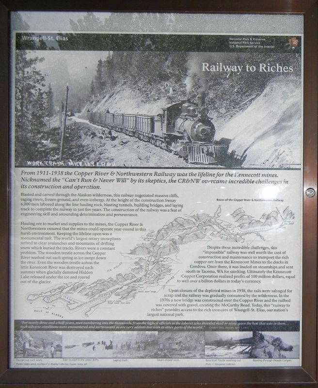
Blasted and carved through the Alaskan wilderness, this railway negotiated massive cliffs, raging rivers, frozen ground, and even icebergs. At the height of the construction frenzy 6,000 men labored along the line hauling rock, blasting tunnels, building bridges, and laying track to complete the railway in just five years. The construction of the railway was a feat of engineering skill and astounding determination and perseverance.
Hauling ore to market and supplies to the mines, the Copper River & Northwestern ensured that the mines could operate year-round in this harsh environment. Keeping the lifeline open was a monumental task. The world's largest rotary snowplows strived to clear avalanches and mountains of drifting snow which buried the tracks. Rivers were a constant problem. The wooden trestle across the Copper River washed out each spring as ice swept down the river. Even the wooden trestle across the little Kennicott River was destroyed each summer when glacially dammed Hidden Lake released under the ice and roared out of the glacier.
Despite these incredible challenges, this “impossible” railway was well worth the cost of construction and maintenance to transport the rich copper ore from the Kennecott Mines to the docks in Cordova. Once there, it was loaded on steamships and sent south to Tacoma, WA for smelting. Ultimately the Kennecott Copper Corporation realized profits of 100 million dollars, equal to well over a billion dollars in today's currency.
Upon closure of the depleted mines in 1938, the rails were salvaged for scrap and the railway was gradually consumed by the wilderness. In the 1970s a new bridge was constructed over the Copper River and the railbed was covered with gravel, creating the McCarthy Road. Today, this “railway to riches” provides access to the rich treasures of Wrangell-St. Elias, our nation's largest national park.
“For nearly three and a half years, men numbering into the thousands, from the highest officials to the laborer who shoveled mud or snow, gave the best that was in them … such adverse conditions were encountered and surmounted as are very seldom met with in other parts of the world.” — Cordova Daily Alaskan, April 1, 1911Captions:
Top: Work train, mile 113, C.R.N.W.
Bottom, left to right:
• Dangerous rock work.
• Train buried in the snow drifts.
• Laying track.
• Steam shovel work.
• Kennicott Trestle washing out. Photo: C. Waugaman Collection
• Blasting through Woods Canyon.
Photos: Unless noted, courtesy of G. Bleakley Collection, Copper Center, AK
Erected by National Park Service.
Topics. This historical marker is listed in these topic lists: Industry & Commerce • Railroads & Streetcars. A significant historical year for this entry is 1911.
Location. 61° 26.287′ N, 143° 43.167′ W. Marker is near Chitina in Valdez-Cordova Census Area, Alaska. Marker is on McCarthy Road (at milepost 29), on the left when traveling west. Touch for map. Marker is in this post office area: Chitina AK 99566, United States of America. Touch for directions.
Other nearby markers. At least 1 other marker is within walking distance of this marker. Wooden Wonder (here, next to this marker).
More about this marker. Marker is located in a pulloff on the west side of the Gilahina River. McCarthy Road is an unpaved, gravel road often laced with potholes that winds along the former railroad route through remote, rugged terrain. It is closed in the winter.
Also see . . .
1. Travel on the Copper River & Northwestern Railway (YouTube). A clip of travel on the Copper River and Northwestern Railway in the late 1920s. It is from "Through Alaska with A.A. Humfrey and Red Can" (a reference To Hills Brothers Coffee) which records a five-month tour through Alaska. The film is held by the Alaska Film Archives, a unit of the Alaska & Polar Regions Department at the University of Alaska Fairbanks. (Submitted on May 25, 2021, by Duane and Tracy Marsteller of Murfreesboro, Tennessee.)
2. Copper River and Northwestern Railway (Wikipedia). (Submitted on May 25, 2021, by Duane and Tracy Marsteller of Murfreesboro, Tennessee.)
Credits. This page was last revised on May 25, 2021. It was originally submitted on May 25, 2021, by Duane and Tracy Marsteller of Murfreesboro, Tennessee. This page has been viewed 123 times since then and 19 times this year. Photo 1. submitted on May 25, 2021, by Duane and Tracy Marsteller of Murfreesboro, Tennessee.
Editor’s want-list for this marker. Wide shot of marker and surrounding area. • Can you help?
