Silver Springs in Valdez-Cordova Census Area, Alaska — Northwest (North America)
Violent Silhouettes
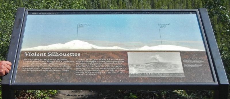
The older Mount Drum is a stratovolcano — or a very explosive shield volcano. Stratovolcanoes are steeper and more conical than shield volcanoes. Pasty lava deposits exploded skyward in successive eruptions to fashion the mountain bulk. From this angle Mount Drum appears taller than Mount Wrangell, though it is actually 2,000 feet shorter. But as recently as 250,000 years ago Mount Drum was 2,000 feet taller — that is, before its top blew off.
Captions:
Top:
• Mount Drum - Hwdaandi K´elt´aeni -12,010 ft - 3,661 m
• Mount Wrangell - K´elt´aeni- 14,163 ft - 4,317 m
Bottom right: Dark volcanic ash blankets Mount Wrangell while a steam plume rises from an active crater around 1902. Thousands of volcanic lava flows, covering more than 4,000 square miles, compose the Wrangell Mountains.
Topics. This historical marker is listed in this topic list: Environment. A significant historical year for this entry is 1902.
Location. 62° 1.23′ N, 145° 21.741′ W. Marker is in Silver Springs in Valdez-Cordova Census Area, Alaska. Marker can be reached from Wrangell St Elias Visitor Center, 0.3 miles east of Richardson Highway (Alaska Route 4), on the right when traveling east. Marker is on the Boreal Forest Trail at Wrangell-St. Elias National Park Visitor Center. Touch for map. Marker is in this post office area: Copper Center AK 99573, United States of America. Touch for directions.
Other nearby markers. At least 1 other marker is within walking distance of this marker. Ciisi nekeghalts´et (about 300 feet away, measured in a direct line).
Credits. This page was last revised on June 11, 2021. It was originally submitted on May 25, 2021, by Duane and Tracy Marsteller of Murfreesboro, Tennessee. This page has been viewed 130 times since then and 8 times this year. Photos: 1, 2. submitted on May 25, 2021, by Duane and Tracy Marsteller of Murfreesboro, Tennessee.

