Sturgis in Meade County, South Dakota — The American Midwest (Upper Plains)
Broken Promises
The Story of our History
Photographed by Ruth VanSteenwyk, April 24, 2021
1. Broken Promises Marker
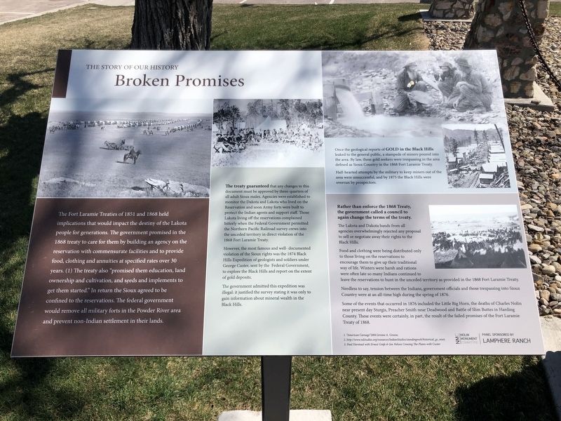
The treaty guaranteed that any changes to this document must be approved by three-quarters of all adult Sioux males. Agencies were established to monitor the Dakota and Lakota who lived on the Reservation and soon Army forts were built to protect the Indian agents and support staff. Those Lakota living off the reservations complained bitterly when the Federal Government permitted the Northern Pacific Railroad survey crews into the unceded territory in direct violation of
this page online
However, the most famous and well-documented violation of the Sioux rights was the 1874 Black Hills Expedition of geologists and soldiers under George Custer, sent by the Federal Government, to explore the Black Hills and report on the extent of gold deposits.
The government admitted this expedition was illegal: it justified the survey stating it was only to gain information about mineral wealth in the Black Hills.
Once the geological reports of Gold in the Black Hills leaked to the general Public, a stampede of miners poured into the area. By law, these gold seekers were trespassing in the area defined as Sioux Country in the 1868 Fort Laramie Treaty.
Half-hearted attempts by the military to keep miners out of the area were unsuccessful, and by 1875 the Black Hills were overrun by prospectors.
Rather than enforce the 1868 Treaty, the government called a council to again change the terms of the treaty.
The Lakota and Dakota bands from all agencies overwhelmingly rejected any proposal to sell or negotiate away their rights to the Black Hills.
Food and clothing were being distributed
Photographed by Ruth VanSteenwyk, April 24, 2021
2. Broken Promises Marker
Needless to say, tension between the Indians, government officials and those trespassing into Sioux Country were at an all-time high during the spring of 1876.
Some of the events that occurred in 1876 included the Little Big Horn, the deaths of Charles Nolin near present day Sturgis, Preacher Smith near Deadwood and Battle of Slim Buttes in Harding County. These events were certainly, in part, the result of the failed promises of the Fort Laramie Treaty of 1868.
1. "American Carnage" 2004 Jerome A. Greene.
2. Http//www.ndstudies.org/resources/IndianStudies/standingrock/historical_gs_reser.
3. Paul Horstead with Ernest Grafe & Jon Nelson Crossing The Plains with Custer
Erected by Nolin Monument Committee and Lamphere Ranch.
Topics. This historical marker is listed in these topic lists: Indigenous Peoples and Communities • Settlements & Settlers. A significant historical year for this entry is 1851.
Location. 44° 24.127′ N, 103° 30.537′ W. Marker is in Sturgis, South Dakota, in Meade County. It is at the intersection of Junction Avenue and Harmon Street on Junction Avenue. Located near the Sturgis Regional Hospital. Touch for map. Marker is at or near this postal address: 2140 Junction Ave, Sturgis SD 57785, United States of America. Touch for directions.

Regionally, this marker is in West River and in Greater Rapid City. It is also in the American Lewis & Clark Corridor, on the prairies, and on the Northern Plains. Globally, it is in North America, the Western Hemisphere, the Western World, and the Anglosphere. Historically, it finds itself in what was once Rupert’s Land and also the Louisiana Purchase.
Other nearby markers. At least 8 other markers are within 2 miles of this marker, measured as the crow flies: The Fate of the Mail Carrier (here, next to this marker); Charles Nolin (here, next to this marker); Treaties are formed (here, next to this marker); Born of Opportunity (a few steps from this marker); The Peace Keeping Post (a few steps from this marker); Charles Nolin, Pony Mail Carrier (a few steps from this marker); a different marker also named Charles Nolin (approx. 0.9 miles away); Civilian Conservation Corps Camps (approx. 1½ miles away). Touch for a list and map of all markers in Sturgis.
Credits. This page was last revised on May 30, 2021. It was originally submitted on May 28, 2021, by Ruth VanSteenwyk of Aberdeen, South Dakota. This page has been viewed 300 times since then and 21 times this year. Photos: 1, 2. submitted on May 28, 2021, by Ruth VanSteenwyk of Aberdeen, South Dakota. • Mark Hilton was the editor who published this page.
