Parkers Crossroads in Henderson County, Tennessee — The American South (East South Central)
Confederate Artillery Position
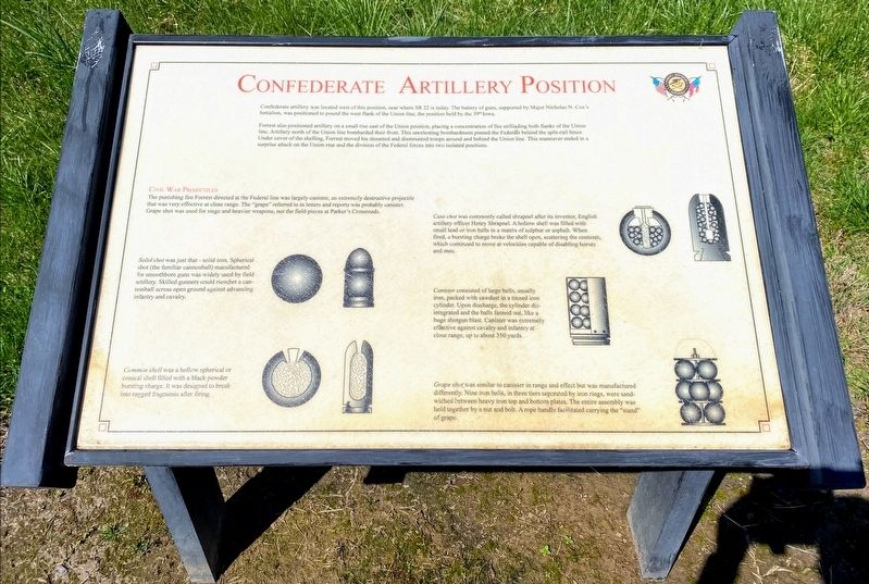
Confederate artillery was located west of this position, near where SR 22 is today. The battery of guns, supported by Major Nicholas N. Cox's battalion, was positioned to pound the west flank of the Union line, the position held by the 39th Iowa.
Forrest also positioned artillery on a small rise east of the Union position, placing a concentration of fire enfilading both flanks of the Union line. Artillery north of the Union line bombarded their front. This unrelenting bombardment pinned the Federals behind the split-rail fence. Under the cover of shelling, Forrest moved his mounted and dismounted troops around and behind the Union line. This maneuver ended in a surprise attack on the Union rear and the division of the Federal forces into two isolated positions.
Civil War Projectiles
The punishing fire Forrest directed at the Federal line was largely canister, an extremely destructive projectile that was very effective at close range. The "grape" referred to in letters and reports was probably canister. Grape shot was used for siege and heavier weapons, not the field pieces at Parker's Crossroads.
Solid shot was just that - solid iron. Spherical shot (the familiar cannonball) manufactured for smoothbore guns was widely used by field artillery. Skilled gunners could ricochet a cannonball across open ground against advancing infantry and cavalry.
Common shell was a hollow spherical or conical shell filled with a black powder bursting charge. It was designed to break into ragged fragments after firing.
Case shot was commonly called shrapnel after its inventor, English artillery officer Henry Shrapnel. A hollow shell was filled with small lead or iron balls in a matrix of sulphur or asphalt. When fired, a bursting charge broke the shell open, scattering the contents, which continued to move at velocities capable of disabling horses and men.
Canister consisted of large balls, usually iron, packed with sawdust in a tinned iron cylinder. Upon discharge, the cylinder disintegrated and the balls fanned out, like a huge shotgun blast. Canister was extremely effective against cavalry and infantry at close range, up to about 350 yards.
Grape shot was similar to canister in range and effect but was manufactured differently. Nine iron balls, in three tiers separated by iron rings, were sandwiched between heavy iron top and bottom plates. The entire assembly was held together by a nut and bolt. A rope handle facilitated carrying the "stand" of grape.
Erected by Parker's Crossroads Battlefield Association.
Topics. This historical marker is listed in this topic list: War, US Civil. A significant historical date for this entry is December 31, 1862.
Location. 35° 47.205′ N, 88° 23.311′ W. Marker is in Parkers Crossroads, Tennessee, in Henderson County. Marker is on Federal Lane, 0.2 miles east of Tennessee Route 22, on the right when traveling east. Marker is located along the South Battlefield Trail, at Auto Tour Stop No. 7 of the Parker's Crossroads Battlefield Auto Tour. Touch for map. Marker is in this post office area: Wildersville TN 38388, United States of America. Touch for directions.
Other nearby markers. At least 8 other markers are within walking distance of this marker. The Lexington-Huntingdon Road (about 400 feet away, measured in a direct line); Dunham's Position (about 500 feet away); Cyrus Livingston Dunham (about 500 feet away); "The General Demands An Unconditional Surrender" (about 500 feet away); A Very Successful Campaign (about 500 feet away); Withdrawal to the Split-Rail Fence (about 600 feet away); Three Desperate Charges (about 600 feet away); McPeake Cabin (about 600 feet away). Touch for a list and map of all markers in Parkers Crossroads.
Also see . . . Parker's Crossroads Battlefield Association. (Submitted on June 3, 2021.)
Credits. This page was last revised on July 24, 2021. It was originally submitted on May 28, 2021, by Shane Oliver of Richmond, Virginia. This page has been viewed 91 times since then and 8 times this year. Photos: 1. submitted on May 28, 2021, by Shane Oliver of Richmond, Virginia. 2. submitted on July 24, 2021, by Darren Jefferson Clay of Duluth, Georgia. • Bernard Fisher was the editor who published this page.

