Parkers Crossroads in Henderson County, Tennessee — The American South (East South Central)
Forrest Seizes the Advantage
Chaos in Retreat
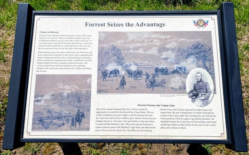
Colonel Cyrus Dunham held his position south of the cotton field for over an hour. When his infantry failed to take the Confederate artillery, he gave the order "rally to the rear." It was about noon when the Union line fell back to a sixty-acre stand of timber bordered by a split-rail fence. [You can see the reconstructed fence on the far side of the interstate.]
When Dunham gave the order to fall back, the 39th Iowa, the least experienced regiment in the Union force, panicked and began rushing toward the fence. Colonel Henry Cummings tried to reform his regiment but failed. Confederate General Nathan Bedford Forrest ordered a general advance. His cavalry pushed forward and opened on the retreating soldiers with small arms and artillery fire, further spooking the Iowans.
Forrest Presses the Union Line
The Union retreat shortened their line. Forrest seized the opportunity to extend his line beyond the Union flanks. The arc of the Confederate line grew tighter, and the distance between the Union line and Forrest's artillery grew shorter. Forrest moved Captain Samuel L. Freeman's four-gun battery to the east where it could enfilade Dunham's line. This action placed Freeman's cannon almost square with Dunham's right flank and allowed the guns to fire across the whole line. The effect was devastating.
On the Union left, Forrest captured the federal guns and wagon train. He sent a detachment of soldiers through the woods on the Union right. By extending his line beyond the Union position, Forrest sought to get behind Dunham. He intended to press the Union line with his artillery and round up fleeing soldiers as they broke for the rear. It was a solid plan, and it almost worked.
(caption)
Col. Henry J.B. Cummings, 39th Iowa Infantry
Erected 2015 by Parker's Crossroads Battlefield Association.
Topics. This historical marker is listed in this topic list: War, US Civil. A significant historical date for this entry is December 31, 1862.
Location. 35° 47.577′ N, 88° 23.089′ W. Marker is in Parkers Crossroads, Tennessee, in Henderson County. Marker can be reached from Wildersville Road, 0.2 miles east of Tennessee Route 22, on the right when traveling east. Marker is located along the North Battlefield Trail Extension, south of Wildersville Road. The North Battlefield Trail begins at the Parker's Crossroads City Park: Auto Tour Stop No. 1 of the Parker's Crossroads Battlefield Auto Tour. Touch for map. Marker is in this post office area: Wildersville TN 38388, United States of America. Touch for directions.
Other nearby markers. At least 8 other markers are within walking distance of this marker. A Fire Terrible In Its Intensity (about 300 feet away, measured in a direct line); Dunham Strikes Back (about 500 feet away); Forrest's Big Show (about 600 feet away); Dibrell's Position (about 700 feet away); A Panicked Stampede (approx. 0.2 miles away); Forrest's Artillery Leads the Attack (approx. 0.2 miles away); Manning the Guns (approx. 0.2 miles away); Civil War Artillery (approx. 0.2 miles away). Touch for a list and map of all markers in Parkers Crossroads.
Also see . . . Parker's Crossroads Battlefield Association. (Submitted on June 3, 2021.)
Credits. This page was last revised on July 24, 2021. It was originally submitted on May 29, 2021, by Shane Oliver of Richmond, Virginia. This page has been viewed 97 times since then and 6 times this year. Photos: 1. submitted on May 29, 2021, by Shane Oliver of Richmond, Virginia. 2. submitted on July 24, 2021, by Darren Jefferson Clay of Duluth, Georgia. • Bernard Fisher was the editor who published this page.

